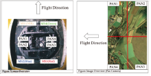
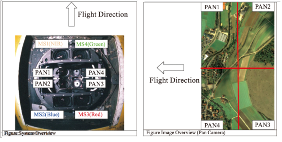
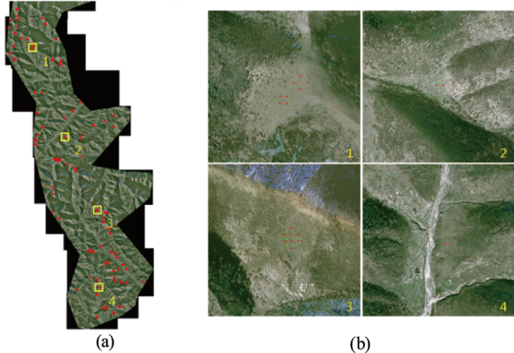
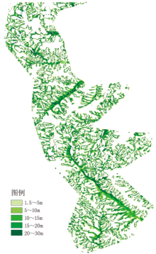
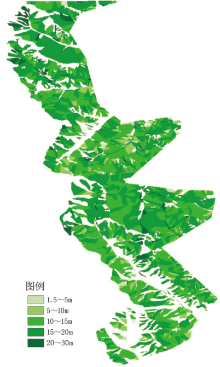
| [1] |
张巍巍, 冯仲科, 汪笑安 , 等. 基于TM影像的林木参数提取和树高估测[J]. 中南林业科技大学学报, 2013,33(9):27-31.
|
| [2] |
LY/T1955—2011,林地保护利用规划林地落界技术规程[S].
|
| [3] |
彭培胜, 王懿祥, 吴建强 . 基于无人机遥感影像的三维森林景观可视化[J]. 东北林业大学学报, 2013,41(6):61-65.
|
| [4] |
张园, 陶萍, 梁世祥 , 等. 无人机遥感在森林资源调查中的应用[J]. 西南林业大学学报, 2011,31(3):49-53.
|
| [5] |
周志强, 岳彩荣, 徐天蜀 , 等. 森林高度遥感估测研究综述[J]. 现代农业科技, 2012(2):198-203.
|
| [6] |
李德仁, 李明 . 无人机遥感系统的研究进展与应用前景[J]. 武汉大学学报, 2014,39(5):505-513.
|
| [7] |
冯家莉, 刘凯, 朱远辉 , 等. 无人机遥感在红树林资源调查中的应用[J]. 热带地理, 2015,35(1):35-42.
|
| [8] |
孔凡婕, 李晓兵, 白云晓 , 等. 基于GF-1 WFV影像的丰宁县植被地上碳储量估算[J]. 资源科学, 2016,38(6):1054-1064.
doi: 10.18402/resci.2016.06.05
|
| [9] |
贾秀鹏, 焦伟利, 李丹 . 基于SPOT5异轨立体像对提取DEM试验与精度评估[J]. 测绘信息与工程, 2006,31(2):32-34.
|
| [10] |
范兴旺, 翁永玲, 胡伍生 , 等. IRS-P5立体像对提取DEM及精度评价[J]. 遥感技术与应用, 2010,25(4):547-551.
|
| [11] |
蔡庆空, 蒋金豹, 张玲 , 等. ALOS-PRISM立体像对提取DEM的应用研究[J]. 测绘科学, 2014,39(1):70-73.
|
| [12] |
刘俊杰, 贾永红, 何保国 , 等. Geoeye-1卫星立体像对处理试验[J]. 地理空间信息, 2010,8(2):83-85.
|
| [13] |
丁辉, 姚安强 . 利用IKONOS立体像对提取DEM精度的实验[J]. 测绘科学, 2012,37(1):179-181.
|
| [14] |
陈庆华, 陈小艺 . 基于多角度卫星影像制作DSM,DEM数字产品的方法研究[J]. 测绘与空间地理信息, 2015,38(8):168-169.
|
| [15] |
卓莉, 黄信锐, 王芳 , 等. 基于高空间分辨率与立体像对遥感数据的建筑物三维信息提取[J]. 遥感技术与应用, 2013,28(6):1062-1068.
|
| [16] |
王佳, 冯仲科 . 航空数字摄影测量对林分立木测高及精度分析[J]. 测绘科学, 2011,36(6):77-79.
|
 ), 王雪军1, 刘明博2