| [1] |
冯仲科, 黄晓东, 刘芳. 森林调查装备与信息化技术发展分析[J]. 农业机械学报, 2015,46(9):257-265.
|
| [2] |
刘安兴. 森林资源年度检测理论与方法研究[D]. 南京:南京林业大学, 2006.
|
| [3] |
刘杰, 李卫正, 张青萍, 等. 基于小型UAV的森林公园正射影像制图分析——以上海滨江森林公园为例[J]. 西北林学院学报, 2016,31(2):213-218.
|
| [4] |
张园, 陶萍, 梁世祥, 等. 无人机遥感在森林资源调查中的应用[J]. 西南林业大学学报, 2011,31(1):49-53.
|
| [5] |
Garzon-Lopez C X, Bohlman S A, Olff H, et al. Mapping tropical forest trees using high-resolution aerial digital photographs[J]. Biotropica, 2013,45(3):308-316.
|
| [6] |
李宇昊. 无人机在林业调查中的应用实验[J].林业资源管理, 2007(4):70-73.
|
| [7] |
冯家莉, 刘凯, 朱远辉, 等. 无人机遥感在红树林资源调查中的应用[J]. 热带地理. 2015,35(1):35-42.
|
| [8] |
Bolognesi M, Furini A, Russo V, et al.Testing the low-cost RPAS potential in 3D cultural heritage reconstruction:The Achieves of The Photogramme[J]. Remote Sensing and Spatial Information Sciences[J], 2015,5(W4):229-235.
|
| [9] |
曹明兰, 张力小, 王强. 无人机遥感影像中行道树信息快速提取[J]. 中南林业科技大学报, 2016,36(10):89-93.
|
| [10] |
樊江川. 无人机航空摄影测树技术研究[D]. 北京:北京林业大学, 2014.
|
| [11] |
赵云景, 龚绪才, 杜文俊, 等. PhotoScan Pro软件在无人机应急航摄中的应用[J]. 国土资源感, 2015,27(4):179-182.
|
| [12] |
舒婷, 李卫正, 张青萍, 等. 基于小型无人机的三维实景公园数字建模——以南京羊山森林公园为例[J].建筑与文化, 2016(3):120-121.
|
| [13] |
赵明. Pix4D mapper软件在无人机航空摄影与工程地质调查中的数据处理[J]. 水电站设计, 2017,33(2):47-48.
|
| [14] |
Nakano K, Suzuki H, Tamino T, et al. On Fundamental Evaluation Using Uav Imagery and 3d Modeling Software[J].ISPRS-International Archives of the Photogrammetry,Remote Sensing and Spatial Information Sciences, 2016, XLI-B5:93-97.
|
| [15] |
Wang Y J. Application and Research of Pix4Dmapper in UAVAerophotography for Emergency Projection[J]. Geomatics & Spatial Information Technology, 2016.
|
| [16] |
孟鸣, 李靖琳, 沈玉成. 一种高效快速建立地物三维模型的方法——以大疆无人机和Pix4D软件实现[J]. 云南地理环境研究, 2016,28(4):1-7.
|
| [17] |
赵云景, 龚绪才, 杜文俊, 等. PhotoScan Pro软件在无人机应急航摄中的应用[J]. 国土资源遥感, 2015,27(4):179-182.
|
| [18] |
李秀全, 陈竹安, 张立亭. 基于Agisoft PhotoScan的无人机影像快速拼接在新农村规划中的应用[J].湖北农业科学, 2016(3):743-745.
|
| [19] |
Verhoeven G. Taking computer vision aloft-archaeological three-dimensional reconstructions from aerial photographs with photoscan[J]. Archaeological Prospection, 2011,18(1):67-73.
doi: 10.1002/arp.399
|
| [20] |
付仲杨. Agisoft Photoscan和Adobe Illustrator软件在田野考古绘图中的综合应用[J].四川文物, 2016(4):88-96.
|
| [21] |
张小宏, 赵生良, 陈丰田. Agisoft photoscan在无人机航空摄影影像数据处理中的应用[J].价值工程, 2013(20):230-231.
|
| [22] |
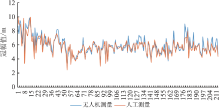
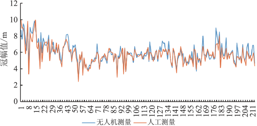
周艳飞, 张绘芳, 李霞, 等. 不同方法提取无人机影像树冠信息效果分析[J].新疆农业大学学报, 2014(3):231-235.
|