欢迎访问林业资源管理

林业资源管理 ›› 2017, Vol. 0 ›› Issue (2): 103-109.doi: 10.13466/j.cnki.lyzygl.2017.02.018

• 技术应用 • 上一篇    

小型无人机非测量相机在林业调查中的应用研究

孙志超1(), 杨雪清1(), 李超2   

  1. 1. 国家林业局调查规划设计院,北京 100714
    2. 北京大学 城市与环境学院,北京 100871
  • 收稿日期:2017-01-13 修回日期:2017-03-15 出版日期:2017-04-28 发布日期:2020-10-10
  • 通讯作者: 杨雪清
  • 作者简介:孙志超(1986-),女,山东人,硕士,主要从事林业遥感技术的研究与应用工作。 Email: sunzhichaook@foxmail.com

Application of Small Unmanned Aerial Vehicle with Non-measuring Camera in Forestry Investigation

SUN Zhichao1(), YANG Xueqing1(), LI Chao2   

  1. 1. Academy of Forest Inventory and Planning,State Forestry Administration,Beijing 10074,China
    2. Department of Ecology,College of Urban and Environmental Sciences,Peking University,Beijing 100871,China
  • Received:2017-01-13 Revised:2017-03-15 Online:2017-04-28 Published:2020-10-10
  • Contact: YANG Xueqing

摘要:

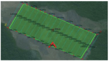
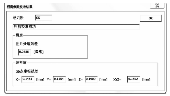
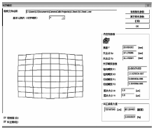
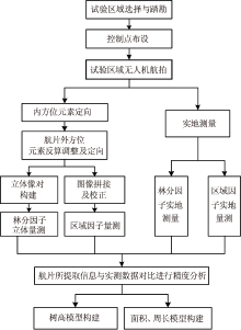
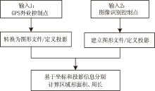
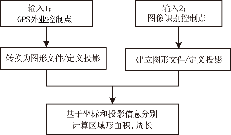
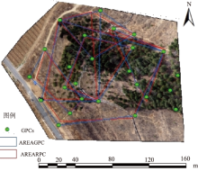
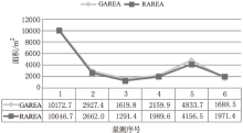
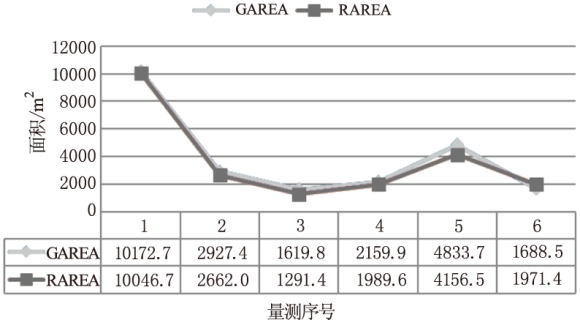
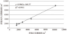
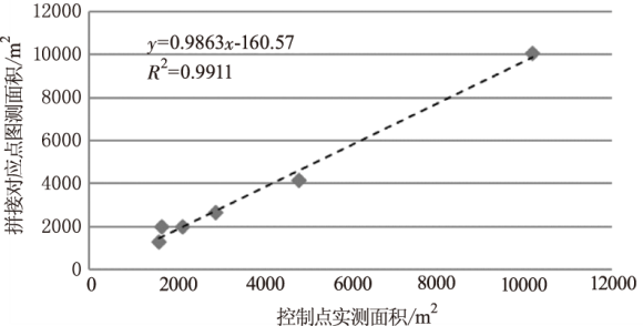
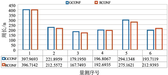
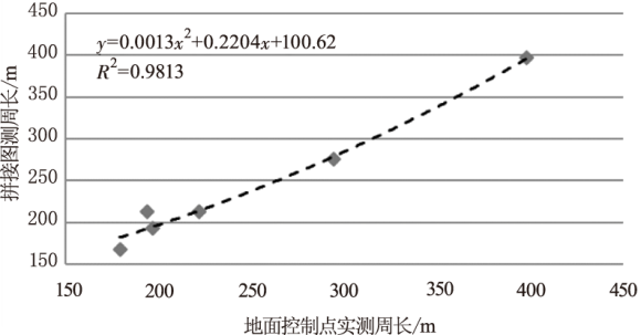
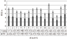
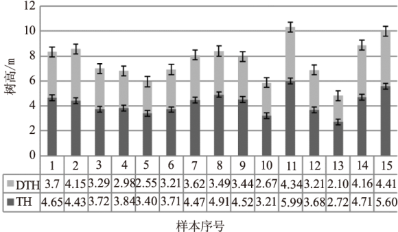
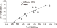
为提升林业调查的技术水平,研究小型无人机搭载非测量相机在林业调查中的应用技术。选择北京十三陵林场开展低空航拍试验,针对非测量相机的镜头畸变和小型无人机相机云台外方位元素误差较大的特点,分别通过相机检校算法和外方位元素逆向求解,进行内外方位元素定向,生成立体像对和正射影像;用地面控制点对相片整体进行几何精校正,采用3D量测工具测量立体区域树高,用地面控制点测量图像拼接区域面积和周长,用现地实测树高、面积和周长对图测结果进行检验和模型拟合。结果表明,通过适当的校正和调整,小型无人机搭载非测量相机基本能够满足林业调查对树高、面积及周长等的量测精度要求,应用前景广阔。

关键词: 无人机, 林业调查, 非量测相机, 树高, 面积

Abstract:

To enhance the technology for forestry investigation,our study focused on the application of small unmanned aerial vehicle (UAV) equipped with non-measuring camera in forestry investigation.In the study,we selected the Shisanling Forest Farm in Beijing as the study area to implement the test of airborne photographing.Moreover,intended for the characteristics of lens distortion in camera and large error of exterior orientation elements of the camera platform in UAV,we utilized a camera calibration algorithm and exterior orientation elements to inverse the accuracy exterior and interior orientation,and obtained the stereo images and orthophotos.In addition,the ground control points (GCPs) were used to carry on the geometric correction in the whole photo,and 3D measurement tools to measure the tree height in the three-dimensional area,and the GCPs to measure the area and perimeter of the mosaic area.Finally,the photo-measured results of tree height,area and perimeter were fitted to the field-measured results with empirical models,which also tested the photo-measured results.The results show that the small UAV equipped with non-measuring cameras can meet the accuracy requirements of the height,area and perimeter for the forestry surveying,if the device could be adjusted and calibrated properly.And it,therefore,has broad prospects of application in forest investigation.

Key words: unmanned aerial vehicle, forestry investigation, non-measurement camera, tree height, forest area

中图分类号: