欢迎访问林业资源管理

林业资源管理 ›› 2017, Vol. 0 ›› Issue (2): 58-64.doi: 10.13466/j.cnki.lyzygl.2017.02.011

• 科学研究 • 上一篇    下一篇

顾及植被季相节律的滨海湿地类型动态变化研究

王海龙1,2(), 刘雪惠1,2, 温小荣1,2(), 郜昌健1,2, 佘光辉1,2, 孟雪1,2, 李赟1,2   

  1. 1. 南京林业大学 南方现代林业协同创新中心,南京 210037
    2. 南京林业大学 林学院,南京 210037
  • 收稿日期:2016-12-07 修回日期:2017-04-19 出版日期:2017-04-28 发布日期:2020-10-10
  • 通讯作者: 温小荣
  • 作者简介:王海龙(1992-),男,安徽亳州人,在读硕士,主要研究方向:3S技术与森林资源动态监测。Email: 1224060531@qq.com
  • 基金资助:
    国家948计划项目(2013-4-63);南京林业大学科技创新基金项目(CX2011-24);江苏省林业三新工程(LYSX[2015]19);江苏高校优势学科建设工程自助项目(PAPD)

Dynnmic Changes of Coastal Wetland Types with Taking Seasonal Rhythms into Account

WANG Hailong1,2(), LIU Xuehui1,2, WEN Xiaorong1,2(), GAO Changjian1,2, SHE Guanghui1,2, MENG Xue1,2, LI Yun1,2   

  1. 1. South Modern Forestry Cooperative Research Center,Nanjing Forestry University,Nanjing 210037,China
    2. Forestry College of Nanjing Forestry University,Nanjing 210037,China
  • Received:2016-12-07 Revised:2017-04-19 Online:2017-04-28 Published:2020-10-10
  • Contact: WEN Xiaorong

摘要:

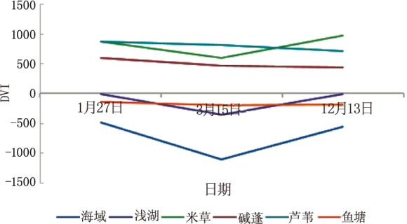
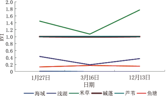
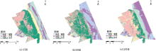
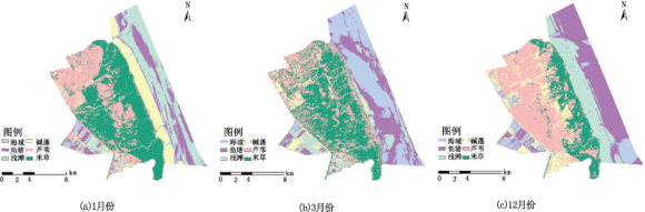
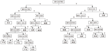
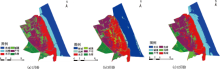
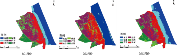
基于盐城国家级珍禽自然保护区核心区2014年3个月份的Landsat 8遥感影像及其矢量数据,采用基于CART算法的决策树分类方法提取研究区芦苇、碱蓬、米草、鱼塘、浅滩、海域等湿地信息,并分析2014年植被变化情况。其中采用植被指数NDVI,RVI,DVI时间序列光谱分析曲线获得湿地植被类型窗口期,通过各植被指数、第一主成分分量、缨帽变换、原始波段(红外、近红外)、非监督分类影像等因子构建时序因子集。结果表明:1)3—12月份为植被分类窗口期,芦苇、碱蓬、米草区分度最大;2)CART算法的决策树分类方法对盐城湿地植被区分度较好,3个月份影像分类总体精度分别为99.88%,99.18%和97.61%,Kappa系数分别为0.99,0.99和0.97;3)2014年间,芦苇的面积从61.69km 2增长到63.08km 2,米草从38.01km 2增加到44.78km 2,碱蓬从26.37km 2锐减到19.63km 2

关键词: 时间序列, 植被指数, 物候特征, CART 算法, 滨海湿地

Abstract:

Based on three months of Landsat8 remote sensing images and vector data of the core area of Yancheng national rare birds nature reserve and vector data in 2014,using CART-based decision tree classifier to extract phragmites,suaeda,spartina,fish ponds,mud flat,waters and wetlands information and then changes of vegetation are analyzed.Using vegetation index NDVI,RVI,DVI series spectrum curves to get a wetland vegetation type in the window period,through the vegetation index,the first principal component,tasseled Cap transformation,the original bands(red,near-infrared),unsupervised classification image,sequence subsets are built.Results showed that:1) The window period for vegetation classification is from March to December,phragmites,suaeda,Spartina discrimination of maximal order during this decision tree classification of remote sensing images for the data source can improve the accuracy of classification;2) CART-based decision tree classifier to Yancheng wetland vegetation and distinguish have good overall classification accuracy for 99.88%,99.18% and 97.61% and good Kappa coefficient for 0.99,0.99 and 0.97;3) In 2014,the area of phragmites grew from 61.69km 2 to 63.08km 2and spartina from 38.01km 2to 44.78km 2 while suaeda had fallen from 26.37km 2to 19.63km 2.

Key words: time series, vegetation index, phenological characteristics, CART algorithm, coastal wetland

中图分类号: