欢迎访问林业资源管理

林业资源管理 ›› 2017, Vol. 0 ›› Issue (1): 110-117.doi: 10.13466/j.cnki.lyzygl.2017.01.019

• 科学研究 • 上一篇    下一篇

北疆生态功能区降水气温时空变化及其与NDVI相关性分析

王计平1(), 郭仲军2(), 程复3, 张启斌4, 马欢4, 于一雷5   

  1. 1. 中国林业科学研究院 国家林业局盐碱地研究中心,北京 100091
    2. 新疆林科院森林生态研究所,乌鲁木齐 830000
    3. 水利部水土保持监测中心,北京 100055
    4. 北京林业大学 林学院,北京100083
    5. 中国林业科学研究院湿地研究所 湿地生态功能与恢复北京市重点实验室,北京 100091
  • 出版日期:2017-02-28 发布日期:2020-10-03
  • 通讯作者: 郭仲军
  • 作者简介:王计平(1978-),男,山西保德人,助研,博士,主要研究植被恢复、景观格局优化与生态过程模拟。Email:wjp_gis@163.com
  • 基金资助:
    国家重点研发计划项目“重度盐碱地资源化利用技术与模式”(2016YFC051403);国家林业局局本级项目“环渤海地区盐碱地资源可持续利用战略研究”(1691400100099)

Spatio-temporal Change in Precipitation and Surface Temperature and Their Relationships with NDVI of Different Ecological Function Zones in North Xinjiang

WANG Jiping1(), GUO Zhongjun2(), CHENG Fu3, ZHANG Qibin4, MA Huan4, YU Yilei5   

  1. 1. Research Center of Saline and Alkali Land of State Forestry Administration,CAF.,Beijing 100091,China
    2. Institute of Forest Ecology,Xinjiang Forestry Academy,Urumqi 830000,China
    3. Soil and Water Conservation Monitoring Center,Ministry of Water Resources,Beijing 100055,China
    4. College of Forestry,Beijing Forestry University,Beijing 100083,China
    5. Beijing Key Laboratory of Wetland Services and Restoration,Institute of Wetland Research,Chinese Academy of Forestry,100091 Beijing,China
  • Online:2017-02-28 Published:2020-10-03
  • Contact: GUO Zhongjun

摘要:

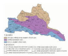
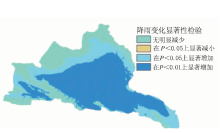
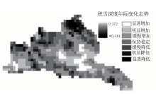
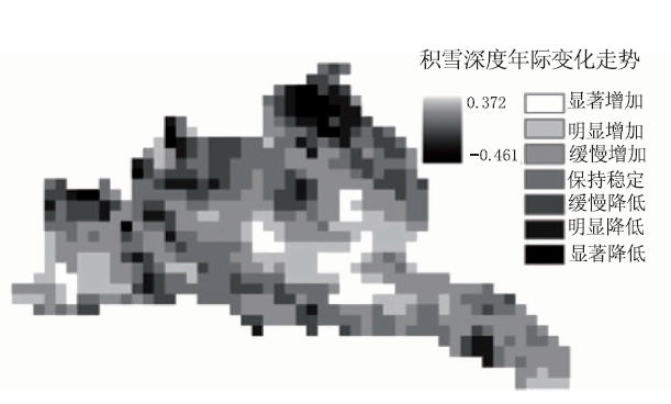
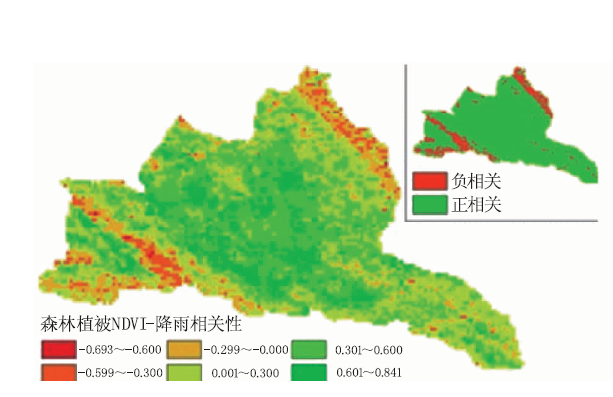
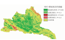
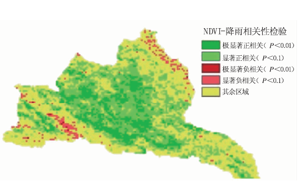
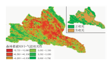
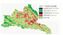
降水和气温是两个最重要的气候因子,也是影响植被分布和变化的主要因子之一。以多年平均降水、气温、NDVI、积雪深度等数据为基础,基于生态功能区划,分析了北疆不同气候要素变化及其与NDVI的变化相关关系。结果表明:北疆大部分地区趋向于湿润化,特别是准噶尔盆地中心区,降雨变化趋势线的斜率介于1.15~1.42之间;局部高海拔山区年平均降水量呈明显减低趋势,降雨变化趋势线斜率最低到-0.209;北疆整体有暖化趋势,且气温增加幅度从高山到低地表现出明显梯度,其变化趋势线斜率从高山处的2.04降低为盆地处的-0.044。北疆NDVI与年平均降水、温度变化密切相关,表现出明显的功能区划差异,应重视加强生态功能区划水平上的植被建设与调控。

关键词: NDVI时间序列数据集, 生态功能区, 空间变化, 气候要素, 相关分析

Abstract:

Precipitation and surface temperature are two most important climatic factors.They are also two main factors that affect the distribution and change of the vegetation.Based on the average annual precipitation,temperature,NDVI and snow depth data of many years,the changes in different climate factors and their correlation with NDVI were analyzed.The result shows that:most of the regions in north Xinjiang tend to be wetting,especially in the central area of the Junggar Basin,where the slope of the precipitation change is between 1.15 and 1.42;the annual average precipitation in the high altitude mountain area that only makes up 2% of the whole region decreases obviously,the sharpest decreasing slope of the precipitation change is -0.203;the overall temperature of north Xinjiang shows a warming trend,of which the slope of temperature increase shows a significantly gradient pattern from high mountains(2.04)to lowland(-0.044);NDVI is closely related to average annual rainfall and temperature variations.We should attach importance to strengthening the construction and management of vegetation on the scale of ecological function area.

Key words: time-series NDVI data, ecological function zone, spatio-temporal change, climatic factors, correlation analysis

中图分类号: