欢迎访问林业资源管理

林业资源管理 ›› 2021, Vol. 0 ›› Issue (3): 160-164.doi: 10.13466/j.cnki.lyzygl.2021.03.025

• 技术应用 • 上一篇    下一篇

无人机航拍影像在林木信息提取中的应用

孙玉江1(), 李凤涛2(), 陈香芹1, 张磊1, 杨宁1, 郑达1   

  1. 1.青岛市园林和林业综合服务中心,山东 青岛 266003
    2.青岛夏禾生物科技有限公司,山东 青岛266109
  • 收稿日期:2021-03-19 修回日期:2021-04-14 出版日期:2021-06-28 发布日期:2021-08-04
  • 通讯作者: 李凤涛
  • 作者简介:孙玉江(1976-),男,河南社旗人,高工,硕士,主要从事松材线虫病监测普查、防治和检疫方面的研究。Email: qdsfmail@163.com

Application of UAV Aerial Photo Data in Forest Information Extraction

SUN Yujiang1(), LI Fengtao2(), CHEN Xiangqin1, ZHANG Lei1, YANG Ning1, ZHENG Da1   

  1. 1. Qingdao Comprehensive Service Center of Landscape and Forestry,Qingdao,Shandong 266003,China
    2. Qingdao Xiahe Biological Technology Co.,Ltd,Qingdao,Shandong 266003,China
  • Received:2021-03-19 Revised:2021-04-14 Online:2021-06-28 Published:2021-08-04
  • Contact: LI Fengtao

摘要:

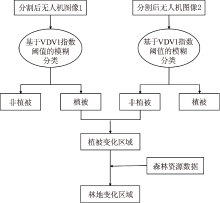
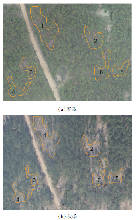
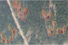
采用山东省青岛市崂山区沙子口街道2020年春、秋季的无人机松林航拍影像为数据源,借助ESP辅助工具获取了DOM影像的最佳分割尺度,构建了基于模糊分类的决策树,运用分水岭算法快速提取松林活立木数量变化信息,共提取出6个松树活立木变化较大区域,活立木减少数量205株,利用人工地面核查,实际松树活立木减少数量217株,该方法提取的数据总体精度约92.3%。研究表明,基于多期的无人机高分影像数据,能够快速准确地获取林木数量的变化情况。该法在森林资源调查、松材线虫病疫木除治监测及灾害评估中具有较大的应用推广价值,尤其在监测山高、路险的区域,很大程度上可以用于替代人工调查。

关键词: 无人机, 分割尺度, 决策树, 分水岭算法, 信息提取

Abstract:

In this study,the UAV images of pine forest in Shazikou Street,Laoshan District,Qingdao City,Shandong Province were captured in the spring and autumn of 2020.The optimal scale for the segmentation of DOM images was confirmed with ESP auxiliary tools.Decision trees for identifying the changing area were constructed using fuzzy classification.The watershed algorithm was used to rapidly extract the changes in the number of living trees in the pine forest.The results showed that the number of living trees decreased by 205 in 6 locations of the study area.Based on field surveys,217 trees were reduced,and the accuracy for detecting the changes of living trees was 92.3%.These results demonstrated that high-resolution UAV images could facilitate the rapid and accurate monitor of changes of trees in forests,thereby having great potential for forestry resource investigation,pinewood nematode disease monitoring and disaster assessment,especially for areas with high altitude and dangerous road,it can replace manual survey.

Key words: UAV, segmentation scale, decision tree, watershed algorithm, information extraction

中图分类号: