欢迎访问林业资源管理

林业资源管理 ›› 2021, Vol. 0 ›› Issue (2): 110-116.doi: 10.13466/j.cnki.lyzygl.2021.02.015

• 技术应用 • 上一篇    下一篇

基于无人机可见光影像的华山松人工林计测参数提取

袁梓健(), 舒清态(), 赵洪莹, 王柯人, 谭德宏   

  1. 西南林业大学 林学院,昆明 650224
  • 收稿日期:2020-12-18 修回日期:2021-03-27 出版日期:2021-04-28 发布日期:2021-06-03
  • 通讯作者: 舒清态
  • 作者简介:袁梓健(1993-),男,山东威海人,在读硕士,研究方向:3S在林业中的应用。Email: 86831200@qq.com
  • 基金资助:
    云南省教育厅科学研究基金项目(2020Y0403);国家自然科学基金项目(31860205);国家自然科学基金项目(31460194)

Extraction of the Measuring Parameters of Pinus armandii Man-Made Forest Based on Visible Image of UAV

YUAN Zijian(), SHU Qingtai(), ZHAO Hongying, WANG Keren, TAN Dehong   

  1. College of Forestry,Southwest Forestry University,Kunming 650224,China
  • Received:2020-12-18 Revised:2021-03-27 Online:2021-04-28 Published:2021-06-03
  • Contact: SHU Qingtai

摘要:

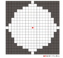
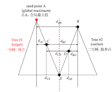
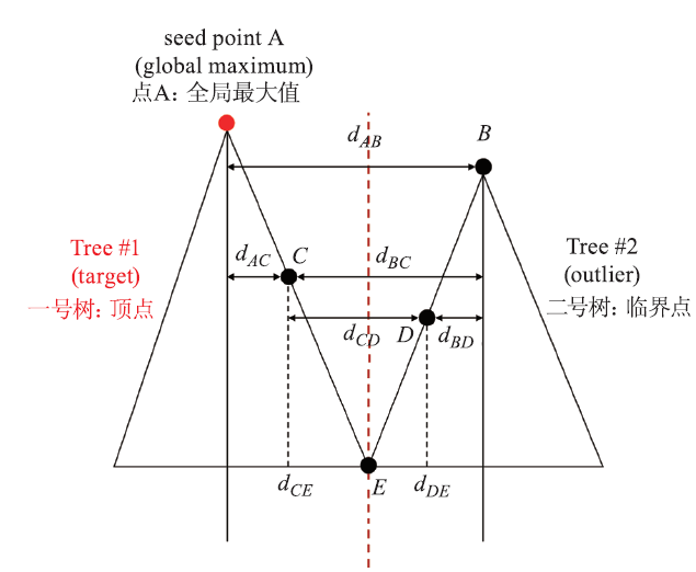
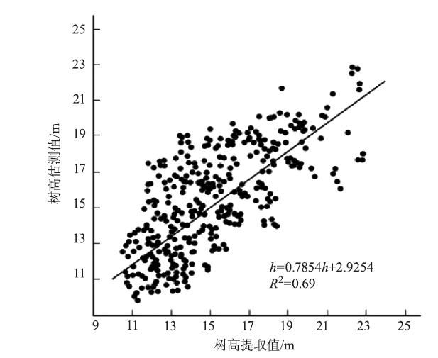
针对无人机在森林资源监测中的便携性特点,利用无人机RGB三波段影像进行森林计测参数(株数、树高及蓄积量)的提取及精度验证。以华山松人工林为研究对象,以无人机RGB影像为主要信息源,在前期进行5块0.08hm2华山松人工林标准地单木定位的基础上,采用冠层高度模型(CHM)最大值法和点云分割方法,提取华山松人工林计测参数,建立无人机RGB影像的华山松人工林单木二元材积模型。研究结果表明:1)采用CHM最大值分割法较点云分割方法精度高,单木株数分割精度分别为87.17%和80.79%;提取得到的树高与其地面实测所得树高的R2相比较,使用CHM方法,R2为0.71;而使用点云算法,R2为0.69。2)基于CHM最大值法提取的单株冠幅和树高所建立的二元材积模型,其决定系数(R2)为0.94,均方根误差(RMSE)为0.033 8m3;与基于云南省华山松人工林二元材积表的标准地实测蓄积量调查结果相比,基于无人机RGB数据的5块标准地蓄积量监测精度分别为79.72%,81.64%,83.57%,82.49%,80.28%,平均精度达81.54%。基于无人机RGB影像的华山松人工林在森林计测参数提取中,CHM最大值分割法优于点云分割,所建立的树高和冠幅二元材积模型,可为华山松单层人工林无人机遥感监测提供参考。

关键词: 无人机RGB影像, CHM分割, 点云分割, 森林计测参数, 华山松人工林

Abstract:

Thanks to the portability of unmanned aerial vehicles (UAV)in monitoring of forest resources,this paper uses RGB tri-band image of UAV to extract the forest measuring parameters (number of stems,height of tree and stand volume)and perform precision validation.Taking P.armandii man-made forest as research object,RGB image of UAV as main information source and based on five individual-tree positioning of 0.08hm2 P.armandii man-made forest sample plots in the early stage,this paper adopts canopy height model (CHM)maximum method and point cloud segmentation method to extract the measuring parameters of P.armandii and establishes a binary volume model of individual-tree in P.armandii man-made forest via RGB image of UAV.The results show that:(1)The results of individual-tree number and tree-height segmentation indicate that CHM maximum segmentation method has a higher precision than point cloud segmentation method,and the segmentation accuracy of the number of stems is 87.17% and 80.79%,respectively;the segmentation accuracy of the height of tree is 0.71 and 0.69,respectively.(2)The determination coefficient (R2)of the binary volume model established according to individual-tree crown breadth and tree-height extracted via CHM maximum method is 0.94,and its root-mean-square error (RMSE)is 0.033 8m3.The results are compared with those of the measured stock volume in standard land based on P.armandii of Yunnan Province binary volume table,the monitoring accuracy of stand volume of the five sample plots based on RGB data of UAV is 79.72%,81.64%,83.57%,82.49% and 80.28%,respectively,with the average accuracy reaching 81.54%.During the extraction of the measuring parameters of P.armandii man-made forest via RGB image of UAV,CHM maximum method is superior to point cloud segmentation method,and the binary volume model of tree height and crown breadth established by it can be used for UAV remote sensing in monitoring P.armandii monolayer man-made forest.

Key words: RGB image of UAV, CHM segmentation, point cloud segmentation, forest measuring parameter, P.armandii man-made forest

中图分类号: