欢迎访问林业资源管理

林业资源管理 ›› 2023, Vol. 0 ›› Issue (3): 38-45.doi: 10.13466/j.cnki.lyzygl.2023.03.006

• 科学研究 • 上一篇    下一篇

基于GEE与随机森林的象山港互花米草动态监测

梁立成1(), 傅晓强1, 张滨1, 程谷栒1, 李佐晖2()   

  1. 1.浙江省林业勘测规划设计有限公司,杭州 310020
    2.浙江省森林资源监测中心,杭州 310020
  • 收稿日期:2023-03-12 修回日期:2023-05-13 出版日期:2023-06-28 发布日期:2023-08-09
  • 通讯作者: 李佐晖(1983-),男,浙江杭州人,高级工程师,主要从事林业调查规划设计工作。Email: 675309800@qq.com
  • 作者简介:梁立成(1992-),男,浙江杭州人,工程师,主要从事湿地资源监测工作。Email: 492919413@qq.com

Dynamic Monitoring of Spartina alterniflora in Xiangshan Harbor Based on GEE and Random Forest

LIANG Licheng1(), FU Xiaoqiang1, ZHANG Bin1, CHENG Guxun1, LI Zuohui2()   

  1. 1. Zhejiang Forestry Survey Planning and Design Co.,Ltd,Hangzhou 310020,China
    2. Zhejiang Provincial Forest Resources Monitoring Center,Hangzhou 310020,China
  • Received:2023-03-12 Revised:2023-05-13 Online:2023-06-28 Published:2023-08-09

摘要:

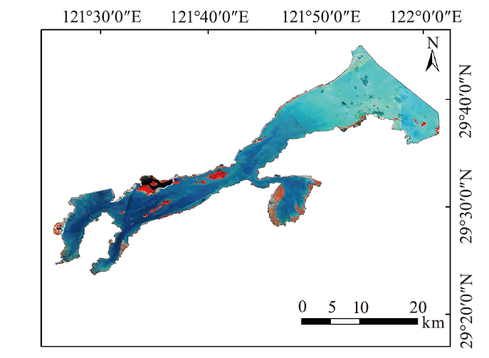
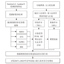
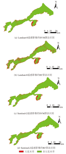
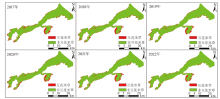
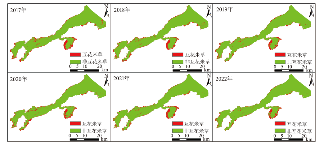
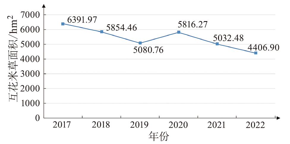
互花米草的大量入侵已危害到我国沿海海滨的生态安全,研究快捷、准确的互花米草识别算法,对于实现区域内互花米草动态监测尤为重要。利用谷歌地球引擎平台,以象山港为研究区,将151个互花米草和140个非互花米草的图斑作为训练数据集,从Sentinel-2遥感影像信息中提取NDVI,EVI,NDWI和BSI指数,将这些指数叠加到遥感影像数据中,利用支持向量机和随机森林等机器学习方法进行识别分类。通过对2017—2022年Sentinel-2遥感影像进行逐年识别分类,实现研究区内的互花米草动态监测。研究结果表明:相比支持向量机算法,随机森林算法对互花米草具有较高的识别精度,2022年的识别总体精度达到99.03%,Kappa系数0.978 7;同时,自2017年以来,象山港的互花米草面积逐渐减少,说明这期间采取的人为干预措施非常有效。象山港互花米草的动态监测和现状分析为互花米草的治理提供了定量的科学数据,对制定相关的防治措施具有重要的参考价值。

关键词: 互花米草, Google Earth Engine, 支持向量机, 随机森林, 遥感影像

Abstract:

The large-scale invasion of Spartina alterniflora has endangered the ecological security of China's coastal area.Therefore,studying a fast and accurate algorithm for identifying Spartina alterniflora is particularly important for achieving dynamic monitoring within the region.Taking Xiangshan harbor as a research zone in this study,151 Spartina alterniflora and 140 non-Spartina alterniflora land patches were used as the training data set on the GEE platform.The index of NDVI,EVI,NDWI and BSI were extracted from the Sentinel-2 remote sensing image band information,and these indices were added to the remote sensing image data.Machine learning methods such as Support Vector Machines and Random Forests were used for identification and classification.By identifying and classifying Sentinel-2 remote sensing images from 2017 to 2022,dynamic monitoring of Spartina alterniflora within the study area was achieved.The research results showed that compared with SVM,the RF method had higher recognition accuracy for identifying Spartina alterniflora,and the overall recognition accuracy in 2022 reached 99.03% with a Kappa coefficient of 0.978 7.At the same time,the experimental results showed that the area of Spartina alterniflora in Xiangshan harbor has gradually decreased since 2017,indicating that the artificial intervention measures taken during this period were very effective.The dynamic monitoring and status analysis of Spartina alterniflora in Xiangshan harbor provided quantitative scientific data for the management of Spartina alterniflora,and have important reference value for formulating relevant prevention and control measures.

Key words: Spartina alterniflora, Google Earth Engine, support vector machines, random forests, remote sensing image

中图分类号: