欢迎访问林业资源管理

林业资源管理 ›› 2021, Vol. 0 ›› Issue (2): 117-123.doi: 10.13466/j.cnki.lyzygl.2021.02.016

• 技术应用 • 上一篇    下一篇

基于Sentinel-2数据的塞罕坝机械林场落叶松人工林提取

李斌(), 李崇贵(), 李煜   

  1. 西安科技大学,西安 710054
  • 收稿日期:2021-01-27 修回日期:2021-03-30 出版日期:2021-04-28 发布日期:2021-06-03
  • 通讯作者: 李崇贵
  • 作者简介:李斌(1994-),男,陕西西安人,在读硕士,主要研究方向:林业遥感图像处理。Email: 554758017@qq.com
  • 基金资助:
    “十三五”国家重点研发计划项目(2017YFD0600400)

Research on Larch Extraction in Saihanba Mechanical Forest Farm Based on Sentinel-2 Data

LI Bin(), LI Chonggui(), LI Yu   

  1. Xi'an University of Science and Technology,Xi'an 710054,China
  • Received:2021-01-27 Revised:2021-03-30 Online:2021-04-28 Published:2021-06-03
  • Contact: LI Chonggui

摘要:

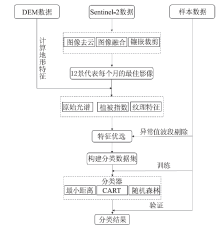
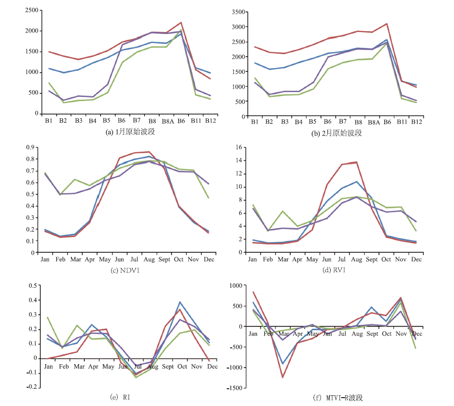
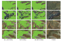
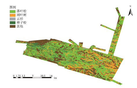
塞罕坝机械林场是我国大型国有林场,落叶松是林场森林经营管理的主体,快速准确提取落叶松人工林分布对林场的经营和管理具有重要意义。基于传统单机模式下的遥感影像分类耗时长、效率低下,随着地理信息大数据、云计算时代的到来,Google Earth Engine(GEE)作为地理空间分析平台的先行者,为遥感影像分类带来新的机遇。基于GEE平台,使用Sentinel-2数据实现塞罕坝机械林场主要树种遥感影像分类。通过对塞罕坝机械林场2019年全年309景Sentinel-2影像数据预处理,计算比值植被指数、纹理特征、地形特征,并对各特征进行优选,构建多特征分类数据集。以此为基础,比较最小距离法、决策树和随机森林分类器下的分类精度。结果表明,GEE相较于单机影像分类模式具有显著的优势;最小距离、决策树和随机森林分类器下的分类精度分别为80%,83%和92%,随机森林分类器更适合复杂的遥感分类任务。

关键词: Sentinel-2, 落叶松人工林, GEE云计算, 森林分类, 随机森林法

Abstract:

As larch is the major part for forest management,the rapid and accurate extraction of the distribution of the larch plantation is of great significance to the operation and management of the Saihanba forest farm,which is a large State-owned forest farm in China.Remote sensing image classification based on traditional stand-alone mode is time-consuming and inefficient,while with the advance of geographic information big data and cloud computing era,Google Earth Engine (GEE),the pioneer of geospatial analysis platform,brings new opportunities for remote sensing image classification.The research is based on the GEE platform and uses Sentinel-2 data to realize the image classification of main tree species of the Saihanba Mechanical Forest Farm.By preprocessing the Sentinel-2 image data of 309 sceneries of the Saihanba Mechanical Forest Farm in 2019,the ratio vegetation index,texture features and topographic features are calculated,and the selection is optimized to construct a multi-feature classification data set.Then,the study compares the classification accuracy under the minimum distance method,decision tree and random forest classifier to obtain the tree species classification map of the forest farm with the best classification accuracy.The results show that the GEE has significant advantages compared with the single-machine image classification mode; the classification accuracy under the minimum distance,decision tree and random forest classifier are 80%,83% and 92%,respectively.Random forest classifier is more suitable for complex remote sensing classification tasks.

Key words: Sentinel-2, artificial larch forest, GEE cloud calculation, forest classification, random forest method

中图分类号: