| [1] |
杨子祥, 王健敏, 陈晓鸣, 等. 松墨天牛在云南松树干的垂直分布研究[J]. 林业科学研究, 2010,23(4):607-611.
|
| [2] |
蒲智, 刘萍, 杨辽, 等. 城市绿地信息提取中的遥感影像阴影校正[J]. 北京林业大学学报, 2009,31(2):80-85.
|
| [3] |
徐伟燕, 孙睿, 金志凤. 基于资源三号卫星影像的茶树种植区提取[J].农业工程学报, 2016(S1):161-168.
|
| [4] |
王文泉, 陈永富, 李肇晨, 等. 基于面向对象的热带林分类方法研究[J]. 南京林业大学学报:自然科学版, 2017,41(3):117-123.
|
| [5] |
董德进, 周国模, 杜华强, 等. 6种地形校正方法对雷竹林地上生物量遥感估算的影响[J]. 林业科学, 2011,47(12):1-8.
doi: 10.11707/j.1001-7488.20111201
|
| [6] |
段四波, 阎广建. 山区遥感图像地形校正模型研究综述[J]. 北京师范大学学报:自然科学版, 2007,43(3):362-366.
|
| [7] |
高永年. 遥感影像地形校正理论基础与方法应用[M]. 北京: 科学出版社, 2013.
|
| [8] |
Wen J G, Qiang L. Parametrized BRDF for atmospheric and topographic correction and albedo estimation in jiangxi rugged terrain,China[J]. International Journal of Remote Sensing, 2009,30(11):2875-2896.
doi: 10.1080/01431160802558618
|
| [9] |
Wen J G, Liu Q, Liu Q H, et al. Scale effect and scale correction of land-surface albedo in rugged terrain[J]. International Journal of Remote Sensing, 2009,30(20):5397-5420.
doi: 10.1080/01431160903130903
|
| [10] |
Liu S H, Liu Q, Liu Q, et al. The angular and spectral kernel model for BRDF and albedo retrieval[J]. IEEE Journal of Selected Topics in Applied Earth Observations & Remote Sensing, 2010,3(3):241-256.
|
| [11] |
高永年, 张万昌. 遥感影像地形校正研究进展及其比较实验[J]. 地理研究, 2008,27(2):467-477.
|
| [12] |
Richter R, Kellenberger T, Kaufmann H. Comparison of topographic correction methods[J]. Remote Sensing, 2009,1(3):184-196.
doi: 10.3390/rs1030184
|
| [13] |
林起楠, 黄华国, 陈玲, 等. 陡峭山区影像的半经验地形校正[J]. 遥感学报, 2017,21(5):776-784.
|
| [14] |
刘时城, 温仲明, 陶宇, 等. 不同地形校正方法对刺槐林遥感提取的影响[J]. 北京林业大学学报, 2017,39(5):25-33.
|
| [15] |
穆悦, 安裕伦, 王喆, 等. 不同地形校正模型计算地形复杂山区地表反射率的对比[J]. 山地学报, 2014,32(3):257-266.
|
| [16] |
张超, 王人潮, 赵春江, 等. 山区高分辨率遥感影像地形辐射校正方法研究[J]. 浙江大学学报:农业与生命科学版, 2006,32(6):693-698.
|
| [17] |
闻建光, 柳钦火, 肖青, 等. 复杂山区光学遥感反射率计算模型[J]. 中国科学, 2008,38(11):1419-1427.
|
| [18] |
薛东剑, 李增元, 郑洁, 等. 利用DEM进行SAR图像模拟及地形辐射校正[J].测绘通报, 2017(7):14-17.
|
| [19] |
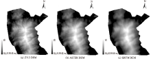
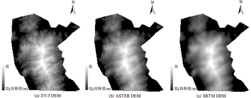
宿渊源, 张景发, 何仲太, 等. 资源卫星三号DEM数据在活动构造定量研究中的应用评价[J]. 国土资源遥感, 2015,27(4):122-130.
doi: 10.6046/gtzyyg.2015.04.19
|
| [20] |
Teillet P M, Guindon B, Goodenough D G. On the slope-aspect correction of multispectral scanner data[J]. Canadian Journal of Remote Sensing, 1982,8(2):1537-1540.
|
| [21] |
Civco D L. Topographic normalization of Landsat thematic mapper digital imagery[J]. Photogrammetric Engineering & Remote Sensing, 1989,55(1):135-43.
|
| [22] |
Soenen S A, Peddle D R, Coburn C A. SCS+C:a modified Sun-canopy-sensor topographic correction in forested terrain[J]. IEEE Transactions on Geoscience & Remote Sensing, 2005,43(9):2148-2159.
|
| [23] |
吕利利, 颉耀文, 董龙龙. 基于不同地形校正模型的影像反射率对比分析[J]. 遥感技术与应用, 2017,32(4):751-759.
|
| [24] |
丁一帆, 尤红建, 张浩, 等. 面向高分辨率遥感影像的地形辐射校正方法[J]. 北京航空航天大学学报, 2018,44(1):27-35.
|
 ), 陶欢2,3(