

Forest and Grassland Resources Research ›› 2024›› Issue (4): 70-77.doi: 10.13466/j.cnki.lczyyj.2024.04.008
• Scientific Research • Previous Articles Next Articles
ZENG Shuangbei1( ), ZHANG Dawei2, DU Zongyi1()
Received:2024-06-15
Revised:2024-08-10
Online:2024-08-28
Published:2025-04-18
CLC Number:
ZENG Shuangbei, ZHANG Dawei, DU Zongyi. Analysis of Changes in Land Use Landscape Pattern in Wenchuan County[J]. Forest and Grassland Resources Research, 2024, (4): 70-77.
Add to citation manager EndNote|Ris|BibTeX
URL: https://www.lyzygl.com.cn/EN/10.13466/j.cnki.lczyyj.2024.04.008

Fig.1
Elevation distributionof the study area
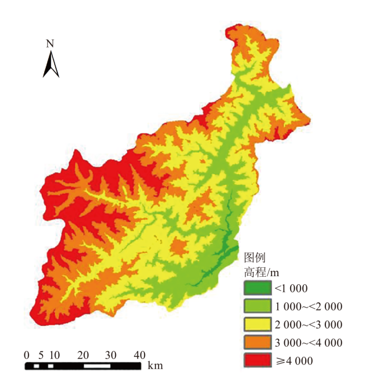
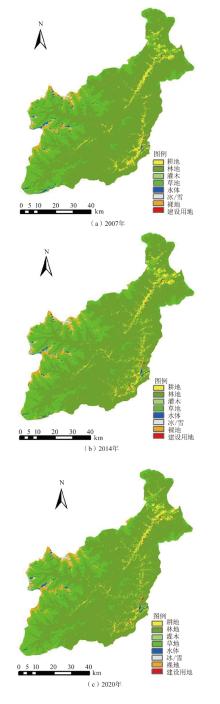
Fig.2
Spatial distribution of land use in different periods

Tab.1
Gradeassignment of land use degree
| 土地利用 类型 | 裸地、冰川和 永久积雪 | 林地、草地、 灌木、水体 | 耕地 | 建设 用地 |
|---|---|---|---|---|
| 分级指数 | 1 | 2 | 3 | 4 |
Tab.2
Changes of land use area in Wenchuan Countykm2
| 土地利用类型 | 2007年 | 2014年 | 2020年 | |
|---|---|---|---|---|
| 耕地 | 136.7 | 147.4 | 127.4 | |
| 林地 | 2 933.3 | 2 914.1 | 2 932.4 | |
| 建设用地 | 5.8 | 8.7 | 9.1 |
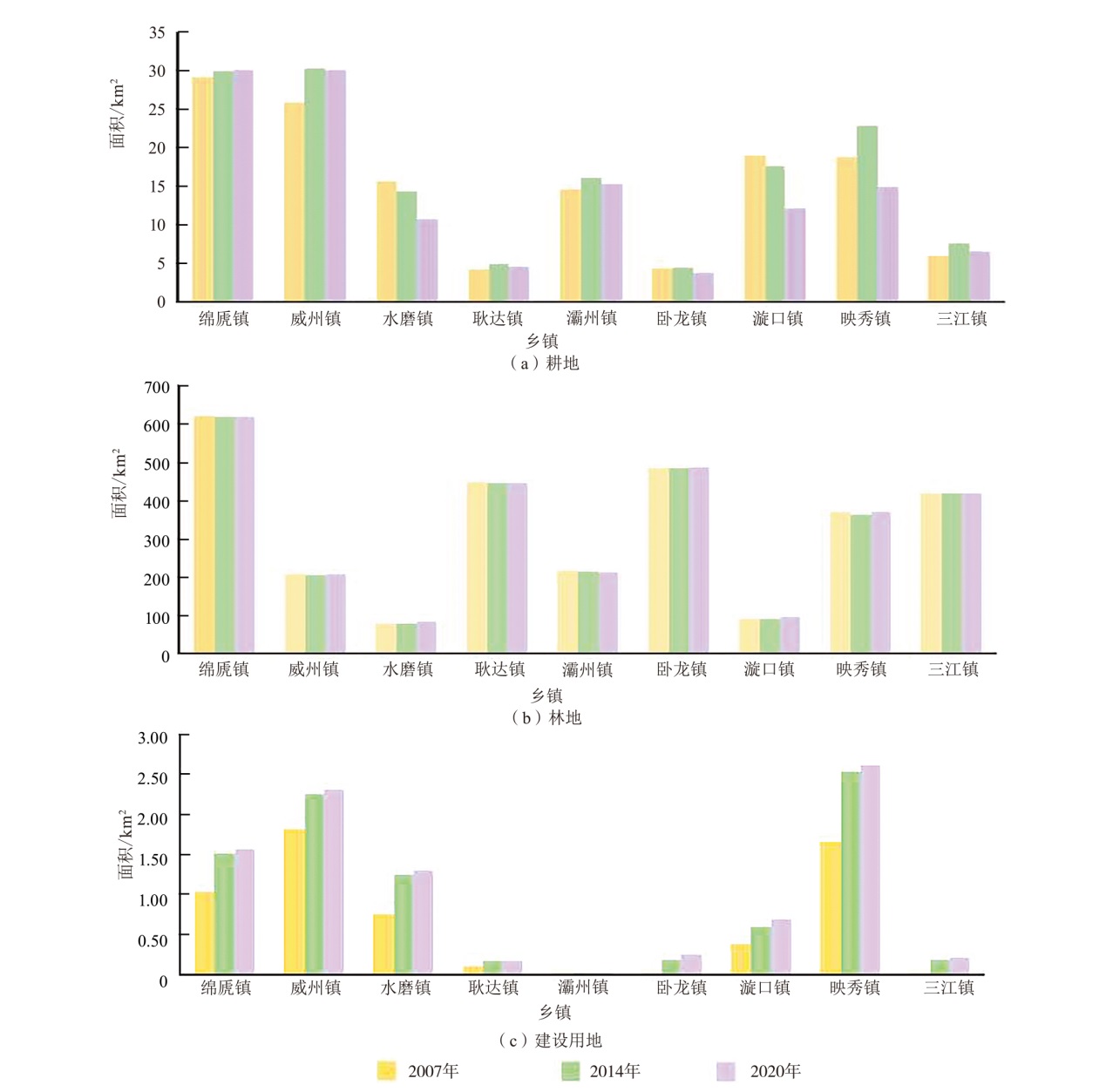
Fig.3
Statistical distribution map of typical land use types in the study area
Tab.3
Comprehensive index and rate of change of land use degree
| 乡镇 | 综合指数 | 变化率 | ||||
|---|---|---|---|---|---|---|
| 2007年 | 2014年 | 2020年 | 2007—2014年 | 2014—2020年 | ||
| 绵虒镇 | 203.71 | 203.80 | 203.60 | 0.04 | -0.10 | |
| 威州镇 | 210.40 | 212.13 | 212.06 | 0.82 | -0.03 | |
| 水磨镇 | 218.25 | 217.96 | 214.25 | -0.13 | -1.71 | |
| 耿达镇 | 190.79 | 190.05 | 188.94 | -0.39 | -0.59 | |
| 灞州镇 | 205.22 | 205.74 | 205.43 | 0.25 | -0.15 | |
| 卧龙镇 | 194.46 | 193.69 | 194.70 | -0.39 | 0.52 | |
| 漩口镇 | 216.58 | 215.77 | 211.02 | -0.38 | -2.20 | |
| 映秀镇 | 205.50 | 206.96 | 205.03 | 0.71 | -0.93 | |
| 三江镇 | 201.18 | 201.62 | 201.43 | 0.22 | -0.10 | |
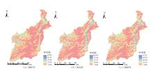
Fig.4
Spatial variation pattern of PD index from 2007 to 2020
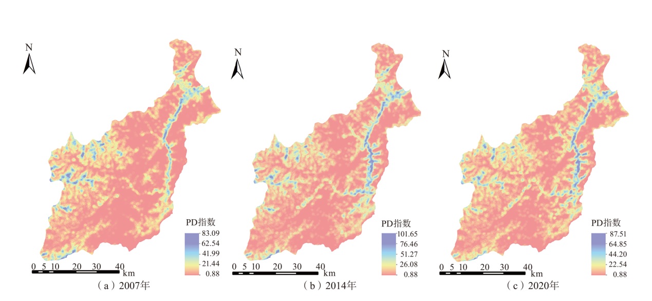
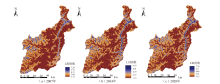
Fig.5
Spatial variation pattern of LSI from 2007 to 2020

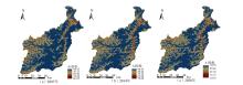
Fig.6
Spatial variation pattern of AI from 2007 to 2020

| [1] | 李鹤, 张平宇. 全球变化背景下脆弱性研究进展与应用展望[J]. 地理科学进展, 2011, 30(7):920-929. |
| [2] | 李玲. 基于多指标多尺度的全球地震与洪水综合人口暴露性研究[D]. 上海: 上海师范大学, 2023. |
| [3] | 沈菊. 综合多重现期的长江流域洪涝调节服务及其对土地利用变化的响应[D]. 上海: 上海师范大学, 2021. |
| [4] | 吴思多. 崇明生态岛未来土地利用变化与灾害风险暴露情景研究[D]. 上海: 华东师范大学, 2020. |
| [5] | ZHANG Bing, WU Yuanfeng, ZHAO Boya, et al. Progress and challenges in intelligent remote sensing satellite systems[J]. IEEE Journal of Selected Topics in Applied Earth Observations and Remote Sensing, 2022, 15:1814-1822. |
| [6] |
王权, 尤淑撑. 陆地卫星遥感监测体系及应用前景[J]. 测绘学报, 2022, 51(4):534-543.
doi: 10.11947/j.AGCS.2022.20210714 |
| [7] | 李晓恩, 周亮, 苏奋振, 等. InSAR技术在滑坡灾害中的应用研究进展[J]. 遥感学报, 2021, 25(2):614-629. |
| [8] | HAKIM W L, LEE C W. A review on remote sensing and GIS applications to monitor natural disasters in indonesia[J]. Korean Journal of Remote Sensing, 2020, 6:1303-1322. |
| [9] | VICENTE S, MARTIN V, VERENA F, et al. Integrated disaster risk management(IDRM):Elements to advance its study and assessment[J]. International Journal of Disaster Risk Science, 2023, 14(3):343-356. |
| [10] | DING Yong, WANG Pei, LIU Xiaoling, et al. Risk assessment of highway structures in natural disaster for the property insurance[J]. Natural Hazards, 2020, 104(3):2663-2685. |
| [11] | CHEN Ming, TANG Chuan, XIONG Jiang, et al. The long-term evolution of landslide activity near the epicentral area of the 2008 Wenchuan earthquake in China[J]. Geomorphology, 2020, 367:107317. |
| [12] | 陈怀亮, 徐祥德, 刘玉洁. 土地利用与土地覆盖变化的遥感监测及环境影响研究综述[J]. 气象科技, 2005(4):289-294. |
| [13] | CUI Peng, ZHUANG Jianqi, CHEN Xingchang, et al. Characteristics and countermeasures of debris flow in Wenchuan area after the earthquake[J]. Journal of Sichuan University(Engineering Science Edition), 2010, 42(5):10-19. |
| [14] | NATH B, NIU Z, SINGH R. Land use and land cover changes,and environment and risk evaluation of dujiangyan city(SW China) using remote sensing and GIS Techniques[J]. Sustainability, 2018, 10(12):4631. |
| [15] | YANG Wentao, WANG Ming, KERLE N, et al. Analysis of changes in post-seismic landslide distribution and its effect on building reconstruction[J]. Natural Hazards & Earth System Science, 2015, 15:817-825. |
| [16] | 康佳佳, 迪丽努尔·阿吉, 李平平, 等. 土地利用变化对博斯腾湖流域景观格局与生态系统服务价值的影响[J]. 水生态学杂志, 2024(6):1-14. |
| [17] | 任浩洋, 刘艳军, 王肖惠, 等. 快速城镇化地区土地利用景观格局演化及影响因素:以苏州市为例[J]. 东北师大学报(自然科学版), 2024, 56(1):143-153. |
| [18] | CHEN Yong, HU Jiupeng, PENG Fei. Seismological challenges in earthquake hazard reductions:Reflections on the 2008 Wenchuan earthquake[J]. Science Bulletin, 2018, 63(17):8. |
| [19] | PENG Yi, GU Xinbing, ZHU Xiaoting, et al. Recovery evaluation of villages reconstructed with concentrated rural settlement after the Wenchuan earthquake[J]. Natural Hazards, 2020, 104(1):139-166. |
| [20] | 徐新良, 江东, 庄大方, 等. 汶川地震灾害核心区生态环境影响评估[J]. 生态学报, 2008, 28(12):5899-5908. |
| [21] | 刘天雪, 王瑛, 陈宇, 等. 区域产业结构对灾后恢复韧性的影响:以汶川县和北川县为例[J]. 灾害学, 2024, 39(3):72-78. |
| [22] | YANG Jie, HUANG Xin. The 30 m annual land cover dataset and its dynamics in China from 1990 to 2019[J]. Earth System Science Data, 2021, 13(8):3907-3925. |
| [23] | 张富刚. 土地空间利用分析及土地利用程度评价研究[D]. 北京: 中国农业大学, 2005. |
| [24] | WANG Jun, WANG Zhihua, CHENG Hongbin, et al. Land cover changing pattern in pre-and post-earthquake affected area from remote sensing data:A case of Lushan County,Sichuan Province[J]. Land, 2022, 11(1205):1-24. |
| [25] | 布仁仓, 胡远满, 常禹, 等. 景观指数之间的相关分析[J]. 生态学报, 2005,(10):2764-2775. |
| [26] | PENG J, WANG Y, YE M, et al. Effects of land-use categorization on landscape metrics:A case study in urban landscape of Shenzhen,China[J]. 2007, 28(21):4877-4895. |
| [27] | KANG Junmei, SUI Lichun, YANG Xiaomei, et al. Spatial pattern consistency among different remote-sensing land cover datasets:A case studyin northern laos[J]. ISPRS International Journal of Geo-Information, 2019, 8(201):3-22. |
| [1] | CAI Yingli, ZHU Hongge. Research on Forest Loss Assessment Based on Multi-Source Datasets [J]. Forest and Grassland Resources Research, 2024, 0(6): 27-34. |
| [2] | YE Danni, YAO Manqing, FU Hong. Analysis of Ecological Landscape Pattern Changes in Gongga Mountain National Nature Reserve From 1996 to 2022 [J]. Forest and Grassland Resources Research, 2024, 0(5): 138-147. |
| [3] | WANG Tingqin, CHEN Zimeng, CHENG Linsong, ZHAO Zheng, XIA Jianxin. The Ecosystem Service Value and Changes of in the Mu Us Sandy Land [J]. Forest and Grassland Resources Research, 2024, 0(4): 113-125. |
| [4] | XIONG Ke, XING Yuanjun, HE Xiaofeng, TANG Lin, LU Hongwang. Remote Sensing Estimation of Forest AGB Based on KNN Algorithm [J]. Forest and Grassland Resources Research, 2024, 0(3): 106-112. |
| [5] | AN Da, WANG Haibing, BAI Yunfei, LI Siqi, ZHANG Xue, XU Guangfu. Spatial Distribution Patterns and Landscape Characteristics of Caragana korshinskii Groves in the Kubuqi Desert [J]. Forest and Grassland Resources Research, 2024, 0(2): 43-50. |
| [6] | HAO Jun, LYU Kangting, HU Tianqi, WANG Yunge, XU Gang. Remote Sensing Inversion of Mangrove Biomass Based on Machine Learning [J]. Forest and Grassland Resources Research, 2024, 0(1): 65-72. |
| [7] | ZHU Zan, WANG Yongjun, WANG Jianqi, XU Yulan, QIU Xinqi, WAN Xi. Construction of a Carbon Storage Measurement Model for Eucalyptus Canopy in Guangxi Based on Drone Oblique Photography [J]. Forest and Grassland Resources Research, 2024, 0(1): 88-94. |
| [8] | YUAN Yuan, SHENG Yan, LIU Linfu, WANG Shuo, LI Juan, AN Li. Spatial-Temporal Evolution Characteristics and Driving Influence Mechanism of Habitat Quality in Kuye River Basin [J]. Forest and Grassland Resources Research, 2023, 0(6): 67-74. |
| [9] | REN Xiaoqi, HOU Peng, CHEN Yan. Advances in Remote Sensing Retrieval of Forest Aboveground Biomass [J]. Forest and Grassland Resources Research, 2023, 0(6): 146-158. |
| [10] | JIAO Quanjun, ZHENG Yanfeng, HUANG Wenjiang, ZHANG Bing, ZHANG Heyi, SHI Yimeng, WU Fayun, FU Anmin. Detection of Discolored Trees Caused by Pine Wilt Disease Based on Vegetation Index Method Using Terrestrial Ecosystem Carbon Inventory Satellite Data [J]. FOREST RESOURCES WANAGEMENT, 2023, 0(4): 123-131. |
| [11] | ZOU Weimin, CHEN Chao, HUANG Lei, SONG Meixuan, LI Xuejian, DU Huaqiang. Geographic Weighted Regression Model Combined with Remote Sensing for Estimating Forest Aboveground Carbon Storage of Songyang County [J]. FOREST RESOURCES WANAGEMENT, 2023, 0(4): 132-140. |
| [12] | CAO Yili, ZHANG Xueli, LYU Gang, AN Yuning, CHI Linlin, LIU Yang. Study on Potassium Release Characteristics of Aeolian Sandy Soil Under Different Land Use Patterns in Zhanggutai,Liaoning Province [J]. FOREST RESOURCES WANAGEMENT, 2023, 0(4): 161-168. |
| [13] | LIANG Licheng, FU Xiaoqiang, ZHANG Bin, CHENG Guxun, LI Zuohui. Dynamic Monitoring of Spartina alterniflora in Xiangshan Harbor Based on GEE and Random Forest [J]. FOREST RESOURCES WANAGEMENT, 2023, 0(3): 38-45. |
| [14] | JIN Yu, WANG Juan, YANG Yue, YANG Xiongwei, MA Huimin. Impacts of Land Use Changes on the Habitat of Asian Elephants in Simao District of Yunnan [J]. FOREST RESOURCES WANAGEMENT, 2023, 0(3): 46-55. |
| [15] | ZHOU Mei, LI Chungan, YANG Chengling, LI Zhen. Experiments on Estimating Planted Forest Inventory Attributes Based on UAV-LiDAR Data [J]. FOREST RESOURCES WANAGEMENT, 2023, 0(3): 90-97. |
| Viewed | ||||||
|
Full text |
|
|||||
|
Abstract |
|
|||||