| [1] |
CHEN Tao, BAO Anming, JIAPAER Guli, et al. Disentangling the relative impacts of climate change and human activities on arid and semiaridgrasslands in Central Asia during 1982—2015[J]. Science of the Total Environment, 2019, 653:1311-1325.
doi: 10.1016/j.scitotenv.2018.11.058
|
| [2] |
REN Yu, ZHANG Bo, CHEN Xidong, et al. Analysis of spatial-temporal patterns and driving mechanisms of land desertification in China[J]. Science of the Total Environment, 2024, 909:168429.
|
| [3] |
李晶晶, 闫庆武, 胡苗苗基于地理加权回归模型的能源“金三角”地区植被时空演变及主导因素分析[J]. 生态与农村环境学报, 2018, 34(8):700-708.
|
| [4] |
刘二燕, 赵媛媛, 周蝶, 等. 科尔沁-浑善达克沙地2000—2020 年土地沙化时空变化格局[J]. 中国沙漠, 2024, 44(4):46-56.
doi: 10.7522/j.issn.1000-694X.2024.00040
|
| [5] |
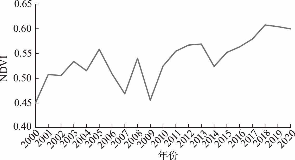
于静, 高亚敏, 付铭. 科尔沁草原NDVI时空变化特征及其对气候的响应[J]. 中国草地学报, 2020, 42(6):82-90.
|
| [6] |
杜云, 喇赟娥, 哈斯巴干. 基于Landsat数据的科尔沁沙地土地覆被变化分析[J]. 红外, 2020, 41(6):30-41.
|
| [7] |
吕家欣, 李秀芬, 郑晓, 等. 近40 年科尔沁沙地植被时空变化及其驱动力[J]. 生态学杂志, 2020, 39(5):1399-1408.
|
| [8] |
张丽, 张昱鑫. 近38年科尔沁沙地NDVI 时空演化[J]. 吉林师范大学学报(自然科学版), 2022, 43(2):134-140.
|
| [9] |
内蒙古自治区林业和草原局. 对自治区十三届人大六次会议第445号建议的答复[EB/OL].(2022-09-30)[2025-02-28]. https://lcj.nmg.gov.cn/xxgkzl/fdzdgknr/jytabl/202209/t20220930_2144511.html.
|
| [10] |
高锡林. 内蒙古林业生态建设技术与模式[M]. 北京: 中国林业出版社, 2008
|
| [11] |
李爱敏, 韩致文, 黄翠华, 等. 21 世纪初科尔沁沙地沙漠化程度变化动态监测[J]. 中国沙漠, 2007, 27(4):546-551.
|
| [12] |
红格尔. 近100 年科尔沁沙地土地沙漠化时空变化研究[D]. 呼和浩特: 内蒙古师范大学, 2007.
|
| [13] |
彭守璋. 中国1 km分辨率逐月降水量数据集(1901-2023)[DB/OL]. 国家青藏高原科学数据中心[2025-02-28].2020.https://doi.org/10.5281/zenodo.3114194.
|
| [14] |
YANG Jie, HUANG Xin. The 30 m annual land cover dataset and its dynamics in China from 1990 to 2019[J]. Earth System Science Data, 2021, 13(8):3907-3925.
doi: 10.5194/essd-13-3907-2021
|
| [15] |
于世勇, 徐前, 于晓斐. 2005—2020 年北京地区植被覆盖变化分析[J]. 林业资源管理, 2023(3):98-104.
|
| [16] |
李红, 李德志, 宋云, 等. 快速城市化背景下上海崇明植被覆盖度景观格局分析[J]. 华东师范大学学报:自然科学版, 2009(6):89-100.
|
| [17] |
贾宝全, 邱尔发, 张红旗. 基于归一化植被指数的西安市域植被变化[J]. 林业科学, 2012, 48(10):6-12.
|
| [18] |
中国科学院自然区划工作委员会, 中国气候区划[M]. 北京: 科学出版社, 1959.
|
| [19] |
赵珍珍, 冯建迪. 1980—2016 年科尔沁沙地景观时空格局演变特征分析[J]. 山东理工大学学报(自然科学版), 2020, 34(2):24-30.
|
| [20] |
通辽市2021年国民经济和社会发展统计公报[EB/OL].(2022-03-15)[2025-02-28]. https://tjj.tongliao.gov.cn/zjtj/sjcx/tjgb/202203/t20220315_841382.html.
|
| [21] |
毛德华, 王宗明, 宋开山, 等. 东北多年冻土区植被NDVI 变化及其对气候变化和土地覆被变化的响应[J]. 中国环境科学, 2011, 31(2):283-292.
|
| [22] |
韩贵锋. 中国东部地区植被覆盖的时空变化及其人为因素的影响研究[D]. 上海: 华东师范大学, 2007.
|
 ), 孙志超, 慈雪伦, 闫嘉豪