欢迎访问林业资源管理

林业资源管理 ›› 2018, Vol. 0 ›› Issue (1): 72-79.doi: 10.13466/j.cnki.lyzygl.2018.01.011

• 科学研究 • 上一篇    下一篇

城镇化背景下洱海上游土地利用演变过程分析

牛晓花(), 张超(), 余哲修, 周文娇, 黄田   

  1. 西南林业大学,昆明 650224
  • 收稿日期:2017-11-13 修回日期:2017-12-19 出版日期:2018-02-28 发布日期:2020-09-27
  • 通讯作者: 张超
  • 作者简介:牛晓花(1994-),女,山西长治人,在读硕士,从事林业遥感研究。Email:1158807508@qq.com
  • 基金资助:
    国家自然科学基金项目“基于高光谱耦合建模的干旱遥感反演技术”(31460195);国家自然科学基金项目“典型高原湖滨湿地植被高光谱遥感反演及时空演变过程”(31660236)

Analysis on Land Use Evolution Process in the Upper Reaches of Erhai under the Background of Urbanization

NIU Xiaohua(), ZHANG Chao(), YU Zhexiu, ZHOU Wenjiao, HUANG Tian   

  1. Southwest Forestry University,Kunming 650224,China
  • Received:2017-11-13 Revised:2017-12-19 Online:2018-02-28 Published:2020-09-27
  • Contact: ZHANG Chao

摘要:

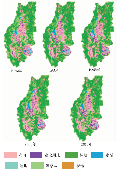
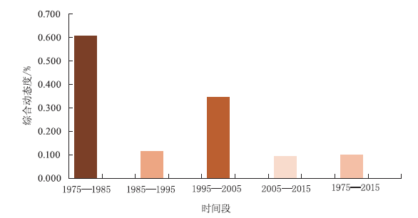
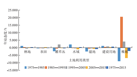
近年来,洱海流域社会经济发展迅速,城镇化进程加快,土地利用发生了较大变化。研究长时间序列洱海上游的土地利用演变过程,分析其与城镇化进程的耦合关系,具有重要意义。以洱海上游1975,1985,1995,2005和2015年遥感影像为基础数据,提取了各时期土地利用斑块信息,计算了土地利用转移矩阵,借助土地利用动态度模型、信息熵模型和分形模型,定量描述和分析了洱海上游土地利用的演变过程。结果表明:1)近40年间,洱海上游以林地、农田和灌草丛为优势地类,建设用地面积呈持续增加趋势,整体上土地利用综合程度处于中等水平;2)转移变化方面,主要以灌草丛的转出和建设用地的转入为典型特征,单一类型的动态度变化较小,其中建设用地的动态度变化较为明显,其面积处于增加趋势;3)洱海上游1975—2015年间的土地利用斑块信息熵、均衡度及稳定性亦发生了相应变化。分析研究城镇化背景下洱海上游土地利用演变特征,对于提升土地集约化程度,合理规划管理土地资源,科学制定经济发展政策,促进土地的科学与可持续利用,加快城镇可持续发展具有重要的指导意义。

关键词: 城镇化, 土地利用动态度, 信息熵, 分维数, 洱海上游

Abstract:

In recent years,the social economic development of Erhai basin has been rapid,the process of urbanization has been accelerated,and the land use has been changed greatly.It is of great significance to study the long-term evolution of land use in the upper reaches of Erhai and to analyze its correlation with urbanization.Based on the remote sensing images of the upper reaches of Erhai in 1975,1985,1995,2005 and 2015,the land use patch information of each period was extracted and the land use transfer matrix was calculated.With the help of the dynamic model of land use,information entropy model and fractal model,the evolution of land use in the upper reaches of Erhai was quantitatively described and analyzed.The results show:(1) In the recent 40 years,the forest land,farmland and shrub-grassland in the upper reaches of Erhai were the dominant land.The area of the construction land continued to increase,and the overall level of land use is at a moderate level.(2) In terms of transfer change,the main features are the outflow of shrub-grassland and the transfer of construction land.The change of dynamic degree of single land use type is small,of which the dynamic change of construction land is obvious and the area is in an increasing trend.The land use system is characterized by the outflow of shrubs and the transfer of construction land.Single dynamic degree change is small,the dynamic degree of the construction is obvious and the area is increasing.(3) Information entropy,equilibrium and stability of land use patches in the upper reaches of Erhai also changed correspondingly during the period from 1975 to 2015.Analyzing the evolution of land use in the upper reaches of Erhai under the background of urbanization can provide an important guiding significance for enhancing the degree of land intensification,planning and managing land resources reasonably,formulating economic development policies scientifically,promoting land science and sustainable utilization,and accelerating the sustainable development of towns.

Key words: urbanization, land use dynamic degree, information entropy, fractal dimension, upper reaches of Erhai

中图分类号: