| [1] |
吕宪国, 邹元春. 中国湿地研究[M]. 长沙: 湖南教育出版社, 2017.
|
| [2] |
董婵, 黄英豪, 闵凡路. 湿地植物与生态环境[M]. 天津: 天津科学技术出版社. 2014.
|
| [3] |
李旭, 谢永宏, 黄继山, 等. 湿地植被格局成因研究进展[J]. 湿地科学, 2009, 7(3):280-288.
|
| [4] |
郭柯, 方精云, 王国宏, 等. 中国植被分类系统修订方案[J]. 植物生态学报, 2020, 44(2):111-127.
doi: 10.17521/cjpe.2019.0271
|
| [5] |
Roughgarden J, Running S W, Matson P A. What does remote sensing do for ecology?[J]. Ecology, 1991, 72(6):1918-1922.
doi: 10.2307/1941546
|
| [6] |
Ozesmi S L, Bauer M E. Satellite remote sensing of wetlands[J]. Wetlands ecology and management, 2002, 10(5):381-402.
doi: 10.1023/A:1020908432489
|
| [7] |
Schmidt K S, Skidmore A K, Kloosterman E H, et al. Mapping coastal vegetation using an expert system and hyperspectral imagery[J]. Photogrammetric Engineering & Remote Sensing, 2004, 70(6):703-715.
|
| [8] |
Szantoi Z, Escobedo F, Abd-Elrahman A, et al. Analyzing fine-scale wetland composition using high resolution imagery and texture features[J]. International Journal of Applied Earth Observation and Geoinformation, 2013, 23:204-212.
doi: 10.1016/j.jag.2013.01.003
|
| [9] |
闫利, 江维薇. 多光谱遥感影像植被覆盖分类研究进展[J]. 国土资源遥感, 2016, 28(2):8-13.
|
| [10] |
张强. 湿地植被遥感分类研究进展[J]. 世界林业研究, 2019, 32(3):49-54.
|
| [11] |
谭衢霖, Steve Johansen. 基于像元和对象分类的城区植被高分辨率遥感制图比较研究[J]. 应用基础与工程科学学报, 2011, 19(3):441-448.
|
| [12] |
Johansen K, Coops N C, Gergel S E, et al. Application of high spatial resolution satellite imagery for riparian and forest ecosystem classification[J]. Remote Sensing of Environment, 2007, 110(1):29-44.
doi: 10.1016/j.rse.2007.02.014
|
| [13] |
Gilmore M S, Wilson E H, Barrett N, et al. Integrating multi-temporal spectral and structural information to map wetland vegetation in a lower Connecticut River tidal marsh[J]. Remote Sensing of Environment, 2008, 112(11):4048-4060.
doi: 10.1016/j.rse.2008.05.020
|
| [14] |
杨盼盼. 基于高分辨率遥感影像纹理特征的面向对象植被分类方法研究[D]. 昆明: 云南师范大学, 2017.
|
| [15] |
Carle M V, Wang L, Sasser C E. Mapping freshwater marsh species distributions using WorldView-2 high-resolution multispectral satellite imagery[J]. International journal of remote sensing, 2014, 35(13):4698-4716.
doi: 10.1080/01431161.2014.919685
|
| [16] |
Bhatnagar S, Gill L, Regan S, et al. Mapping vegetation communities inside wetlands using Sentinel-2 imagery in Ireland[J/OL]. International Journal of Applied Earth Observation and Geoinformation, 2020, 88:102083.(2020-02-14)[2022-08-23]. https://www.sciencedirect.com/science/article/pii/S0303243419308359?via%3Dihub.
doi: 10.1016/j.jag.2020.102083
|
| [17] |
Yeo S, Lafon V, Alard D, et al. Classification and mapping of saltmarsh vegetation combining multispectral images with field data[J/OL]. Estuarine,Coastal and Shelf Science, 2020, 236:106643.(2020-02-17)[2022-08-23]https://www.sciencedirect.com/science/article/abs/pii/S027277141930232X.
|
| [18] |
Ju Y, Bohrer G. Classification of wetland vegetation based on NDVI time series from the HLS dataset[J/OL]. Remote Sensing, 2022, 14(9):2107.(2022-04-27)[2022-08-25]https://www.mdpi.com/2072-4292/14/9/2107.
|
| [19] |
Lou Peiqing, Fu Bolin, He Hongchang, et al. An optimized object-based random forest algorithm for marsh vegetation mapping using high-spatial-resolution GF-1 and ZY-3 data[J/OL]. Remote Sensing, 2020, 12(8):1270.(2022-04-17)[2022-08-25]https://www.mdpi.com/2072-4292/12/8/1270.
|
| [20] |
谢锦莹, 丁丽霞, 王志辉, 等. 基于FCN与面向对象的滨海湿地植被分类[J]. 林业科学, 2020, 56(8):98-106.
|
| [21] |
刘尚武. 青海植物志[M]. 青海: 青海人民出版社,1996.
|
| [22] |
金伊丽, 王皓言, 魏临风, 等. 青藏高原植物群落样方数据集[J]. 植物生态学报, 2022, 46(7):846-854.
doi: 10.17521/cjpe.2022.0174
|
| [23] |
GB/T 21010-2017,土地利用现状分类[S].
|
| [24] |
刘瑞清, 李加林, 孙超, 等. 基于Sentinel-2遥感时间序列植被物候特征的盐城滨海湿地植被分类[J]. 地理学报, 2021, 76(7):1680-1692.
doi: 10.11821/dlxb202107008
|
| [25] |
邹文涛, 张怀清, 鞠洪波, 等. 基于QUEST树的高寒湿地植被覆盖类型遥感分类研究[J]. 中南林业科技大学学报, 2011, 31(12):138-144.
|
| [26] |
张学儒, 刘林山, 张镱锂, 等. 基于ENVI ZOOM面向对象的高海拔灌丛植被提取:以定日县为例[J]. 地理与地理信息科学, 2010, 26(4):104-108.
|
| [27] |
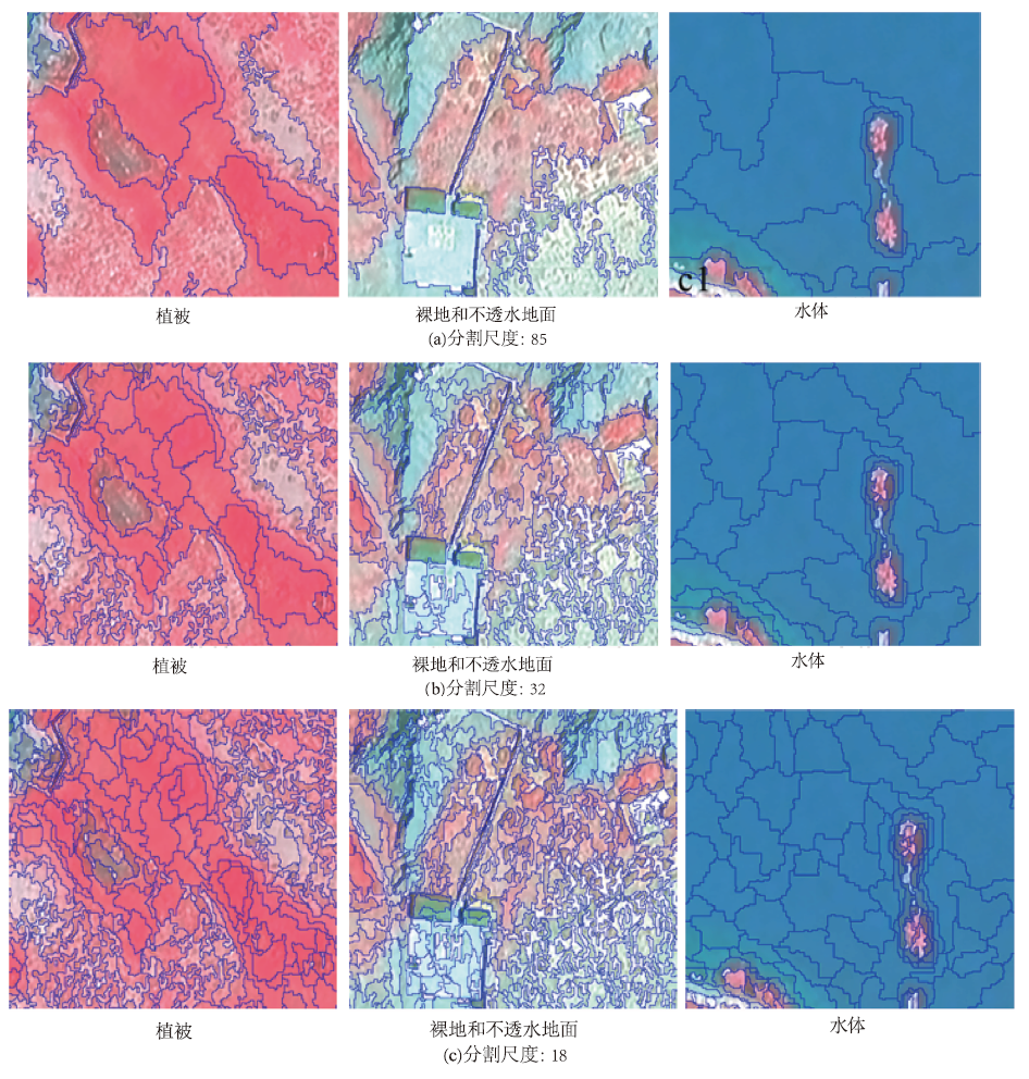
陈春雷, 武刚. 面向对象的遥感影像最优分割尺度评价[J]. 遥感技术与应用, 2011, 26(1):96-102.
|
| [28] |
郭亚鸽, 于信芳, 江东, 等. 面向对象的森林植被图像识别分类方法[J]. 地球信息科学学报, 2012, 14(4):514-522.
|
| [29] |
Benz U C, Hofmann P, Willhauck G, et al. Multi-resolution,object-oriented fuzzy analysis of remote sensing data for GIS-ready information[J]. ISPRS Journal of photogrammetry and remote sensing, 2004, 58(3-4):239-258.
doi: 10.1016/j.isprsjprs.2003.10.002
|
| [30] |
邬亚娟, 刘廷玺, 童新, 等. 基于面向对象的干旱半干旱地区植被分类[J]. 干旱区研究, 2020, 37(4):1026-1034.
|
| [31] |
马浩然, 赵天忠, 曾怡. 面向对象的最优分割尺度下多层次森林植被分类[J]. 东北林业大学学报, 2014, 42(9):52-57.
|
| [32] |
陈丽萍, 孙玉军. 基于不同决策树的面向对象林区遥感影像分类比较[J]. 应用生态学报, 2018, 29(12):3995-4003.
doi: 10.13287/j.1001-9332.201812.015
|
| [33] |
李哲, 张沁雨, 彭道黎. 基于高分二号遥感影像的树种分类方法[J]. 遥感技术与应用, 2019, 34(5):970-982.
|
| [34] |
宗影, 李玉凤, 刘红玉. 基于面向对象随机森林方法的滨海湿地植被分类研究[J]. 南京师范大学学报:工程技术版, 2021, 21(4):47-55.
|
| [35] |
张晨宇, 陈沈良, 李鹏, 等. 现行黄河口保护区典型湿地植被时空动态遥感监测[J]. 海洋学报, 2022, 44(1):125-136.
|
| [36] |
施佩荣, 陈永富, 刘华, 等. 基于改进的面向对象遥感影像分类方法研究:以西藏米林县典型林区为例[J]. 遥感技术与应用, 2017, 32(3):466-474.
|
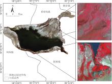
 ), 李强峰1(