欢迎访问林业资源管理

林业资源管理 ›› 2021, Vol. 0 ›› Issue (3): 114-119.doi: 10.13466/j.cnki.lyzygl.2021.03.018

• 科学研究 • 上一篇    下一篇

无人机遥感影像速生桉林分参数自动化提取研究

邱世平1(), 韦明新1, 马依莎2   

  1. 1.广西南宁林业勘测设计院有限公司,南宁 530001
    2.国家林业和草原局林产工业规划设计院,北京 100010
  • 收稿日期:2021-02-03 修回日期:2021-05-18 出版日期:2021-06-28 发布日期:2021-08-04
  • 作者简介:邱世平(1983-),男,广西梧州人,高工,主要从事林业调查规划设计和森林资源监测。Email: 176380636@qq.com

Study on Automatic Extraction of Fast-Growing Eucalyptus Stand Parameters Based on UAV Remote Sensing Images

QIU Shiping1(), WEI Mingxin1, MA Yisha2   

  1. 1. Nanning Institute Forestry Survey and Design of Guangxi Co.Ltd.,Nanning 530001,China
    2. Planning and Design Institute of Forest Products Industry,National Forestry and Grassland Administration,Beijing 100010,China
  • Received:2021-02-03 Revised:2021-05-18 Online:2021-06-28 Published:2021-08-04

摘要:

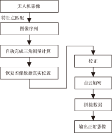
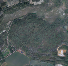
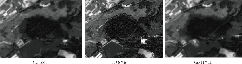
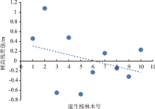
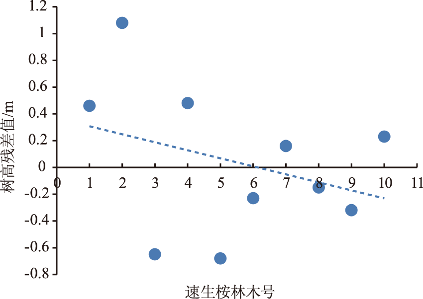
在实景三维建模软件支持下,使用无人机遥感技术快速获取广西扶绥县龙头乡将军屯速生桉林影像,通过Pix4d软件对航摄数据进行自动化内业处理,获取数字正射影像成果(DOM)和数字地表模型(DSM)以及树冠高度模型。基于此树冠高度模型,提取速生桉林的株数、树高、郁闭度等森林参数,并进行精度分析。结果表明:株数精度验证指标(株数探测率、株数准确率、F参数)较优;树高估测值与树高实测值存在较强相关性;郁闭度参数准确率高达92.85%。该林分参数自动化提取方法,能够达到相关实践要求,可以在一定程度上替代人工实测,在人工林中具有广阔应用前景。

关键词: 无人机, 遥感影像, 速生桉林, 森林参数, 自动化提取

Abstract:

With the support of real-world 3D modeling software,the UAV remote sensing technology was used to obtain images of fast-growing eucalyptus areas in Fusui County,Guangxi.The aerial photography data was processed automatically with Pix4d software,so as to obtain the Digital Orthophoto Map l(DOM),Digital Surface Model (DSM) and crown height model.Then the fast-growing eucalyptus forest tree stem,tree height,canopy density and other forest parameters were extracted based on the crown height model,and the precision of the extracted parameters was analyzed.The results showed that the stem precision verification index (stem detection rate,accuracy rate and f parameter) was better,and there was a strong correlation between the estimated value of tree height and the measured value of tree overestimation,and the accuracy of canopy density was 92.85%.The automatic extraction method of fast growing Eucalyptus stand parameters based on UAV remote sensing image could meet the relevant practical requirements,it could replace the manual measurement to a certain extent,and it would have broad application prospect in plantation.

Key words: UAV, remote sensing image, fast growing eucalyptus forest, forest parameters, automatic extraction

中图分类号: