欢迎访问林业资源管理

林业资源管理 ›› 2017, Vol. 0 ›› Issue (3): 120-127.doi: 10.13466/j.cnki.lyzygl.2017.03.023

• 技术应用 • 上一篇    下一篇

北斗卫星导航在林业中的应用模式研究

胡鸿1(), 杨雪清1, 黄静华2, 林志英2, 吴东亮2()   

  1. 1.国家林业局调查规划设计院,北京 100174
    2.北京联合大学,北京 100101
  • 收稿日期:2017-03-16 修回日期:2017-06-12 出版日期:2017-06-28 发布日期:2020-09-24
  • 通讯作者: 吴东亮
  • 作者简介:胡鸿(1983-),男,内蒙古包头人,工程师,主要从事林业信息化和地理信息系统、卫星导航、卫星遥感、卫星通信在林业中的应用工作。Email:huhongbest@163.com
  • 基金资助:
    北斗卫星导航在林业中的示范应用工程项目(发改办高技〔2014〕2563号)

Research on Application Model of Beidou Satellite Navigation in Forestry

HU Hong1(), YANG Xueqing1, HUANG Jinghua2, LIN Zhiying2, WU Dongliang2()   

  1. 1. Academy of Forest Inventory and Planning,State Forestry Administrationg,Beijing 100714,China
    2. Beijing Union University,Beijing 100101,China
  • Received:2017-03-16 Revised:2017-06-12 Online:2017-06-28 Published:2020-09-24
  • Contact: WU Dongliang

摘要:

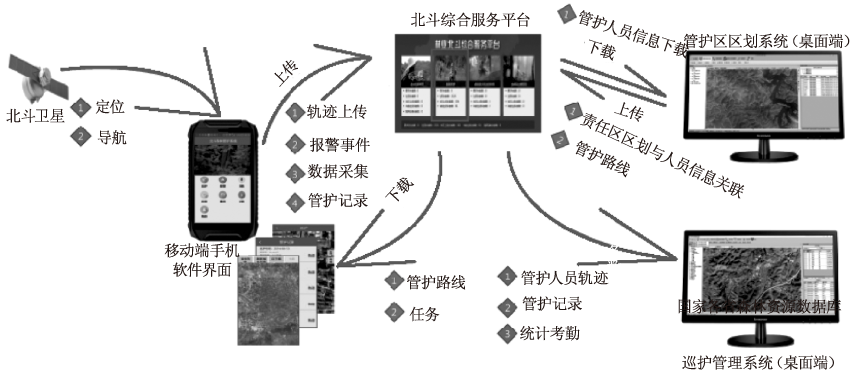
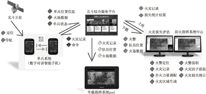
将北斗卫星导航与林业业务关联,使北斗卫星导航与多种应用技术结合,如移动互联网技术、北斗短报文和地图服务等,并在与之相关应用系统中实现。同时,通过对卫星导航的基础据采集,将北斗卫星与GPS的单双模导航的卫星个数、信号强度和PDOP综合位置精度因子等进行统计分析,比较了这两种卫星导航精度的差异,结果表明北斗导航在数据的稳定性上具有优势。

关键词: 北斗卫星导航, 林业, 应用模式

Abstract:

In this paper,discussions are presented on Beidou satellite navigation and forestry business associated with the Beidou satellite navigation and a variety of application technologies,such as mobile Internet technology,Beidou short message and map services,and related applications with the system. At the same time,on the basis of the number of satellite navigation according to the collection,statistical analysis is done on the Beidou satellite and GPS single and dual mode navigation satellite number,signal strength and PDOP integrated position accuracy factor and the differences between the two satellite navigation accuracy compared,The results show that the Beidou navigation has advantages in the data stability.

Key words: Beidou navigation, forestry, application mode

中图分类号: