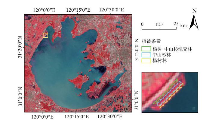
| [1] |
颜昌宙, 金相灿, 赵景柱, 等. 湖滨带的功能及其管理[J]. 生态环境, 2005(2):294-298.
|
| [2] |
王文杰, 张建辉, 李雪. 遥感在生态与环境监测中的主要应用领域[J]. 中国环境监测, 1999(6):48-51.
|
| [3] |
潘蔷, 吴桐, 李明纯, 等. 遥感在植被监测中的应用[J]. 林业科技情报, 2016,48(2):44-46.
|
| [4] |
刘佳, 王利民, 杨福刚, 等. 红边与短波红外谱段的玉米大豆识别能力研究[J]. 中国农学通报, 2018,34(35):120-129.
|
| [5] |
杨超, 邬国锋, 李清泉, 等. 植被遥感分类方法研究进展[J]. 地理与地理信息科学, 2018,34(4):24-32.
|
| [6] |
Clevers J G P W, Gitelson A A. Remote estimation of crop and grass chlorophyll and nitrogen content using red-edge bands on Sentinel-2 and-3[J]. International Journal of Applied Earth Observation and Geoinformation, 2013,23:344-351.
doi: 10.1016/j.jag.2012.10.008
|
| [7] |
浦瑞良, 宫鹏. 高光谱遥感及其应用[M]. 北京: 高等教育出版社, 2003: 254.
|
| [8] |
Schuster C, Forster M, Kleinschmit B. Testing the red edge channel for improving land-use classifications based on high-resolution multi-spectral satellite data[J]. International Journal of Remote Sensing, 2012,33(17/18):5583-5599.
doi: 10.1080/01431161.2012.666812
|
| [9] |
陈兵, 韩焕勇, 王方永, 等. 利用光谱红边参数监测黄萎病棉叶叶绿素和氮素含量[J]. 作物学报, 2013,39(2):319-329.
|
| [10] |
Horler D N H, Dockray M, Barber J. The red edge of plant leaf reflectance[J]. International Journal of Remote Sensing, 1983,4(2):273-288.
doi: 10.1080/01431168308948546
|
| [11] |
Filella I, Penuelas J. The red edge position and shape as indicators of plant chlorophyll content,biomass and hydric status[J]. International journal of remote sensing, 2007,15(7):1459-1470.
doi: 10.1080/01431169408954177
|
| [12] |
郑利娟. 基于高分一/六号卫星影像特征的农作物分类研究[D]. 北京: 中国科学院大学(中国科学院遥感与数字地球研究所), 2017.
|
| [13] |
张卫春, 刘洪斌, 武伟. 基于随机森林和Sentinel-2影像数据的低山丘陵区土地利用分类——以重庆市江津区李市镇为例[J]. 长江流域资源与环境, 2019,28(6):1334-1343.
|
| [14] |
Sibanda M, Mutanga O, Rouget M. Testing the capabilities of the new WorldView-3 space-borne sensor's red-edge spectral band in discriminating and mapping complex grassland management treatments[J]. International Journal of Remote Sensing, 2017,38(1/2):1-22.
|
| [15] |
浦瑞良, 宫鹏. 森林生物化学与CASI高光谱分辨率遥感数据的相关分析[J]. 遥感学报, 1997(2):115-123.
|
| [16] |
方灿莹, 王琳, 徐涵秋. 不同植被红边指数在城市草地健康判别中的对比研究[J]. 地球信息科学学报, 2017,19(10):1382-1392.
doi: 10.3724/SP.J.1047.2017.01382
|
| [17] |
毕恺艺, 牛铮, 黄妮, 等. 基于Sentinel-2A时序数据和面向对象决策树方法的植被识别[J]. 地理与地理信息科学, 2017,33(5):16-20.
|
| [18] |
郭文婷, 张晓丽. 基于Sentinel-2时序多特征的植被分类[J]. 浙江农林大学学报, 2019,36(5):849-856.
|
| [19] |
汪政辉, 辛存林, 孙喆, 等. Sentinel-2数据的小型湖泊水生植被类群自动提取方法——以翠屏湖为例[J]. 遥感信息, 2019,34(5):132-141.
|
| [20] |
朱晓成, 吴永波, 余昱莹, 等. 太湖乔木林河岸植被缓冲带截留氮素效率[J]. 浙江农林大学学报, 2019,36(3):565-572.
|
| [21] |
周子尧, 吴永波, 余昱莹, 等. 河岸杨树人工林缓冲带对径流水中磷素截留效果的研究[J]. 南京林业大学学报:自然科学版, 2019,43(2):100-106.
|
| [22] |
王秋光. 太湖竺山湾植被缓冲带对地表径流的净化效果[D]. 哈尔滨: 东北林业大学, 2014.
|
| [23] |
方红亮, 田庆久. 高光谱遥感在植被监测中的研究综述[J]. 遥感技术与应用, 1998(1):65-72.
|
| [24] |
李晓兵, 王瑛, 李克让. NDVI对降水季节性和年际变化的敏感性[J]. 地理学报, 2000(S1):82-89.
doi: 10.11821/xb2000S1013
|
| [25] |
杨胜天, 刘昌明, 孙睿. 近20年来黄河流域植被覆盖变化分析[J]. 地理学报, 2002(6):679-684.
|
| [26] |
郭铌. 植被指数及其研究进展[J]. 干旱气象, 2003(4):71-75.
|
| [27] |
莫康乐, 陈立欣, 周洁, 等. 永定河沿河沙地杨树人工林蒸腾耗水特征及其环境响应[J]. 生态学报, 2014,34(20):5812-5822.
|
| [28] |
王丹碧, 余华, 凌子然, 等. 落羽杉与墨西哥落羽杉3个杂交后代品系的生长和杂种优势分析[J]. 植物资源与环境学报, 2017,26(1):55-62.
|
 ), 张栋2,3, 徐丹丹1,4, 栾兆擎1,4