| [1] |
孙华, 鞠洪波, 张怀清, 等. 基于Worldview-2影像的林木冠幅提取与树高反演[J]. 中南林业科技大学学报, 2014,34(10):45-50.
|
| [2] |
McRoberts R E, Tomppo E O. Remote sensing support for national forest inventories[J]. Remote sensing of environment, 2007,110(4):412-419.
|
| [3] |
Corona P. Consolidating new paradigms in large-scale monitoring and assessment of forest ecosystems[J]. Environmental research, 2016,144:8-14.
doi: 10.1016/j.envres.2015.10.017
pmid: 26514075
|
| [4] |
吴楠, 李增元, 廖声熙, 等. 国内外林业遥感应用研究概况与展望[J]. 世界林业研究, 2017,30(6):34-40.
|
| [5] |
Goetz S, Dubayah R . Advances in remote sensing technology and implications for measuring and monitoring forest carbon stocks and change[J]. Carbon Management, 2011,2(3):231-244.
|
| [6] |
庄永健, 冯仲科, 李亚藏, 等. 激光雷达技术测树方法原理与应用[J]. 林业资源管理, 2016(6):116-119.
|
| [7] |
庞勇, 李增元, 陈尔学, 等. 激光雷达技术及其在林业上的应用[J]. 林业科学, 2005(3):129-136.
|
| [8] |
谢巧雅, 余坤勇, 邓洋波, 等. 杉木人工林冠层高度无人机遥感估测[J]. 浙江农林大学学报, 2019,36(2):335-342.
|
| [9] |
刘浩, 张峥男, 曹林. 机载激光雷达森林垂直结构剖面参数的沿海平原人工林林分特征反演[J]. 遥感学报, 2018,22(5):872-888.
|
| [10] |
李欢, 李明泽, 范文义, 等. 基于机载激光雷达的林隙结构参数提取[J]. 林业科学, 2018,54(10):98-107.
|
| [11] |
聂胜. 基于激光雷达数据的森林冠层参数反演方法研究[D]. 北京:中国科学院大学(中国科学院遥感与数字地球研究所), 2017.
|
| [12] |
Ma Qin, Su Yanjun, Guo Qinghua. Comparison of canopy cover estimations from airborne LiDAR,aerial imagery,and satellite imagery[J]. IEEE Journal of Selected Topics in Applied Earth Observations and Remote Sensing, 2017,10(9):4225-4236.
|
| [13] |
骆钰波, 黄洪宇, 唐丽玉, 等. 基于地面激光雷达点云数据的森林树高、胸径自动提取与三维重建[J]. 遥感技术与应用, 2019,34(2):243-252.
|
| [14] |
李桂林, 王红, 宋音, 等. 黄河三角洲孤岛刺槐林地上生物量的估算—基于无人机机载激光雷达[J]. 中国农学通报, 2018,34(26):52-57.
|
| [15] |
Naesset E. Determination of mean tree height of forest stands using airborne laser scanner data[J]. ISPRS Journal of Photogrammetry and Remote Sensing, 1997,52(2):49-56.
|
| [16] |
李平昊, 申鑫, 代劲松, 等. 机载激光雷达人工林单木分割方法比较和精度分析[J]. 林业科学, 2018,54(12):127-136.
|
| [17] |
耿林, 李明泽, 范文义, 等. 基于机载LiDAR的单木结构参数及林分有效冠的提取[J]. 林业科学, 2018,54(7):62-72.
|
| [18] |
Vastaranta M, Wulder M A, White J C, et al. Airborne laser scanning and digital stereo imagery measures of forest structure:comparative results and implications to forest mapping and inventory update[J]. Canadian Journal of Remote Sensing, 2013,39(5):382-395.
|
| [19] |
陈宗铸, 杨琦, 雷金睿, 等. 基于激光雷达数据的热带森林冠高模型生成及平均树高估计[J]. 中南林业科技大学学报, 2018,38(7):1-7.
|
| [20] |
尤号田, 邢艳秋, 王铮, 等. 点云密度对激光雷达估计森林样方平均树高的影响[J]. 东北林业大学学报, 2014,42(5):143-148.
|
| [21] |
Zhang Wuming, Qi Jianbo, Wan Peng, et al. An easy-to-use airborne LiDAR data filtering method based on cloth simulation[J]. Remote Sensing, 2016,8(6):501-522.
|
| [22] |
段祝庚, 曾源, 赵旦, 等. 机载激光雷达森林冠层高度模型凹坑去除方法[J]. 农业工程学报, 2014,30(21):209-217.
|
| [23] |
尤号田. 基于机载LiDAR数据森林关键结构参数估测研究[D]. 哈尔滨:东北林业大学, 2017.
|
| [24] |
Popescu S C, Wynne R H, Nelson R F. Estimating plot-level tree heights with lidar:local filtering with a canopy-height based variable window size[J]. Computers and Electronics in Agriculture, 2002,37(1-3):71-95.
|
| [25] |
霍达. 基于机载LiDAR反演森林参数的研究——以内蒙古依根地区为例[D]. 哈尔滨:东北林业大学, 2015.
|
| [26] |
蒋馥根, 孙华, 林辉, 等. 旺业甸林场人工林生物量遥感反演研究[J]. 中南林业科技大学学报, 2019,39(10):88-94.
|
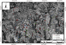
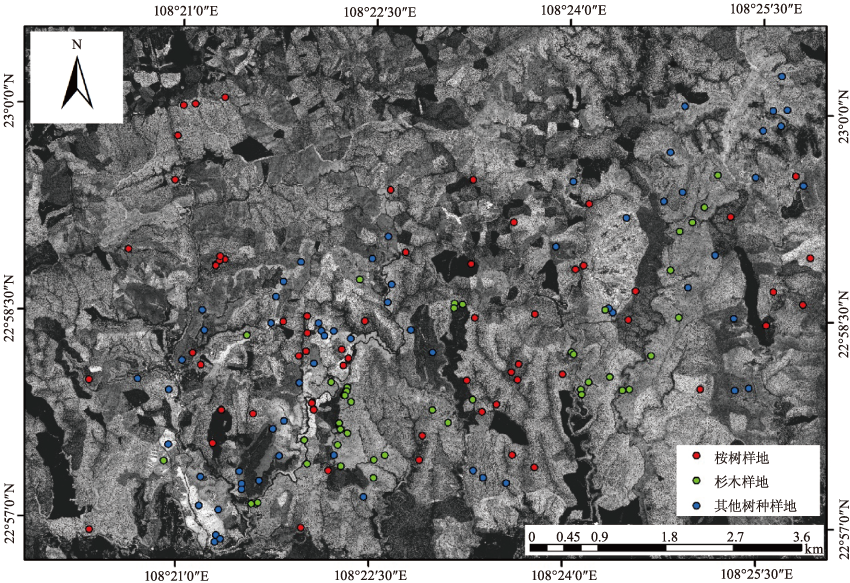
 ), 孙华1,2,3, 林辉1,2,3(