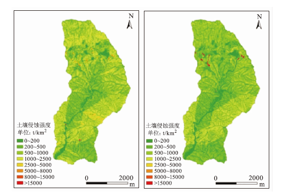
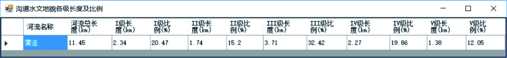
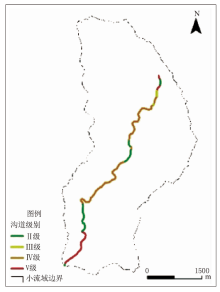
| [1] |
王礼先. 小流域综合治理的概念与原则[J]. 中国水土保持, 2006(2):16-17.
|
| [2] |
张洪江. 我国小流域综合治理面临的问题与对策[J]. 中国水土保持科学, 2016,14(1):131-137.
|
| [3] |
王一鸣, 高鹏, 穆兴民, 等. 南方红壤丘陵区小流域水土保持综合效益评价——以江西阳坑小流域为例[J]. 水土保持研究, 2017,24(5):6-13.
|
| [4] |
谢磊, 武晓峰, 段淑怀. 北京市山区小流域生态清洁程度评价指标体系研究[J]. 中国水土保持, 2012(10):1-2.
|
| [5] |
蒲朝勇, 高媛. 生态清洁小流域建设现状与展望[J]. 中国水土保持, 2015(6):7-10.
|
| [6] |
尚书. 小流域土壤侵蚀评价系统的设计与实现[D]. 北京:北京林业大学, 2015.
|
| [7] |
祝赢, 章文波, 刘素红, 等. 第一次全国水利普查侵蚀模数的批量计算方法——基于CSLE和GIS的土壤水蚀模数计算器设计与应用[J]. 水土保持通报, 2012,32(5):291-295.
|
| [8] |
陈金星, 岳德鹏, 王计平, 等. 土壤侵蚀GIS计算系统的研建与应用[J]. 西北林学院学报, 2016,31(1):206-213.
|
| [9] |
国家林业局. LY/T 1721-2008(2010),森林生态系统服务功能评估规范[S]. 北京: 中国标准出版社,2010年.
|
| [10] |
张建军, 纳磊, 张波. HEC-HMS分布式水文模型在黄土高原小流域的可应用性[J]. 北京林业大学学报, 2009,31(3):52-57.
|
| [11] |
Rabi Gyawali, Watkins D W. Continuous hydrologic modeling of snow-affected watersheds in the Great Lakes Basin using HEC-HMS[J]. Journal of Hydrologic Engineering-ASCE, 2013,18(1):29-39.
|
| [12] |
Hydrologic Engineering Center(HEC),Institute for Water Resources,(2015).Hydrologic Modeling System HEC-HMS User’s Manual[M]. Version 4.1,CPT 74A,US Army Corps of Engineering,Davis,CA,USA.
|
| [13] |
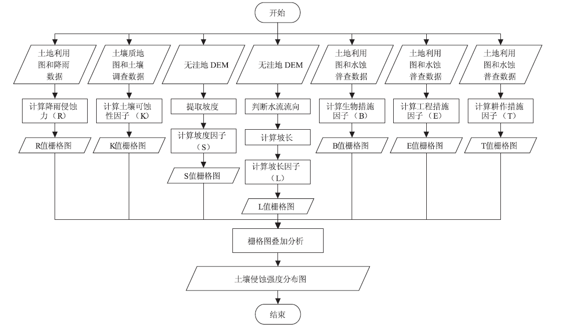
水利部水土保持司. SL190-2007,土壤侵蚀分类分级标准[S]. 北京:中国水利水电, 2007.
|
| [14] |
国务院第一次全国水利普查领导小组办公室. 水土保持情况普查[M]. 北京: 中国水利水电出版社, 2010.
|
| [15] |
Wischmeier W.H, Smith D.D. Predicting Rainfall Erosion Losses—a Guide to Conservation Planning[M]. United States Dept.of Agriculture.Agriculture Handbook, 1978: 537.
|
| [16] |
符素华, 刘宝元, 周贵云, 等. 坡长坡度因子计算工具[J]. 中国水土保持科学, 2015,13(5):105-110.
|
| [17] |
Mccool D K, Brown L C, Foster G R, et al. Revised slope steepness factor for the universal soil loss equation[J]. Transactions of the ASAE-American Society of Agricultural Engineers(USA), 1987,30(5):1387-1396.
|
| [18] |
Liu B Y, Nearing M A, Shi P J, et al. Slope length effects on soil loss for steep slopes.[J]. Soil Science Society of America Journal, 1994,64(5):1759-1763.
|
| [19] |
刘淼, 胡远满, 徐崇刚. 基于GIS、RS和RUSLE的林区土壤侵蚀定量研究——以大兴安岭呼中地区为例[J]. 水土保持研究, 2004,11(3):21-24.
|
| [20] |
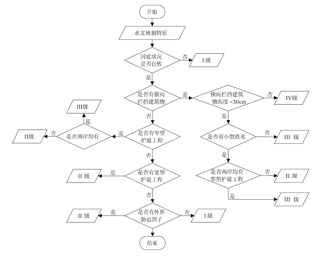
北京市水务局. DB11/T 1173-2015,山区河流水文地貌评价导则[S]. 北京: 中国标准出版社, 2015.
|
| [21] |
陈维川. 北京蒲洼自然保护区植物多样性及其保护研究[D]. 北京:北京林业大学, 2005.
|
 ), 赵天忠1(