欢迎访问林业资源管理

林业资源管理 ›› 2017, Vol. 0 ›› Issue (5): 108-113.doi: 10.13466/j.cnki.lyzygl.2017.05.018

• 科学研究 • 上一篇    下一篇

国家级城市湿地公园景观格局分析——以成都市白鹭湾生态湿地公园为例

高丽楠()   

  1. 成都大学 旅游与经济管理学院,成都 610106
  • 收稿日期:2017-07-05 修回日期:2017-09-26 出版日期:2017-10-28 发布日期:2020-09-24
  • 作者简介:高丽楠(1983-),女,内蒙古呼伦贝尔人,讲师,博士,主要从事景观生态学的研究。Email: gaolinan20081212@163.com
  • 基金资助:
    四川景观与游憩研究中心项目“成都市湿地公园景观格局分析”(JGYQ2015009)

Analysis of Landscape Patterns of National Wetland Parks—A case study of Egret Wetland Park in Chengdu

GAO Linan()   

  1. College of Tourism and Economic Management,Chengdu University,Chengdu 610106,China
  • Received:2017-07-05 Revised:2017-09-26 Online:2017-10-28 Published:2020-09-24

摘要:

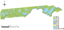
根据收集的白鹭湾生态湿地公园的相关图片资料,运用景观生态学及其高德图片和ArcGIS软件,结合实地调查,采用景观多样性指数和斑块特征指数等指标,对其景观格局进行了分析。研究结果表明:白鹭湾生态湿地公园总面积为200.04hm2,草地和湖泊是湿地公园的主要景观类型,其面积为123.52hm2和26.31hm2,斑块所占景观面积比例分别为61.75%和13.15%;斑块数量(NP)和斑块密度(PD)所反映的湿地景观类型破碎化程度基本一致,其中道路(NP=85个、PD=42.49个/100hm2)和草地(NP=48个、PD=24.00个/100hm2)破碎化程度较高;湿地公园的平均斑块形状指数(MSI)和平均斑块分维数(MPFD)的结果显示,河流(MPFD=1.43,MSI=12.21)的斑块形状较为复杂,灌丛(MPFD=1.07,MSI=1.50)的斑块形状最规则;湿地香农多样性指数(SHDI)为1.31,香农均匀度指数(SHEI)值为0.63,说明研究区域景观水平多样性相对较高,但斑块空间分布不均匀,优势斑块较明显。

关键词: 景观生态学, 景观格局分析, 白鹭湾生态湿地公园

Abstract:

Based on some data of Egret Wetland Park and principles of landscape ecology,ArcGIS software and Amap photo pictures had been used,meanwhile the spots had been investigated. The characteristic index of patches,the landscape diversity index had been selected to analyze the spatial pattern of Egret Wetland Park area. The total area of Egret Wetland Park area was 200.04 hm2,the grassland and lake were the main landscapes in Egret Wetland Park,which accounted for 123.52 hm2 and 26.31 hm2,PLAND were 61.75% and 13.15%. From the results of patch density(PD)and number of patches(NP),the degrees of fragmentation of different sights were similar,it showed that the degree of fragmentation of road(NP=85 n,PD=42.49 n/100hm2)and grassland(NP=48 n,PD=24.00 n/100hm2)were higher. In addition,the calculation results of mean shape index(MSI)and mean patch fractal dimension(MPFD)indicated that the river(MPFD=1.43,MSI=12.21)was the most complicated in patch shape,while shrub(MPFD=1.07,MSI=1.50)was simplest. The Shannon’s diversity index was 1.31,the Shannon’s evenness index was 0.63,which indicated that the landscape diversity was high,the dominant patch was obvious,the distribution of patches was not uniform.

Key words: landscape ecology, landscape pattern analysis, Egret Wetland Park

中图分类号: