| [1] |
欧阳志云, 王效科, 苗鸿. 中国生态环境敏感性及其区域差异规律研究[J]. 生态学报, 2000(1):10-13.
|
| [2] |
庄立君. 自然资源利用和生态环境保护平衡问题的研究讨论[J]. 现代农业研究, 2024, 30(3):100-102.
|
| [3] |
刘木生, 林联盛, 郭秋忠. 基于GIS的生态功能分区技术方法刍议[J]. 江西农业学报, 2008(10):111-113.
|
| [4] |
WRIGHT R G, MURRAY M P, MERRILL T. Ecoregions as a level of ecological analysis[J]. Biological Conservation, 1998, 86(2):207-213.
|
| [5] |
孟彩红, 梁冬梅, 孙大光, 等. 基于GIS的区域生态功能红线划分[J]. 江苏农业科学, 2019, 47(6):263-267.
|
| [6] |
资源与人居环境. 中国首部生态保护红线蓝皮书正式发布[J]. 资源与人居环境, 2023(8):6-7.
|
| [7] |
许心倩. 泰安市生态功能区划研究[D]. 北京: 北京林业大学, 2007.
|
| [8] |
刘胤汉, 管海晏, 岳大鹏, 等. 陕西省生态环境综合分区研究[J]. 陕西师范大学学报(自然科学版), 2002(2):109-114.
|
| [9] |
赵万奎, 张晓庆, 陈智平, 等. 基于GIS的金昌市生态功能区划分及发展对策[J]. 草业科学, 2019, 36(11):2989-2996.
|
| [10] |
杨伟州, 邱硕, 付喜厅, 等. 河北省生态功能区划研究[J]. 水土保持研究, 2016, 23(4):269-276.
|
| [11] |
赵斌. 流域是生态学研究的最佳自然分割单元[J]. 科技导报, 2014, 32(1):12.
|
| [12] |
高海燕, 王鑫, 杨振奇, 等. 黄河中游窟野河流域土壤侵蚀与生态修复研究进展[J]. 内蒙古大学学报(自然科学版), 2024, 55(3):329-336.
|
| [13] |
毕早莹, 李艳忠, 林依雪, 等. 基于Budyko理论定量分析窟野河流域植被变化对径流的影响[J]. 北京林业大学学报, 2020, 42(8):61-71.
|
| [14] |
圆圆, 盛艳, 刘林甫, 等. 窟野河流域生境质量时空演变特征及其影响机制研究[J]. 林草资源研究, 2023(6):67-74.
|
| [15] |
刘永刚. 窟野河流域煤炭开采对水资源影响分区研究[J]. 地下水, 2022, 44(4):72-75.
|
| [16] |
张东, 曹莹, 赵志琦, 等. 煤矿开采活动对黄河中游窟野河流域溶解性硫酸盐的影响[J]. 地球科学与环境学报, 2023, 45(2):414-426.
|
| [17] |
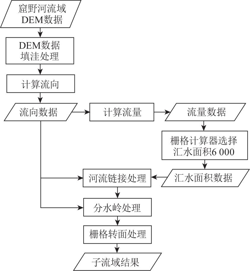
郝芳华, 张雪松, 程红光, 等. 分布式水文模型亚流域合理划分水平刍议[J]. 水土保持学报, 2003(4):75-78.
|
| [18] |
宋友城, 田毅, 安拴霞. 大清河流域生态功能区划研究[J]. 生态科学, 2021, 40(6):197-206.
|
| [19] |
孙然好, 汲玉河, 尚林源, 等. 海河流域水生态功能一级二级分区[J]. 环境科学, 2013, 34(2):509-516.
|
| [20] |
方源. 北京市水生态功能区划及分级管控策略研究[D]. 武汉: 湖北大学, 2022.
|
| [21] |
许东旺. 基于GIS空间分析的朝阳市龙源湖城市湿地公园生态功能区划研究[D]. 沈阳: 沈阳农业大学, 2023.
|
| [22] |
国家环境保护总局. 生态功能区暂行规程[S]. 北京: 国家环境保护总局, 2002.
|
| [23] |
许月卿, 赵菲菲, 孙丕苓. 基于GIS的张家口市土地生态功能分区与调控研究[J]. 资源开发与市场, 2015, 31(12):1480-1483.
|
| [24] |
陈万基, 赵阳, 崔东, 等. GIS支持下绿洲生态敏感性研究:以伊犁河谷为例[J]. 测绘通报, 2023(5):107-114.
doi: 10.13474/j.cnki.11-2246.2023.0145
|
| [25] |
孙苑苑, 王琳, 王晋. 黄河三角洲自然保护区生态敏感性评价[J]. 中国海洋大学学报(自然科学版), 2017, 47(11):96-102.
|
| [26] |
赵迅, 徐艳芳, 王浩天, 等. 基于GIS的黔西市生态敏感性评价与分析[J]. 安徽农业科学, 2023, 51(19):64-68.
|
| [27] |
朱启明, 刘俊娥, 周正朝. 黄土高原土壤可蚀性因子空间分布特征及影响因素[J]. 水土保持学报, 2023, 37(6):50-56.
|
| [28] |
岑奕, 丁文峰, 张平仓. 华中地区土壤可蚀性因子研究[J]. 长江科学院院报, 2011, 28(10):65-68.
|
| [29] |
王曙平. 生态环境治理视角下的城市更新与持续变革[J]. 施工企业管理, 2024(7):49-51.
|
| [30] |
杨丹荔, 李益彬, 李雪梅, 等. 中国七大流域水资源供需平衡及其可持续性[J]. 水土保持通报, 2024, 44(6):269-277.
|
| [31] |
唐光清. 废弃矿山植被恢复的策略与效果评价[J]. 世界有色金属, 2024(15):124-126.
|
| [32] |
阿古达木, 其力莫格. “碳达峰、碳中和”背景下内蒙古畜牧业减碳增效路径分析[J]. 当代畜禽养殖业, 2024, 44(3):47-49.
|
| [33] |
恩和, 阿拉坦格日乐, 雅日桂. 生态保护视角下内蒙古草原畜牧业分区经营研究[J]. 大连民族大学学报, 2023, 25(4):330-336.
|
| [34] |
胡继峰, 齐建飞, 鲁艳春. 特大地震、泥石流抢险救援技术研究与应用[J]. 人民黄河, 2024, 46(S2):130-131.
|
| [35] |
陈宁生, 刘美, 刘丽红. 关于山洪与泥石流灾害及其流域性质判别的讨论[J]. 灾害学, 2018, 33(1):39-43.
|
 ), QIN Fucang1,2,3(