

Forest and Grassland Resources Research ›› 2026›› Issue (2): 102-114.doi: 10.13466/j.cnki.lczyyj.2026.02.010
• Technical Application • Previous Articles Next Articles
WANG Mingxing1( ), SHU Qingtai1(), XIA Cuifen1, WU Zaikun1, ZHOU Sai1, DUAN Dandan2, LI Shengjiao3
Received:2024-10-23
Revised:2025-09-30
Online:2026-04-28
Published:2026-09-30
CLC Number:
WANG Mingxing, SHU Qingtai, XIA Cuifen, WU Zaikun, ZHOU Sai, DUAN Dandan, LI Shengjiao. Inversion of aboveground biomass of Dendrocalamus giganteus by using spaceborne LiDAR and optical remote sensing data[J]. Forest and Grassland Resources Research, 2026, (2): 102-114.
Add to citation manager EndNote|Ris|BibTeX
URL: https://www.lyzygl.com.cn/EN/10.13466/j.cnki.lczyyj.2026.02.010
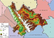
Fig.1
Summary of the study area
Tab.1
Standard Dendrocalamus giganteus index measurement statistical table
| 名称 | 胸径/cm | 地上生物量/(t/hm2) |
|---|---|---|
| 最大值 | 12.50 | 132.13 |
| 最小值 | 5.60 | 23.46 |
| 平均值 | 9.04 | 66.91 |
| 标准差 | 1.52 | 27.86 |
Tab.2
Spotlight filtering indicators and modeling indicators of GEDI L2B data products
| 参数 | 描述 | 参数 | 描述 |
|---|---|---|---|
| cover | 总冠层覆盖率 | fhd_normal | 叶高多样性指数 |
| pai | 植被面积指数 | solar_elevation | 太阳高度角 |
| degrade_flag | 卫星地理位置信息降级状态标识 | modis_treecover | MODIS数据树木覆盖率 |
| pgap_theta_aN | 垂直冠层方向植被间隙 | modis_nonvegetated | MODIS数据的无植被标准差百分比 |
| digital_elevation_mode | WGS84椭球之上的数字高程模型高度 | leaf_on_doy | 展叶期的儒略日 |
| leaf_off_doy | 无叶期的儒略日 | rv_aN | 波形中植被分量积分 |
| rg_aN | 波形中地面分量的积分 | sensitivity | 可穿透林冠中最大树木的波形 |
| rh100 | 接收波形信号开始时的离地高度 | quality_flag | 简化选择最有用数据的标志 |
| landsat_treecover | Landsat数据树木覆盖度 | rx_energy_aN | 去除平均噪声后接收到的波形总能量 |
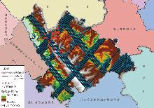
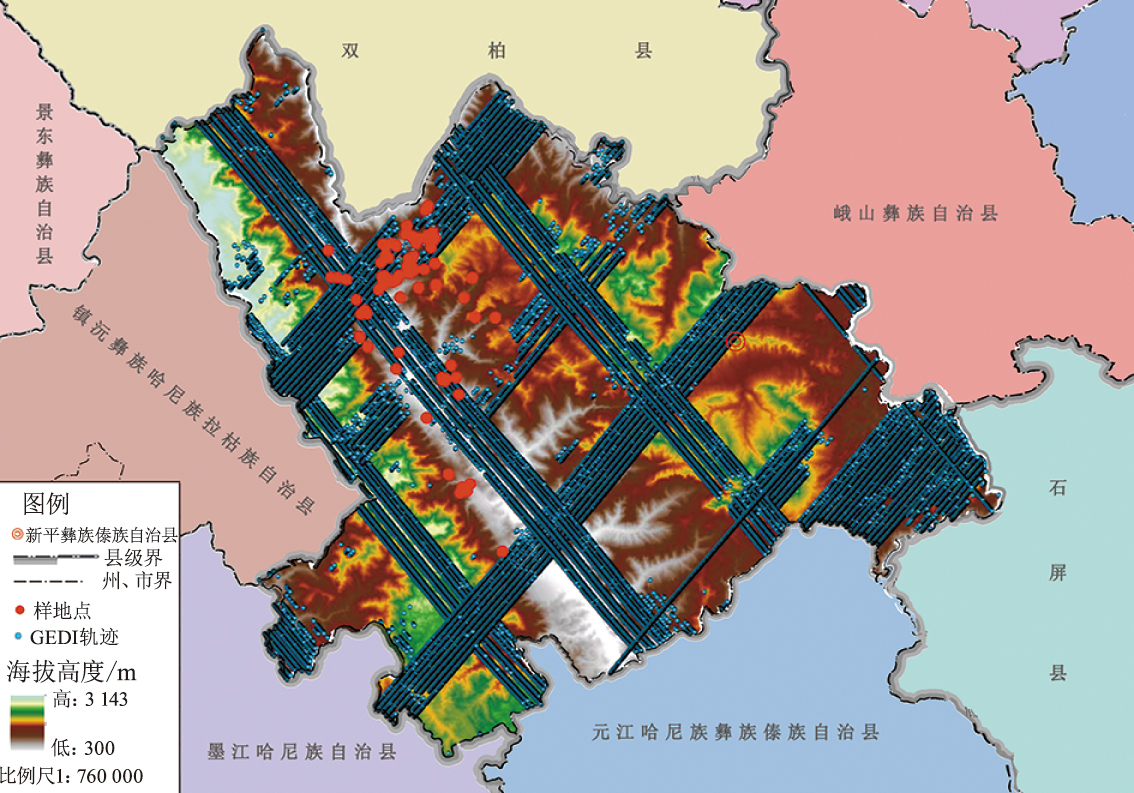
Fig.2
GEDI track map of Xinping County
Tab.3
Vegetation index and calculation formula of Sentinel-2 Level-2A reflectance images
| 植被指数名称 | 计算公式 | 变量释义 |
|---|---|---|
| 归一化植被指数 (Normalized Difference Vegetation Index) | INDV=(ρNIR-ρRed)/(ρNIR+ρRed) | INDV为归一化植被指数;IRGV为红绿植被指数;IGNDV为绿色归一化植被指数;IDV为差值植被指数;IEV为增强植被指数;IARV为大气抗阻植被指数;IVAR为大气阻力指数;IIPV为红外百分比植被指数;IGC为绿色叶绿素指数;IRV为比值植被指数;ρ为某个特定波段的反射率值;NIR为近红外波段;Red为红色波段;Green为绿色波段;Blue为蓝色波段。 |
| 红绿植被指数 (Red-Green Vegetation Index) | IRGV=(ρRed-ρGreen)/(ρRed+ρGreen) | |
| 绿色归一化植被指数 (Green Normalized Difference Vegetation Index) | IGNDV=(ρNIR-ρGreen)/(ρNIR+ρGreen) | |
| 差值植被指数 (Difference Vegetation Index) | IDV=ρNIR-ρRed | |
| 增强植被指数 (Enhanced Vegetation Index) | IEV=[2.5×(ρNIR-ρRed)]/(ρNIR+6×ρRed-7.5×ρBlue+1) | |
| 大气阻抗植被指数 (Atmospherically Resistant Vegetation Index) | IARV=[ρNIR-(2×ρRed-ρBlue)]/[ρNIR+(2×ρRed-ρBlue)] | |
| 可见光大气阻抗指数 (Visible Atmospherically Resistant Index) | IVAR=(ρGreen-ρRed)/(ρGreen+ρRed-ρBlue) | |
| 红外百分比植被指数 (Infrared Vegetation Index) | IIPV=ρNIR/ρNIR+ρRed | |
| 绿色叶绿素指数 (Green Chlorophyll Index) | IGC=ρNIR/ρGreen-1 | |
| 比值植被指数 (Ratio Vegetation Index) | IRV=ρNIR/ρRed |
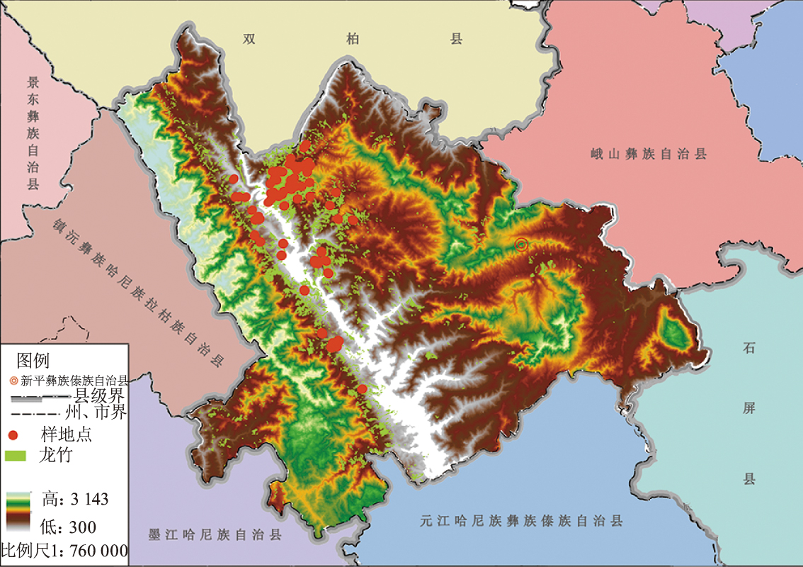
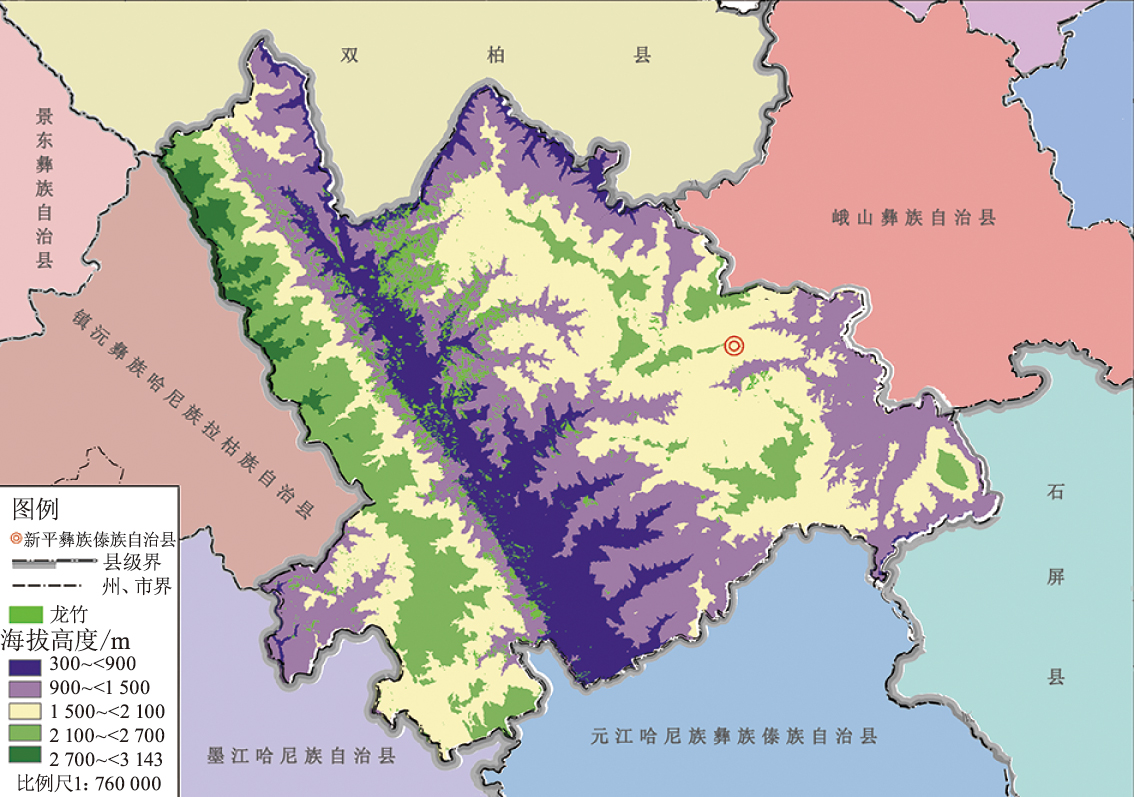
Fig.3
Elevation and distribution map of Dendrocalamus giganteus in Xinping County
Tab.4
Result of variance function of each parameter after screening
| 参数名称 | 模型 | 块金值 (C0) | 偏基台值 (C) | 基台值 (C0+C) | 结构比 [C/(C0+C)] | 决定系数 (R2) | 残差平方和 (RSS) | 变程 (A) |
|---|---|---|---|---|---|---|---|---|
| modis_treecover | 球状模型 | 237.00 | 454.10 | 691.10 | 65.71% | 0.85 | 24 822.00 | 15 300.00 |
| landsat_treecover | 指数模型 | 194.00 | 1 161.00 | 1 355.00 | 85.68% | 0.81 | 32 700.00 | 6 600.00 |
| digital_elevation_model | 球状模型 | 34 000.00 | 317.00 | 351 900.00 | 90.34% | 0.81 | 0.90 | 15 000.00 |
| modis_nonvegetated | 指数模型 | 37.90 | 37.91 | 75.81 | 50.01% | 0.77 | 214.00 | 22 500.00 |
Tab.5
The result of cross-validation of Kriging interpolation
| 参数名称 | 模型 | 平均误差 (ME) | 均方根误差 (RMSE) | 标准均方误差 (MSE) | 标准均方根误差 (SRMSE) | 平均标准误差 (ASE) | 决定系数 (R2) |
|---|---|---|---|---|---|---|---|
| modis_treecover | 球状模型 | 0.00 | 6.24 | 0.00 | 0.67 | 7.03 | 0.95 |
| landsat_treecover | 指数模型 | 0.07 | 17.65 | 0.01 | 0.77 | 18.10 | 0.73 |
| digital_elevation_mode | 球状模型 | 0.32 | 40.65 | 0.01 | 0.44 | 42.32 | 0.91 |
| modis_nonvegetated | 指数模型 | 0.01 | 2.56 | 0.00 | 0.69 | 3.62 | 0.88 |

Fig.4
Pearson correlation heat map
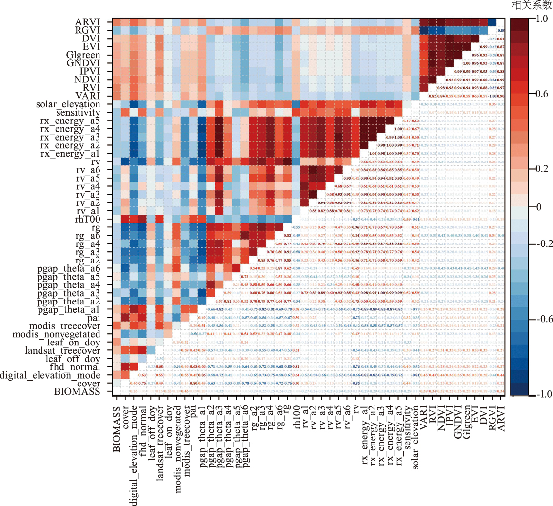
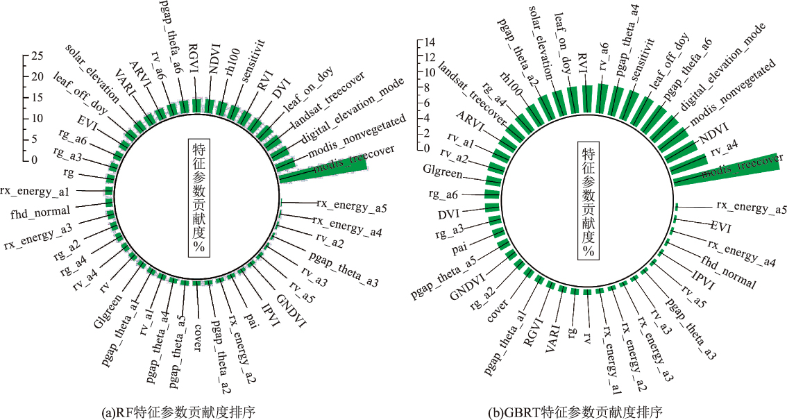
Fig.5
Ranking of contribution degrees of RF and GBRT characteristic parameters
Tab.6
The combined results of each model and parameter
| 模型 | 数据源 | 决定 系数 (R2) | 均方根误差 (RMSE)/ (t/hm2) | |
|---|---|---|---|---|
| GBRT | 单一GEDI数据 | 0.92 | 7.77 | |
| 单一 Sentinel-2数据植被指数 | 0.84 | 11.00 | ||
| GEDI数据及 Sentinel-2数据植被指数 | 0.93 | 7.47 | ||
| RF | 单一GEDI数据 | 0.87 | 9.95 | |
| 单一 Sentinel-2数据植被指数 | 0.74 | 14.17 | ||
| GEDI数据及 Sentinel-2数据植被指数 | 0.88 | 9.60 | ||
Fig.6
The model fits the scatter plot
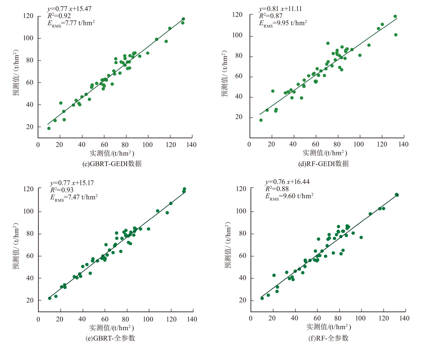
Fig.7
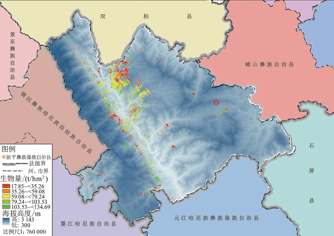
Biomass distribution map of Dendrocalamus giganteus in Xinping county
| [1] | Food and Agriculture Organization of the United Nations. Global forest resources assessment 2010 main report[R]. Rome:FAO, 2010. |
| [2] | 冯仲科, 罗旭, 石丽萍. 森林生物量研究的若干问题及完善途径[J]. 世界林业研究, 2005, 18(3):25-28. |
| [3] | Ebermeyer E. Die gesamte lehre der waldstreu mit rücksicht auf die chemische static des waldbaues[M]. Berlin: J springer, 1876. |
| [4] | 郝晴, 王昌. 森林地上生物量遥感估算研究综述[J]. 植物生态学报, 2023, 47(10):1356-1374. |
| [5] |
Fedorov N, Bikbaev I, Shirokikh P, et al. Estimation of carbon stocks of birch forests on abandoned arable lands in the Cis-Ural using unmanned aerial vehicle-mounted LiDAR camera[J]. Forests, 2023, 14(12):2392-2406.
doi: 10.3390/f14122392 |
| [6] | 陈舒怀, 谭宏超. 龙竹的生物学和生态学特性[J]. 云南林业科技, 1997(4):36-39. |
| [7] | 王玲. 竹类植物的工业利用途径综述[J]. 安徽农业科学, 2011, 39(17):10294-10296. |
| [8] | 田芸, 安胜足, 孙照斌. 龙竹竹材的吸水膨胀特性[J]. 福建林业科技, 2007(2):148-150. |
| [9] | 李云海, 陈丽华, 吕诗涵, 等. 云南龙竹试管无性系的建立及快繁研究[J]. 西部林业科学, 2020, 49(1):16-19. |
| [10] |
倪惠菁, 储昊煜, 苏文会, 等. 经营强度对毛竹林土壤团聚体稳定性和碳氮磷分布的影响[J]. 应用生态学报, 2023, 34(4):928-936.
doi: 10.13287/j.1001-9332.202304.002 |
| [11] | Du Huaqiang, Cui Ruirui, Zhou Guomo, et al. The responses of Moso bamboo(Phyllostachys heterocycla var.pubescens)forest aboveground biomass to Landsat TM spectral reflectance and NDVl[J]. Aeta Eeologica Sinica, 2010, 30(5):257-263. |
| [12] |
温雨笑, 吕杰, 马庆勋, 等. 高光谱和LiDAR联合反演森林生物量研究[J]. 测绘通报, 2022(7):38-42.
doi: 10.13474/j.cnki.11-2246.2022.0200 |
| [13] | 杨可乐, 谭艳, 郭孝玉, 等. 集成多源遥感与极限梯度提升的竹林地上生物量估测[J]. 森林与环境学报, 2024, 44(4):431-440. |
| [14] | 王柯人, 罗文秀, 舒清态, 等. 龙竹人工林的含水率分析及地上生物量回归模型构建[J]. 西南林业大学学报, 2021, 41(6):168-174. |
| [15] |
王路君, 蔡春菊, 唐晓鹿, 等. 硬头黄竹地上生物量分配特征及模型构建[J]. 南京林业大学学报(自然科学版), 2021, 45(1):189-196.
doi: 10.12302/j.issn.1000-2006.202005008 |
| [16] | 张宇, 岳祥华, 漆良华, 等. 利用异速生长关系和地统计方法估算武夷山南麓毛竹林生物量[J]. 生态学杂志, 2016, 35(7):1957-1962. |
| [17] |
Zhang Lingjun, Zhao Yinyin, Chen Chao, et al. UAV-LiDAR integration with Sentinel-2 enhances precision in AGB estimation forbamboo forests[J]. Remote Sensing, 2024, 16(4):705-727.
doi: 10.3390/rs16040705 |
| [18] |
Hemando A, Puerto L, Mola-yudego B, et al. Estimation of forest biomass components using air bome LiDAR and multispectral sensors[J]. iForest-Biogeosciences and Forestry, 2019, 12(2):207-213.
doi: 10.3832/ifor2735-012 |
| [19] | 潘钰涵, 段兴武, 赵文娟. 新平县干热河谷地区农业规模化对农户生计多样化的影响研究[J]. 云南地理环境研究, 2021, 33(5):41-48. |
| [20] | 付小勇, 孙茂盛, 杨宇明, 等. 遥感技术在德宏州大型丛生竹资源监测中的应用研究[J]. 西部林业科学, 2012, 41(4):88-92. |
| [21] | 谢栋平, 李国元, 赵严铭, 等. 美国GEDI天基激光测高系统及其应用[J]. 国际太空, 2018(12):6. |
| [22] | Liang M, Duncansun L, Silva J A, et al. Quantifying aboveground biomass dynamics from charcoal degradation in Mozambique using GEDI Lidar and Landsat[J]. Remote Sensing of Environment:An Interdisciplinary Journal, 2023, 284:113367. |
| [23] |
Xu Li, Lai Hongyan, Yu Jinge, et al. Carbon storage estimation of quercus aquifolioides based on GEDI spaceborne LiDAR data and Landsat 9 images in Shangri-La[J]. Sustainability, 2023, 15(15):11525.
doi: 10.3390/su151511525 |
| [24] | Languille F, Gaudel A, Dechoz C, et al. Sentinel-2A image quality commissioning phase final results:geometric calibration and performances[J]. Sensors,Systems,and Next-Generation Satellites XX, 2016, 10000:64-84. |
| [25] |
Yu Xiaohui, Ge Hongli, Lu Dengsheng, et al. Comparative study on variable selection approaches in establishment of remote sensing model for forest biomass estimation[J]. Remote Sensing, 2019, 11(12):500.
doi: 10.3390/rs11050500 |
| [26] | 刘晓梅, 布仁仓, 邓华卫, 等. 基于地统计学丰林自然保护区森林生物量估测及空间格局分析[J]. 生态学报, 2011, 31(16):4783-4790. |
| [27] |
Xu Li, Shu Qingtai, Fu Huyan, et al. Estimation of quercus biomass in Shangri-La based on GEDI spaceborne LiDAR data[J]. Forests, 2023, 14(5):876.
doi: 10.3390/f14050876 |
| [28] | 刘爱利, 王培法, 丁园圆. 地统计学概论[M]. 北京: 科学出版社, 2012. |
| [29] |
Breiman L. Random forests[J]. Machine Learning. 2001, 45:5-32.
doi: 10.1023/A:1010933404324 |
| [30] | Liaw A, Wiener M. Classifification and regression by random forest[J]. R News, 2002, 2:18-22. |
| [31] |
Li Yingchang, Li Mingyang, Liu Zhenzhen, et al. Combining kriging interpolation to improve the accuracy of forest aboveground biomass estimation using remote sensing data[J]. IEEE Access, 2020, 8:128124-128139.
doi: 10.1109/Access.6287639 |
| [32] |
Du Huaqiang, Zhou Guomo, Fan Wenyi, et al. Spatial heterogeneity and carbon contribution of aboveground biomass of moso bamboo by using geostatistical theory[J]. Plant Ecology, 2010, 207:131-139.
doi: 10.1007/s11258-009-9659-3 |
| [33] | 孟露. 基于地统计学的大兴安岭塔河林业局主要森林类型生物量空间分布[D]. 哈尔滨: 东北林业大学, 2017. |
| [34] | Luo Hongbin, Shu Qingtai, Wang Qiang, et al. Estimation of above ground biomass of rubber forest withairborne lidar and Landsat8/OLI data[J]. Northeast Forestry University. 2019, 47:56-61. |
| [35] | 李小文, 曹春香, 常超一. 地理学第一定律与时空邻近度的提出[J]. 自然杂志, 2007(2):69-71. |
| [1] | LIU Gao, XIE Zeqi, ZHOU Jianhao, LIAO Lipeng. Forest above ground biomass inversion using machine learning and sentinel data [J]. Forest and Grassland Resources Research, 2025, 0(4): 101-111. |
| [2] | MA Yuan, WANG Zhibo, YE Dongmei, LIU Fengling. Construction of Compatibility Models for Aboveground Biomass of Individual Trees in Larix gmelinii var.principis-rupprechtii plantation [J]. Forest and Grassland Resources Research, 2024, 0(6): 129-139. |
| [3] | MA Rongfei, CHEN Yan, HOU Peng, REN Xiaoqi. Progress on Hyperspectral Remote Sensing Inversion Method for Vegetation Chlorophyll Content [J]. Forest and Grassland Resources Research, 2024, 0(5): 166-178. |
| [4] | XIONG Ke, XING Yuanjun, HE Xiaofeng, TANG Lin, LU Hongwang. Remote Sensing Estimation of Forest AGB Based on KNN Algorithm [J]. Forest and Grassland Resources Research, 2024, 0(3): 106-112. |
| [5] | XU Xiao, ZHANG Jialong. Classification of Urban Green Space in Yunnan Province Based on Sentinel-2A [J]. Forest and Grassland Resources Research, 2024, 0(2): 141-148. |
| [6] | REN Xiaoqi, HOU Peng, CHEN Yan. Advances in Remote Sensing Retrieval of Forest Aboveground Biomass [J]. Forest and Grassland Resources Research, 2023, 0(6): 146-158. |
| [7] | JU Wenzhen, WEI Longbin, PENG Bolin, LI Changcheng, PAN Ting. Study on Driving Factors and Prediction Model of Forest Fire in Guangxi [J]. Forest and Grassland Resources Research, 2023, 0(5): 56-62. |
| [8] | LIU Hongsheng, OUYANG Wenxin, WEI Yingjie, XIE Yiqiu, LI Jianjun. Research on Inversion of Combustible Moisture Content in the Pinus Tabulaeformis Canopy Based on Sentinel-2B [J]. FOREST RESOURCES WANAGEMENT, 2023, 0(4): 141-149. |
| [9] | ZHU Yali, ZHANG Jinglu, ZHANG Huifang, DILIXIATI· Baoerhan, LIAN Jiajia. Biomass Analysis and Model Development of Caragana sinica in Central Tianshan Mountains [J]. FOREST RESOURCES WANAGEMENT, 2022, 0(5): 129-135. |
| [10] | TIAN Haijing, WANG Lin, HAN Liliang, FAN Yunbao, YANG Jilin. Grassland Vegetation Coverage Retrieval Based on Sentinel-2 Multi-Spectral Remote Sensing Data: A Case Study of Inner Mongolia Autonomous Region [J]. FOREST RESOURCES WANAGEMENT, 2022, 0(4): 134-140. |
| [11] | LONG Zhihao, LUO Peng, XU Dengping, LI Zhen, DAI Huabin. Inversion Research of Forest Stock Volume Using the Red Edge Bands of Sentinel-2A [J]. FOREST RESOURCES WANAGEMENT, 2022, 0(2): 126-134. |
| [12] | TANG Jinhao, ZHANG Jialong, CHEN Liye, CHENG Tao. Research on Estimation of Aboveground Biomass and Scale Conversion for Pinus densata Mast [J]. FOREST RESOURCES WANAGEMENT, 2021, 0(6): 83-89. |
| [13] | LONG Fei, YUE Cairong, JIN Jing, LI Chungan, LUO Hongbin, XU Wanting. Study on the Inversion of Basal Area from Airborne LiDAR Data [J]. FOREST RESOURCES WANAGEMENT, 2021, 0(5): 62-69. |
| [14] | WU Fayun, GAO Xianlian, ZHOU Rong, WANG Pengjie, FU Anmin. Research on Forest Biomass and Stock Volume Model Based on Stand Height and Canopy Density [J]. FOREST RESOURCES WANAGEMENT, 2021, 0(2): 61-67. |
| [15] | PU Yihan, ZHANG Dong, XU Dandan, LUAN Zhaoqing. Evaluation of Red Edge of Sentinel-2A in Vegetation Classification of Lakeside Zone [J]. FOREST RESOURCES WANAGEMENT, 2021, 0(2): 131-139. |
| Viewed | ||||||
|
Full text |
|
|||||
|
Abstract |
|
|||||
