| [1] |
陈宜瑜, 吕宪国 . 湿地功能与湿地科学的研究方向[J]. 湿地科学, 2003(9):7-12.
|
| [2] |
陆健健, 何文珊, 童春富 , 等. 湿地生态学[M]. 北京: 高等教育出版社, 2006.
|
| [3] |
FANG JY, PIAO SL, TANG ZY , et al. 2001. Interannual variability in net primary production and precipitation[J]. Science, 293(5536):1723.
doi: 10.1126/science.293.5536.1723a
pmid: 11546840
|
| [4] |
Tucker C J, Pinzon J E, Brown M E . An extended AVHRR 8-km NDVI dataset compatible with MODIS and SPOT vegetation NDVI data[J]. International Journal of Remote Sensing, 2005,26(20):4485-4498.
doi: 10.1080/01431160500168686
|
| [5] |
Tucker C J . Red and photographic infrared linear combinations for monitoring vegetation[J]. Remote Sensing of Environment, 1979,8:127-150.
doi: 10.1016/0034-4257(79)90013-0
|
| [6] |
Huete A, Didan K, Miura T , et al. Overview of the radiometric and biophysical performance of the MODIS vegetation indices[J]. Remote Sensing of Environment, 2002,83:195-213.
doi: 10.1016/S0034-4257(02)00096-2
|
| [7] |
刘恩峰, 侯伟, 崔莉 , 等. 南四湖湿地景观格局变化及原因分析[J]. 湿地科学, 2009,7(3):261-265.
|
| [8] |
范强, 杜婷, 杨俊 , 等. 1982-2012年南四湖湿地景观格局演变分析[J]. 资源科学, 2014,36(4):865-873.
|
| [9] |
于泉洲, 张祖陆, 高宾 , 等. 基于RS和FRAGSTATS的南四湖湿地景观格局演变研究[J]. 林业资源管理, 2013,42(1):108-115.
|
| [10] |
张德君, 高航, 杨俊 , 等. 基于GIS的南四湖湿地生态脆弱性评价[J]. 资源科学, 2014,36(4):874-882.
|
| [11] |
于泉洲, 张祖陆, 袁怡 . 山东省南四湖湿地植被碳储量初步研究[J]. 云南地理环境研究, 2010,22(5):88-93.
|
| [12] |
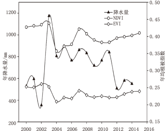
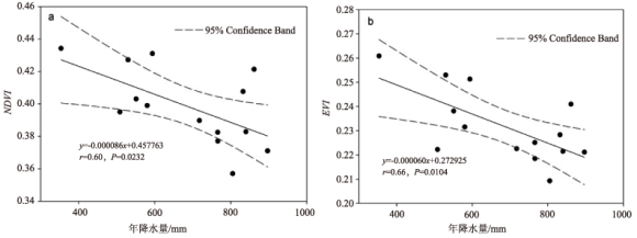
于泉洲, 梁春玲, 张祖陆 . 近40年来南四湖湿地NDVI变化特征及其控制因子分析[J]. 湖泊科学, 2014,26(3):456-464.
|
| [13] |
张祖陆, 沈吉, 孙庆义 , 等. 南四湖的形成及水环境演变[J]. 海洋与湖沼, 2002,33(3):314-321.
|
| [14] |
于泉洲, 孙京姐, 吕建树 , 等. 山东省南四湖湿地植被及其生物量初步研究[J]. 山东国土资源, 2011,27(4):21-25.
|
| [15] |
张祖陆, 辛良杰, 梁春玲 . 近50年来南四湖湿地水文特征及其生态系统演化过程分析[J]. 地理研究, 2007,26(5):957-959.
|
| [16] |
吴珂, 陈国浩, 蔡鹏 , 等. 山东西南部南四湖水位变化特征及其与气候要素的相关分析[J]. 冰川冻土, 2015,37(4):1087-1093.
doi: 10.7522/j.issn.1000-0240.2015.0121
|
| [17] |
方精云, 朴世龙, 贺金生 , 等. 近20年来中国植被活动在增强[J]. 中国科学C辑, 2003,33(6):554-565.
|
| [18] |
宋怡, 马明国 . 基于GIMMS AVHRR NDVI数据的中国寒旱区植被动态及其与气候因子的关系[J]. 遥感学报, 2008,12(3):499-506.
doi: 10.11834/jrs.20080367
|
| [19] |
侯美亭, 赵海燕, 王筝 , 等. 基于卫星遥感的植被NDVI 对气候变化响应的研究进展[J]. 气候与环境研究, 2013,18(3):353-364.
|
| [20] |
于泉洲, 梁春玲, 刘煜杰 , 等. 基于MODIS的山东省植被覆盖时空变化及其原因分析[J]. 生态环境学报, 2015,24(11):1799-1807.
|
| [21] |
姚鑫, 杨桂山, 万荣荣 . 水位变化对河流、湖泊湿地植被的影响[J]. 湖泊科学, 2014,26(6):813-821.
|
 ), 董杰1, 刘恩峰2, 周蕾3, 梁春玲4, 张怀珍1, 曹建荣1