| [1] |
覃先林, 李增元, 易浩若. 高空间分辨率卫星遥感影像树冠信息提取方法研究[J]. 遥感技术与应用, 2005,20(2):228-232.
|
| [2] |
林波, 刘庆. 四种亚高山针叶林树种的表型可塑性对不同光照强度的响应[J]. 生态学报, 2008,28(10):4665-4675.
|
| [3] |
Adam C, Vincent G, Everett A. Unmanned Aircraft Systems in Remote Sensing and Scientific Research:Classification and Considerations of Use[J]. Remote Sensing, 2012,4(6):1671-1692.
doi: 10.3390/rs4061671
|
| [4] |
李德仁, 李明. 无人机遥感系统的研究进展与应用前景[J]. 武汉大学学报:信息科学版, 2014,39(5):505-513.
|
| [5] |
樊仲谋. 摄影测树原理与技术方法研究[D]. 北京:北京林业大学, 2015.
|
| [6] |
吕晓君, 王君, 喻卫国, 等. 无人机监测林业有害生物初探[J]. 湖北林业科技, 2016,45(4):30-33.
|
| [7] |
Hernández J G, Ferreiro E G, Sarmento A, et al. Using high resolution UAV imagery to estimate tree variables in Pinus pinea plantation in Portugal[J]. Forest Systems, 2016, 25(2):eSC09.
doi: 10.5424/fs/2016252-08895
|
| [8] |
Panagiotidis D, Abdollahnejad A, Surový P, et al. Determining tree height and crown diameter from high-resolution UAV imagery[J]. International Journal of Remote Sensing, 2017,38(8-10):2392-2410.
doi: 10.1080/01431161.2016.1264028
|
| [9] |
罗辑, 杨忠, 杨清伟. 贡嘎山森林生物量和生产力的研究[J]. 植物生态学报, 2000,24(2):191-196.
|
| [10] |
冉飞, 梁一鸣, 杨燕, 等. 贡嘎山雅家埂峨眉冷杉林线种群的时空动态[J]. 生态学报, 2014,34(23):6872-6878.
doi: 10.5846/stxb201311252809
|
| [11] |
崔志祥, 申亚鹏, 马廷刚. PhotoScan近景影像数字三维建模中影像摄影方式的研究[J]. 测绘技术装备, 2016,18(4):10-12.
|
| [12] |
唐天琦. 面向对象的高分辨率遥感影像植被信息提取研究[D]. 长春:吉林大学, 2015.
|
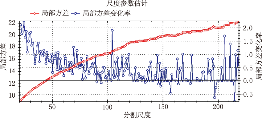
| [13] |
面向对象影像分析中的尺度问题研究[D]. 北京:中国科学院遥感应用研究所, 2003.
|
| [14] |
张俊, 朱国龙, 李妍. 面向对象高分辨率影像信息提取中的尺度效应及最优尺度研究[J]. 测绘科学, 2011,36(2):107-109.
|
| [15] |
Drǎguţ L, Tiede D, Levick S R. ESP:a tool to estimate scale parameter for multiresolution image segmentation of remotely sensed data[J]. International Journal of Geographical Information Science, 2010,24(6):859-871.
doi: 10.1080/13658810903174803
|
| [16] |
周春艳, 王萍, 张振勇, 等. 基于面向对象信息提取技术的城市用地分类[J]. 遥感技术与应用, 2008,23(1):31-35.
|
| [17] |
李莉. 面向对象的高分辨率遥感影像信息提取研究[D]. 成都:成都理工大学, 2012.
|
| [18] |
易凤佳, 李仁东, 常变蓉. 基于面向对象的长株潭地区遥感影像分类方法[J]. 华中师范大学学报:自科版, 2014,48(6):910-916.
|
| [19] |
何游云. 无人机遥感估测林木地上生物量的研究[D]. 北京:北京林业大学, 2016.
|
| [20] |
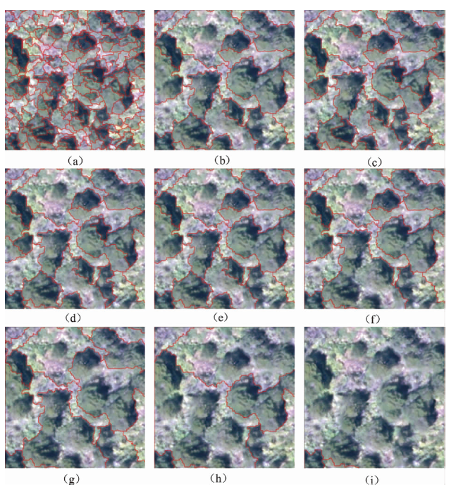
周艳飞, 张绘芳, 李霞, 等. 基于高分辨遥感数据的胡杨与柽柳树冠提取[J]. 遥感技术与应用, 2015,30(3):510-517.
doi: 10.11873/j.issn.1004-0323.2015.3.0510
|
 ), 林家元1(