| [1] |
牛德奎, 陈防, 张文元. 毛竹林平衡施肥与营养管理[M]. 北京: 科学出版社, 2013.
|
| [2] |
Xu Lin, Shi Yongjun, Zhou Guomo, et al. Structural development and carbon dynamics of Moso bamboo forests in Zhejiang Province,China[J]. Forest Ecology and Management, 2018,409:479-488.
doi: 10.1016/j.foreco.2017.11.057
|
| [3] |
Li C, Shi Y, Zhou G, et al. Effects of different management approaches on soil carbon dynamics in Moso bamboo forest ecosystems[J]. Catena, 2018,169:59-68.
doi: 10.1016/j.catena.2018.05.031
|
| [4] |
于世川, 张建国, 叶权平, 等. 抚育间伐对黄龙山辽东栎林分质量的影响[J]. 西北林学院学报, 2018,33(3):52-60.
|
| [5] |
刘健, 顾林彬, 余坤勇, 等. 毛竹林HJ-1HIS 专题信息的响应与识别[J]. 江西农业大学学报, 2016,38(6):1100-1109.
|
| [6] |
余坤勇, 许章华, 刘健, 等. “基于片层-面向类”的竹林信息提取算法与应用分析[J]. 中山大学学报:自然科学版, 2012,51(1):89-95.
|
| [7] |
Li M, Li C, Jiang H, et al. Tracking bamboo dynamics in Zhejiang,China,using time-series of Landsat data from 1990 to 2014[J]. International Journal of Remote Sensing, 2016,37(7):1714-1729.
doi: 10.1080/01431161.2016.1165885
|
| [8] |
高培军, 董大川, 何仁华, 等. 不同氮肥水平与毛竹林反射光谱的关系[J]. 北京林业大学学报, 2011,33(6):53-57.
|
| [9] |
官凤英, 邓旺华, 范少辉. 毛竹林光谱特征及其与典型植被光谱差异分析[J]. 北京林业大学学报, 2012,34(3):31-35.
|
| [10] |
王聪, 杜华强, 周国模, 等. 基于几何光学模型的毛竹林郁闭度无人机遥感定量反演[J]. 应用生态学报, 2015,26(5):1501-1509.
|
| [11] |
张宇, 岳祥华, 漆良华, 等. 利用异速生长关系和地统计方法估算武夷山南麓毛竹林生物量[J]. 生态学杂志, 2016,35(7):1957-1962.
|
| [12] |
万盼. 经营方式对甘肃小陇山锐齿栎天然林林分质量的影响[D]. 北京:中国林业科学研究院, 2018.
|
| [13] |
肖风劲, 欧阳华, 程淑兰, 等. 中国森林健康生态风险评价[J]. 应用生态学报, 2004,15(2):349-353.
|
| [14] |
周超凡, 王博恒, 王蔚炜, 等. 基于空间结构指数的黄龙山林区不同森林群落稳定性评价[J]. 中南林业科技大学学报, 2018,38(7):76-82.
|
| [15] |
王智勇, 董希斌, 张甜, 等. 抚育间伐强度对落叶松天然次生林林分结构及健康的影响[J]. 东北林业大学学报, 2018,46(11):1-7.
|
| [16] |
梅浩, 彭泰来, 桂来庭. 广东省国家级公益林质量评价[J]. 林业资源管理, 2019(2):15-20.
|
| [17] |
谢士琴, 赵天忠, 王威, 等. 结合影像纹理光谱与地形特征的森林结构参数反演[J]. 农业机械学报, 2017,48(4):125-134.
|
| [18] |
魏晶昱, 毛学刚, 方本煜, 等. 基于Landsat 8 OLI辅助的亚米级遥感影像树种识别[J]. 北京林业大学学报, 2016,38(11):23-33.
|
| [19] |
那日苏. 基于高光谱遥感的阿尔山市杜拉尔林场森林健康评价研究[D]. 呼和浩特:内蒙古师范大学, 2017.
|
| [20] |
麻坤. 于高光谱遥感的秦岭火地塘森林健康评价研究[D]. 杨凌:西北农林科技大学, 2013.
|
| [21] |
国家林业局. 中国森林资源报告(2009—2013)[M]. 北京: 中国林业出版社, 2014.
|
| [22] |
刘婧怡, 汤旭光, 常守志, 等. 森林叶面积指数遥感反演模型构建及区域估算[J]. 遥感技术与应用. 2014,29(1):18-25.
doi: doi:10.11873/j.issn.1004\|0323.2014.1.0018
|
| [23] |
Verstrate M M, Pinty B. Designing optimal spectral indexes for remote sensing applications[J]. IEEE Transactions On Geoscience and Remote Sensing, 1996,34(5):1254-1265.
doi: 10.1109/36.536541
|
| [24] |
桂子凡. 广州市森林健康风险研究[D]. 长沙:中南林业科技大学, 2013.
|
| [25] |
朱玉果, 杜灵通, 谢应忠, 等. 不同气象插值方法精度评估及对草地NPP估算的影响[J]. 水土保持研究, 2018,25(6):160-167.
|
| [26] |
张峰, 周广胜, 王玉辉. 基于CASA模型的内蒙古典型草原植被净初级生产力动态模拟[J]. 植物生态学报, 2008,32(4):786-797.
doi: 10.3773/j.issn.1005-264x.2008.04.007
|
| [27] |
陈国荣. 沿海防护林建设防护效益的遥感监测研究[D]. 福州:福建农林大学, 2010.
|
| [28] |
Hahn M B, Riederer A M, Foster S O. The Livelihood Vulnerability Index:A pragmatic approach to assessing risks from climate variability and change—A case study in Mozambique[J]. Global Environmental Change, 2009,19(1):74-88.
doi: 10.1016/j.gloenvcha.2008.11.002
|
| [29] |
姚雄, 余坤勇, 刘健, 等. 南方水土流失严重区的生态脆弱性时空演变[J]. 应用生态学报, 2016,27(3):735-745.
|
| [30] |
余坤勇. 林地生产力演变遥感监测研究[D]. 福州:福建农林大学, 2012.
|
| [31] |
封焕英. 毛竹林健康评价指标体系构建及实证研究[D]. 北京:中国林业科学研究院, 2014.
|
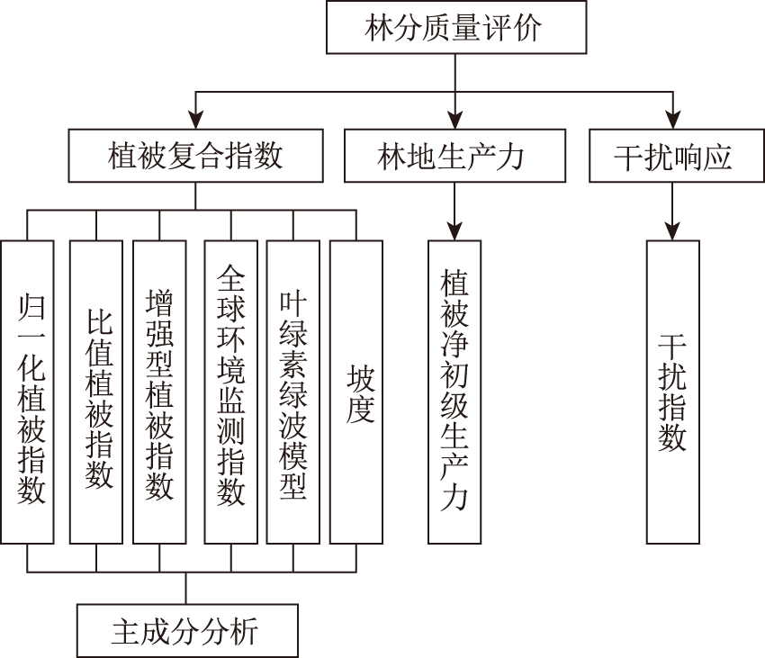
 ), 郝振帮1,3, 戴姗霖2, 杨柳青1,2, 刘健1,2,3, 余坤勇1,3(