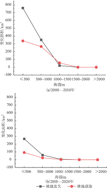
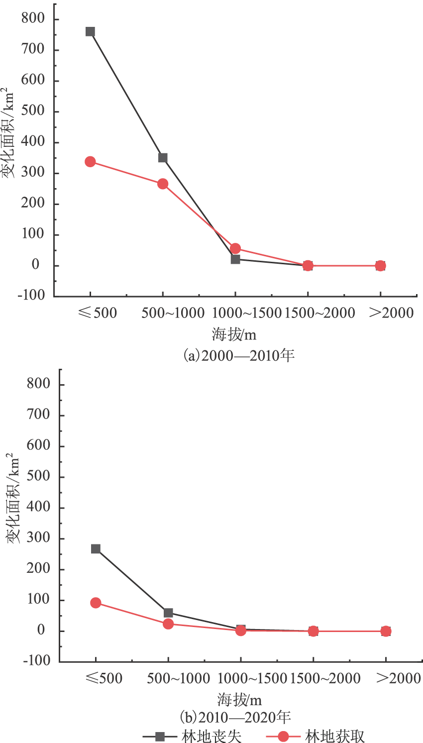
| [1] |
蒋敏元. 以生态建设为主体的新林业发展战略构想[J]. 林业科学, 2005(2):74-81.
|
| [2] |
王少丽, 高占义, 郭庭天. 灌区土壤盐渍化发展模拟预测与对策研究[J]. 灌溉排水学报, 2006(1):71-76.
|
| [3] |
Myneni R B, Keeling C D, Tucker C J, et al. Increased Plant Growth in the Northern High Latitudes From 1981 to 1991[J]. Nature:International Weekly Journal of Science, 1997,386(6626):689-702.
|
| [4] |
赵佩, 陈琼, 刘林山, 等. 柯西河流域森林覆盖度的空间分布及变化分析[J]. 生态科学, 2020,39(4):89-98.
|
| [5] |
王毅, 郭跃. 喀斯特地貌区植被覆盖与地形因子的空间关系分析——以贵州普定县为例[J]. 长江流域资源与环境, 2018,27(1):157-167.
|
| [6] |
熊俊楠, 张昊, 彭超, 等. 汶川地震灾区植被覆盖度变化与地形因子的关系[J]. 水土保持通报, 2018,38(3):24-31.
|
| [7] |
王树东, 欧阳志云, 张翠萍, 等. 海南岛主要森林类型时空动态及关键驱动因子[J]. 生态学报, 2012,32(23):7364-7374.
|
| [8] |
王一帆, 徐涵秋. 利用MODIS EVI时间序列数据分析福建省植被变化(2000—2017年)[J]. 遥感技术与应用, 2020,35(1):245-254.
|
| [9] |
侯秀英, 黄菲, 赵青, 等. 福建省森林丧失的时空格局演化及其驱动力机制[J]. 山地学报, 2020,38(6):829-840.
|
| [10] |
赵晓迪, 李凌超, 杨文涛, 等. 福建省县域森林转型社会经济影响因素分析[J]. 林业科学, 2019,55(8):147-156.
|
| [11] |
曹荣青, 胡喜生, 吴承祯. 福建省2000—2012年森林丧失量时空分布动态研究[J]. 山东农业大学学报:自然科学版, 2019,50(2):197-201.
|
| [12] |
苏全兴, 齐清琳, 姚历强, 等. 福建省森林康养发展现状与对策[J]. 防护林科技, 2020(10):72-75.
|
| [13] |
陈信旺, 万泉, 陈国瑞, 等. 林业与国土部门对林地界定的差异性分析——以福建省福安市为例[J]. 林业勘察设计, 2013(2):1-5.
|
| [14] |
Zimmerman C L, Runkle J R. Using ecological land units for conservation planning in a southwestern Ohio watershed[J]. Natural Areas Journal, 2010,30(1):27-38.
doi: 10.3375/043.030.0104
|
| [15] |
龙花楼, 刘永强, 李婷婷, 等. 生态用地分类初步研究[J]. 生态环境学报, 2015,24(1):1-7.
|
| [16] |
王静, 王雯, 祁元, 等. 中国生态用地分类体系及其1996-2012年时空分布[J]. 地理研究, 2017,36(3):453-470.
doi: 10.11821/dlyj201703005
|
| [17] |
管青春, 郝晋珉, 石雪洁, 等. 中国生态用地及生态系统服务价值变化研究[J]. 自然资源学报, 2018,33(2):195-207.
|
| [18] |
李彩霞, 邓帆, 龚杰, 等. 1990 年—2015年南宁土地利用动态变化时空特征分析[J]. 内蒙古科技与经济, 2019(5):43-47.
|
| [19] |
万安国, 王建强, 武可强. 江西省林地变化的时空特征与驱动因数分析[J]. 安徽农业科学, 2019,47(7):128-131.
|
| [20] |
李颖, 冯玉, 彭飞, 等. 基于地理探测器的天津市生态用地格局演变[J]. 经济地理, 2017,37(12):180-189.
|
| [21] |
梁彦庆, 官洋溢, 黄志英, 等. 京津冀土地绿色利用与经济增长耦合协调的时空异质性研究[J]. 生态与农村环境学报, 2020,36(12):1522-1531.
|
| [22] |
邢璐平, 方斌. 江苏省城镇化和生态环境的时空格局与协调发展研究[J]. 南京师大学报:自然科学版, 2018,41(3):131-137.
|
| [23] |
冯小燕, 朱文博, 张静静, 等. 基于地形梯度的淇河流域土地利用时空变异分析[J]. 农业现代化研究, 2019,40(4):601-611.
|
| [24] |
庞丽杰, 韩爱惠. 关于林地界定标准的探讨[J]. 林业资源管理, 2016(1):6-8.
|
 ), 闫国东, 陈瑾, 巫志龙, 胡喜生(