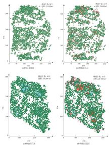
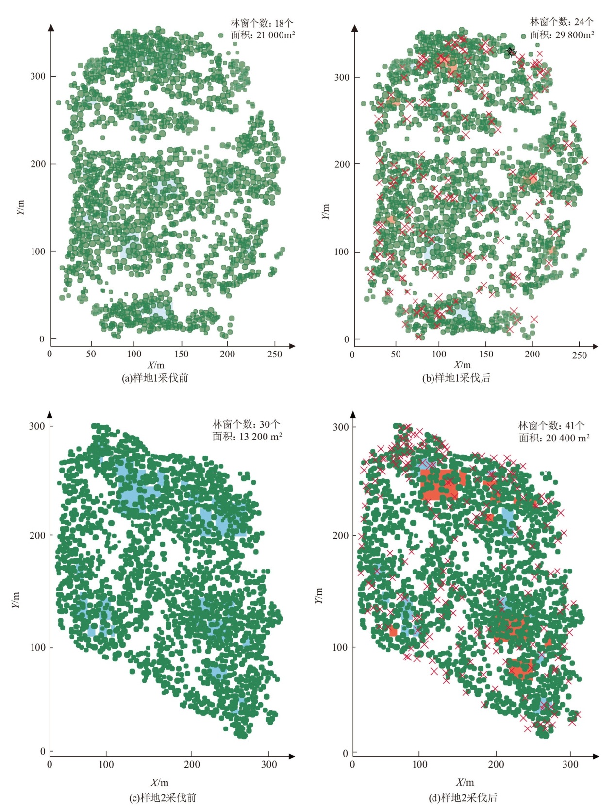
| [1] |
王志牧. 怀化市鹤城区针阔混交林林分结构规律研究[D]. 长沙: 中南林业科技大学, 2015.
|
| [2] |
彭辉, 周红敏, 惠刚盈. 萌生杉木林空间结构的二元分布特征[J]. 南京林业大学学报(自然科学版), 2017, 41(4):136-140.
doi: 10.3969/j.issn.1000-2006.201605065
|
| [3] |
徐奇刚. 湖南省栎类次生林林分空间结构及其对林下植被多样性的影响研究[D]. 长沙: 中南林业科技大学, 2018.
|
| [4] |
惠刚盈, 赵中华, 陈明辉. 描述森林结构的重要变量[J]. 温带林业研究, 2020, 3(1):14-20.
|
| [5] |
张志, 郭洋, 万舒珂, 等. 关帝山云杉次生林空间结构对林内光环境的影响[J]. 北京林业大学学报, 2023, 45(12):41-48.
|
| [6] |
王定晖, 索南才让, 于红妍, 等. 祁连山国家公园青海片区森林大样地生物多样性特征[J]. 西北植物学报, 2024, 44(12):1973-1979.
|
| [7] |
张毅锋, 汤孟平. 天目山常绿阔叶林空间结构动态变化特征. 生态学报, 2021, 41(5):1959-1969.
|
| [8] |
张峥男. 机载激光雷达亚热带森林结构参数及蓄积量分布估测研究[D]. 南京: 南京林业大学, 2018.
|
| [9] |
李鹏. 利用无人机和激光测绘技术提高矿山勘查精度的研究[J]. 世界有色金属, 2024,(24):141-143.
|
| [10] |
李梅, 刘清旺, 冯益明, 等. 无人机激光雷达人工林林分高估测模型分析[J]. 遥感学报, 2022, 26(12):2665-2678.
|
| [11] |
熊晓燕, 李彩霞, 柴国奇, 等. 联合UAV-LiDAR和GEDI数据的区域森林地上生物量估算[J]. 林业科学, 2025, 61(8):1-12.
|
| [12] |
刘清旺, 李世明, 李增元, 符利勇, 胡凯龙. 无人机激光雷达与摄影测量林业应用研究进展[J]. 林业科学, 2017, 53(7):134-148.
|
| [13] |
曾伟生, 孙乡楠, 王六如, 等. 基于机载激光雷达数据估计林分蓄积量及平均高和断面积[J]. 林业资源管理, 2020(2):79-86.
|
| [14] |
殷诗韵. 基于无人机多源遥感的银杏人工林冠层色素含量三维分布估测[D]. 南京: 南京林业大学, 2022.
|
| [15] |
廖丽华. 基于无人机多源遥感的桉树人工林表型性状提取及遗传特征分析[D]. 南京: 南京林业大学, 2022.
|
| [16] |
赵静, 李静, 柳钦火. 森林垂直结构参数遥感反演综述[J]. 遥感学报, 2013, 17(4):697-716.
|
| [17] |
霍林涛, 刘英, 杨雨图, 等. 基于多平台激光雷达数据集成的森林资源调查研究进展[J]. 世界林业研究, 2022, 35(6):49-55.
|
| [18] |
季波, 许浩, 何建龙, 等. 宁夏贺兰山青海云杉林土壤碳储量研究[J]. 生态科学, 2014, 33(5):920-925.
|
| [19] |
李妍, 李登武, 韩东辰. 贺兰山东坡青海云杉种群动态[J]. 浙江农林大学学报, 2014, 31(1):50-56.
|
| [20] |
郭肖. 贺兰山青海云杉林和油松林土壤细菌群落特征与群落构建[D]. 呼和浩特: 内蒙古大学, 2023.
|
| [21] |
李慧杰, 李婉婷, 王兵, 等. 宁夏贺兰山国家级自然保护区生态系统服务功能评估[J]. 林草资源研究, 2024(1):25-33.
|
| [22] |
杨壹, 邱开阳, 朱亚超, 等. 贺兰山中段不同海拔青海云杉林非根和根围土壤生态化学计量特征及影响因素. 生态学报, 2023, 43(19):7974-7986.
|
| [23] |
王智勇, 董希斌, 张甜, 等. 大兴安岭落叶松天然次生林林分结构特征[J]. 东北林业大学学报, 2018, 46(4):6-11.
|
| [24] |
沙欢, 梁咏亮, 彭妞, 等. 林窗大小对青海云杉林灌草层维管植物物种多样性的影响[J]. 生态学杂志, 2024, 43(8):2382-2394.
|
| [25] |
Looney C E, D'Amato A W, Palik B J, et al. Size-growth relationship,tree spatial patterns,and tree-tree competition influence tree growth and stand complexity in a 160-year red pine chronosequence[J]. Forest Ecology and Management, 2018, 424:85-94.
doi: 10.1016/j.foreco.2018.04.044
|
| [26] |
汤浩藩, 杨旭, 李子光, 等. 滇池面山锥连栎天然次生林空间结构特征及采伐优化研究[J]. 西南林业大学学报(自然科学), 2020, 40(4):80-86.
|
| [27] |
张子怡, 彭道黎, 陈铭捷. 不同年龄阶段华北落叶松人工林生产力对林分密度的响应[J/OL]. 应用生态学报, 2025, 36(7):1-11.
|
| [28] |
陈燕. 基于生态旅游开发的水东湾红树林景观评价与优化[D]. 北京: 中国林业科学研究院, 2016.
|
| [29] |
惠刚盈, GADOW K, 胡艳波, 等. 结构化森林经营[M]. 北京: 中国林业出版社, 2007.
|
| [30] |
李远发. 林分空间结构参数二元分布的研究[D]. 北京: 中国林业科学研究院, 2013.
|
| [31] |
张岗岗, 刘瑞红, 惠刚盈, 等. 林分空间结构参数N元分布及其诠释:以小陇山锐齿栎天然混交林为例[J]. 北京林业大学学报, 2019, 41(4):21-31.
|
| [32] |
胡美娟, 侯国林, 周年兴, 等. 庐山森林景观空间分布格局及多尺度特征[J]. 生态学报, 2015, 35(16):5294-5305.
|
| [33] |
赵维俊, 许尔文, 牛赟, 等. 祁连山典型流域青海云杉林林分空间结构对林下更新的影响[J]. 中南林业科技大学学报, 2025, 45(1):1-7.
|
| [34] |
张华, 黄琴, 赵传燕, 等. 青海云杉不同龄级立木的点格局分析[J]. 生态学杂志, 2016, 35(5):1182-1187.
|
| [35] |
DONG L B, WEI H Y, LIU Z G. Optimizing forest spatial structure with neighborhood-based indices:Four case studies from Northeast China[J]. Forests, 2020, 11(4):413.
doi: 10.3390/f11040413
|
| [36] |
路文燕, 董灵波, 田园, 等. 基于树种组成的大兴安岭天然林主要树种树高-胸径曲线研究[J]. 南京林业大学学报(自然科学版), 2023, 47(4):157-165.
doi: 10.12302/j.issn.1000-2006.202111034
|
| [37] |
王子纯, 李耀翔, 孟永斌, 王晨. 抚育间伐对针阔混交天然次生林生物量及碳密度的影响[J]. 东北林业大学学报, 2021, 49(2):66-72.
|
| [38] |
林富成, 王维芳, 门秀莉, 等. 兴安落叶松人工林空间结构优化[J]. 北京林业大学学报, 2021, 43(4):68-76.
|
| [39] |
黄维. 油松飞播林林分空间结构特征分析及优化调整[D]. 杨凌: 西北农林科技大学, 2022.
|
| [40] |
魏龙鑫. 阔叶红松林不同采伐强度下各林层树木生长及其与叶面积和生长效率的关系研究[D]. 北京: 北京林业大学, 2023.
|
| [41] |
周细斌, 周鸣惊, 唐志强, 等. 基于地空激光雷达的池杉人工林林分空间结构优化[J]. 湖南生态科学学报, 2024, 11(3):46-55.
|
 ), 胡杨2, 杨君珑1(