欢迎访问林草资源研究

林草资源研究 ›› 2024›› Issue (6): 153-158.doi: 10.13466/j.cnki.lczyyj.2024.06.018

• 研究简报 • 上一篇    

新一轮林地保护利用规划底数界定研究——以北京市延庆区为例

周维才1(), 王红春2(), 苏拉1, 孙红红2, 张璐瑶2, 蒋育昊2, 王端3   

  1. 1.北京林业工程咨询有限公司,北京 100714
    2.国家林业和草原局林草调查规划院,北京 100714
    3.中国林产品集团有限公司,北京 100125
  • 收稿日期:2024-10-16 修回日期:2024-12-02 出版日期:2024-12-28 发布日期:2025-04-18
  • 通讯作者: 王红春,教授级高级工程师,博士,主要从事森林经理研究工作。Email:780613367@qq.com
  • 作者简介:周维才,工程师,硕士,主要从事林草资源监测研究工作。Email:331563364@qq.com

The Defining Idea of Planning Base Data of the New Round of Forest Land Protection and Utilization Planning: A Case Study of Yanqing District of Beijing

ZHOU Weicai1(), WANG Hongchun2(), SU La1, SUN Honghong2, ZHANG Luyao2, JIANG Yuhao2, WANG Duan3   

  1. 1. Beijing Forestry Engineering Consulting Ltd.,Beijing,100714,China
    2. Academy of Inventory and Planning,National Forestry and Grassland Administration,Beijing 100714,China
    3. China National Forest Products Group Company Limited,Beijing 100125,China
  • Received:2024-10-16 Revised:2024-12-02 Online:2024-12-28 Published:2025-04-18

摘要:

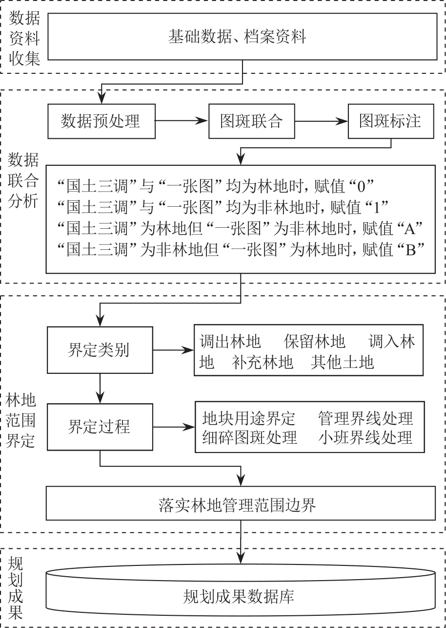
新一轮林地保护利用规划要求以第三次全国国土调查成果为统一底版,并以国土空间规划及“三区三线”划定成果为依据,明确林地管理边界。以北京市延庆区为例,林地保护利用规划底数界定思路为:依照政策规定、遵循技术要求、联合多源数据、界定林地范围,通过收集多源涉林矢量数据,基于ArcGIS平台,开展数据空间叠加等预处理,分层逐步联合与挂接属性,根据数据库内图斑的不同属性分析、筛选,逐一界定地块用途,处理边界交织和细碎地块融合,从而界定规划林地及补充林地的管理边界,确定新时期延庆区林地保护利用规划底数。该方法对于其他区域林地规划底数的界定具有一定的借鉴意义。

关键词: 林地保护利用, 规划底数, 界定思路, 数据融合

Abstract:

The new round of forest land protection and utilization planning requires taking the results of the third national land survey as the unified base map,and that the territorial spatial planning together with the three zones delineated by three lines for land use as the basis,to scientifically and reasonably clarify the management boundary of forest land.Taking Yanqing District of Beijing as an example,this study establishes a methodology for defining base data for forest land protection and utilization planning in accordance with policy regulations,following the technical requirements,uniting multi-source data,and defining the forest land boundaries.Multi-source forest-related vector data were collected,and then preprocessed through spatial overlay analysis,hierarchical layer union and linking attributes by using the ArcGIS platform.After that,land use is analyzed,screened,and defined one by one according to different attributes in the joint database.Boundaries are then processed and fragmented plots are merged alternately to define the management boundaries of planned forest land and supplementary forest land.Finally,the new base map for forest land protection and utilization planning in Yanqing District is obtained.This methodology provides a valuable reference for defining base data in forest land planning in other regions.

Key words: forest land protection and utilization, planning base data, defining idea, data fusion

中图分类号: