

FOREST RESOURCES WANAGEMENT ›› 2022, Vol. 0 ›› Issue (1): 106-113.doi: 10.13466/j.cnki.lyzygl.2022.01.013
• Technical Application • Previous Articles Next Articles
ZHOU Xiangbei( ), LI Chungan(), YU Zhu, CHEN Zhongchao, SU Kai
Received:2021-12-08
Revised:2021-12-22
Online:2022-02-28
Published:2022-03-31
Contact:
LI Chungan
E-mail:xiangbeizhou@st.gxu.edu.cn;gxali@126.com
CLC Number:
ZHOU Xiangbei, LI Chungan, YU Zhu, CHEN Zhongchao, SU Kai. Classification of Vertical Forest Structure of Overstory in Subtropical Forests Using Airborne Lidar Data[J]. FOREST RESOURCES WANAGEMENT, 2022, 0(1): 106-113.
Add to citation manager EndNote|Ris|BibTeX
URL: http://www.lyzygl.com.cn/EN/10.13466/j.cnki.lyzygl.2022.01.013
Tab.1
Basic information of the sample plot
| 森林类型 | 样地数/个 | 林分高 | 林分直径 | 林分蓄积量 | ||||||
|---|---|---|---|---|---|---|---|---|---|---|
| 均值/m | 变动系数/% | 均值/cm | 变动系数/% | 均值/(m3/hm2) | 变动系数/% | |||||
| 松树林 | 265 | 13.77 | 27.32 | 19.04 | 28.71 | 190.35 | 47.76 | |||
| 杉木林 | 233 | 10.80 | 28.51 | 12.17 | 28.90 | 191.57 | 47.77 | |||
| 桉树林 | 289 | 15.94 | 21.73 | 11.16 | 22.82 | 138.27 | 47.28 | |||
| 阔叶林 | 360 | 8.79 | 45.71 | 11.41 | 52.53 | 81.94 | 89.07 | |||
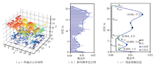
Fig.1
Pseudo-waves and extract canopy structure parameters generation using LiDAR point cloud


Fig.2
Schematic diagram of vertical structure type of overstory based on continuous canopy vertical profile (pseudo-wave)
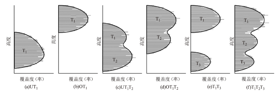
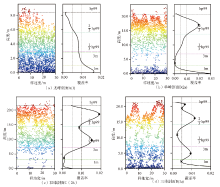
Fig.3
Pseudo-wave graphs of different peaks corresponding to classification rules

Tab.2
Classification rules of vertical structure of overstory based on continuous vertical canopy profile
| 编号 | 分类规则 | 类型 | |
|---|---|---|---|
| A(1) | Null | UT1 | |
| B(1a) | | OT1 | |
| B(1b) | | T1T3 | |
| B(2a) | (hp99/3< | OT1T2 | |
| B(2b) | (hp99/3< | OT1 | |
| B(2c) | (hp99/3< | T1T2T3 | |
| B(2d) | (hp99/3< | UT1T2 | |
| B(3a) | (3.0< | T1T2T3 | |
| B(3b) | (3.0< | OT1T2 | |
| B(3c) | (3.0< | UT1T2 | |
| B(3d) | (3.0< | OT1 | |
| B(3e) | (3.0< | OT1T2 | |
| B(3f) | (3.0< | OT1 | |
| B(3g) | (3.0< | UT1 | |
| B(4a) | (1.0< | T1T2T3 | |
| B(4b) | (1.0< | UT1T2 | |
| B(4c) | (1.0< | UT1T2 | |
| B(4d) | (1.0< | UT1 | |
| B(4e) | (1.0≤ | UT1 | |
| B(5a) | | UT1 | |
| B(5b) | | UT1T2 | |
| C(1a) | HPEAK1≥2/3 hp99 and HPEAK2≥hp99/3 and HUL2≥3.0 and(HLA1+HLA2)/HCS<0.65 | OT1 | |
| C(1b) | HPEAK1≥2/3hp99 and HPEAK2≥hp99/3 and HUL2≥3.0 and(HLA1+HLA2)/HCS≥0.65 | OT1T2 | |
| C(1c) | HPEAK1≥2/3hp99 and HPEAK2≥hp99/3 and HUL2<3.0 and hp99≥15.0 | T1T2T3 | |
| C(1d) | HPEAK1≥2/3hp99 and HPEAK2≥hp99/3 and HUL2<3.0 and hp99<15.0 | UT1T2 | |
| C(2a) | HPEAK1≥2/3hp99 and(3.0<HPEAK2≤hp99/3)and hp99≥15.0 and CMID<0.1 | T1T3 | |
| C(2b) | HPEAK1≥2/3hp99 and(3.0<HPEAK2≤hp99/3)and hp99≥15.0 and CMID≥0.1 | T1T2T3 | |
| C(2c) | HPEAK1≥2/3hp99 and(3.0<HPEAK2≤hp99/3)and hp99<15.0 | UT1T2 | |
| C(3a) | HPEAK1≥2/3hp99 and(1.0≤HPEAK2<3.0)and hp99≥15.0 and HLA1/HCS<0.65 and HLA2/HCS<0.35 | OT1 | |
| C(3b) | HPEAK1≥2/3hp99 and(1.0≤HPEAK2<3.0)and hp99≥15.0 and HLA1/HCS≥0.65 and HLA2/HCS<0.35 | OT1T2 | |
| C(3c) | HPEAK1≥2/3hp99 and(1.0≤HPEAK2<3.0)and hp99≥15.0 and HLA1/HCS<0.65 and HLA2/HCS≥0.35 and(HLA1+HLA2)/HCS≥0.80 | T1T2T3 | |
| C(3d) | HPEAK1≥2/3hp99 and(1.0≤HPEAK2<3.0)and hp99≥15.0 and HLA1/HCS<0.65 and HLA2/HCS≥0.35 and(HLA1+HLA2)/HCS<0.80 | T1T3 | |
| C(3e) | HPEAK1≥2/3hp99 and(1.0≤HPEAK2<3.0)and hp99<15.0 and HLA1/HCS≥0.65 | UT1T2 | |
| C(3f) | HPEAK1≥2/3hp99 and(1.0≤HPEAK2<3.0)and hp99<15.0 and HLA1/HCS<0.65 and HUL2<hp99/3 | UT1 | |
| C(3g) | HPEAK1≥2/3hp99 and(1.0≤HPEAK2<3.0)and hp99<15.0 and HLA1/HCS<0.65 and HUL2≥hp99/3 | OT1 | |
| C(4a) | (hp99/3≤HPEAK1<2/3hp99)and hp99≥15.0 and(HLA1+HLA2)/HCS≥0.8 | T1T2T3 | |
| C(4b) | (hp99/3≤HPEAK1<2/3hp99)and hp99≥15.0 and(HLA1+HLA2)/HCS<0.8 and HUL2<hp99/3 | UT1T2 | |
| C(4c) | (hp99/3≤HPEAK1<2/3hp99)and hp99≥15.0 and(HLA1+HLA2)/HCS<0.8 and HUL2≥hp99/3 | OT1T2 | |
| C(4d) | (hp99/3≤HPEAK1<2/3hp99)and hp99<15.0 and(HLA1+HLA2)/HCS<0.65 and HUL2<hp99/3 | UT1 | |
| C(4e) | (hp99/3≤HPEAK1<2/3hp99)and hp99<15.0 and(HLA1+HLA2)/HCS<0.65 and HUL2≥hp99/3 | OT1 | |
| C(4f) | (hp99/3≤HPEAK1<2/3hp99)and hp99<15.0 and(HLA1+HLA2)/HCS≥0.65 and HUL2<hp99/3 | UT1T2 | |
| C(4g) | (hp99/3≤HPEAK1<2/3hp99)and hp99<15.0 and(HLA1+HLA2)/HCS≥0.65 and HUL2≥hp99/3 | OT1T2 | |
| D(1a) | HPEAK3≥3.0 and(HLA1+HLA2+HLA3)/HCS≥0.80 | T1T2T3 | |
| D(1b) | HPEAK3≥3.0 and(HLA1+HLA2+HLA3)/HCS<0.80 | OT1T2 | |
| D(2a) | HPEAK3<3.0 and(HLA1+HLA2+HLA3)/HCS≥0.80 | T1T2T3 | |
| D(2b) | HPEAK3<3.0 and(HLA1+HLA2+HLA3)/HCS<0.80 | OT1T2 | |
Tab.3
Confusion matrix of classification of vertical canopy structure
| 类型 | 真实值 | 总数 | 用户精度/% | |||||
|---|---|---|---|---|---|---|---|---|
| (1)UT1 | (2)OT1 | (3)UT1T2 | (4)OT1T2 | (5)T1T3 | (6)T1T2 T3 | |||
| (1)UT1 | 190 | 0 | 1 | 0 | 0 | 0 | 191 | 99.5 |
| (2)OT1 | 5 | 534 | 0 | 2 | 0 | 2 | 543 | 98.3 |
| (3)UT1T2 | 9 | 0 | 67 | 6 | 1 | 1 | 84 | 79.8 |
| (4)OT1T2 | 17 | 5 | 6 | 164 | 1 | 0 | 193 | 85.0 |
| (5)T1T3 | 0 | 3 | 0 | 0 | 21 | 1 | 25 | 84.0 |
| (6)T1T2 T3 | 1 | 1 | 5 | 1 | 2 | 101 | 111 | 91.0 |
| 总数 | 222 | 543 | 79 | 173 | 25 | 105 | 1147 | |
| 生产者精度/% | 85.6 | 98.3 | 84.8 | 94.8 | 84.0 | 96.2 | ||
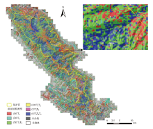
Fig.4
Classification of stand vertical structure in Daming Mountain

| [1] |
Zimblea D A, Evansb D L, Carlson G C, et al. Characterizing vertical forest structure using small-footprint airborne LiDAR[J]. Remote Sensing of Environment, 2003,87(2-3):171-182.
doi: 10.1016/S0034-4257(03)00139-1 |
| [2] |
Pommerening A, Sánchez Meador A J. Tamm review:Tree interactions between myth and reality[J]. Forest Ecology and Management, 2018,424:164-176.
doi: 10.1016/j.foreco.2018.04.051 |
| [3] | 惠刚盈, 赵中华, 陈明辉. 描述森林结构的重要变量[J]. 温带林业研究, 2020,3(1):14-20. |
| [4] | 方红亮. 森林垂直结构参数实测与遥感研究进展:以叶面积指数和聚集指数为例[J]. 科学通报, 2021,66(24):3141-3153. |
| [5] |
Bourdier T, Cordonnier T, Kunstler G, et al. Tree size inequality reduces forest productivity:an analysis combining inventory data for ten european species and a light competition model[J]. Plos One, 2016,11(3):e0151852.
doi: 10.1371/journal.pone.0151852 |
| [6] |
Krishna M P, Mohan M. Litter decomposition in forest ecosystems:a review[J]. Energy,Ecology and Environment, 2017,2(4):236-249.
doi: 10.1007/s40974-017-0064-9 |
| [7] | 楼一恺, 范忆, 戴其林, 等. 天目山常绿落叶阔叶林群落垂直结构与群落整体物种多样性的关系[J]. 生态学报, 2021,41(21):8568-8577. |
| [8] |
Hall S A, Burke I C, Box D O, Kaufmann M R, Stoker J M. Estimating stand structure using discrete-return lidar:an example from low density,fire prone ponderosa pine forests[J]. Forest Ecology and Management, 2005,208:189-209.
doi: 10.1016/j.foreco.2004.12.001 |
| [9] |
Baker P J, Wilson J S. A quantitative technique for the identification of canopy stratification in tropical and temperate forests[J]. Forest Ecology and Management, 2000,127:77-86.
doi: 10.1016/S0378-1127(99)00118-8 |
| [10] |
Bouvier M, Durrieu S, Fournier R A, et al. Generalizing predictive models of forest inventory attributes using an area-based approach with airborne LiDAR data[J]. Remote Sensing of Environment, 2015,156:322-334.
doi: 10.1016/j.rse.2014.10.004 |
| [11] | 李增元, 刘清旺, 庞勇. 激光雷达森林参数反演研究进展[J]. 遥感学报, 2016,20(5):1138-1150. |
| [12] | 刘浩, 张峥男, 曹林. 机载激光雷达森林垂直结构剖面参数的沿海平原人工林林分特征反演[J]. 遥感学报, 2018,22(5):872-888. |
| [13] |
Morsdorf F, Mårell A, Koetz B, et al. Discrimination of vegetation strata in a multi-layered Mediterranean forest ecosystem using height and intensity information derived from airborne laser scanning[J]. Remote Sensing of Environment, 2010,114(7):1403-1415.
doi: 10.1016/j.rse.2010.01.023 |
| [14] |
Leiterer R, Torabzadeh H, Furrer R, et al. Towards automated characterization of canopy layering in mixed temperate forests using airborne laser scanning[J]. Forests, 2015,6(11):4146-4167.
doi: 10.3390/f6114146 |
| [15] |
Latifi H, Heurich M, Hartig F, et al. Estimating over- and understorey canopy density of temperate mixed stands by airborne LiDAR data[J]. Forestry, 2016,89(1):69-81.
doi: 10.1093/forestry/cpv032 |
| [16] |
Kwon S, Jung H, Baek W, et al. Classification of forest vertical structure in south korea from aerial orthophoto and lidar data using an artificial neural network[J]. Applied Sciences, 2017,7(10):1046.
doi: 10.3390/app7101046 |
| [17] |
Adnan S, Maltamo M, Coomes D A, et al. A simple approach to forest structure classification using airborne laser scanning that can be adopted across bioregions[J]. Forest Ecology and Management, 2019,433:111-121.
doi: 10.1016/j.foreco.2018.10.057 |
| [18] |
Xu Zhaoshang, Zheng Guang, Moskal L M. Stratifying forest overstory for improving effective LAI estimation based on aerial imagery and discrete laser scanning data[J]. Remote Sensing, 2020,12(13):2126.
doi: 10.3390/rs12132126 |
| [19] |
Jarron L R, Coops N C, MacKenzie W H, et al. Detection of sub-canopy forest structure using airborne LiDAR[J]. Remote Sensing of Environment, 2020,244:111770.
doi: 10.1016/j.rse.2020.111770 |
| [20] | 骆期邦, 曾伟生, 贺东北 .等. 林业数表模型——理论、方法与实践[M]. 长沙: 湖南科学技术出版社, 2001. |
| [21] |
Parker G G, Brown N J. Forest canopy stratification-is it useful?[J]. American Naturalist, 2000,155(4):473-484.
doi: 10.1086/303340 |
| [22] | Neto S E N, Paula A D, Tagliaferre C, et al. Performance assessment of methodologies for vertical stratification in native forest[J]. Ciênc.Florest, 2018,28(4):1583-1591. |
| [23] |
Morsdorf F, Kötz B, Meier E, et al. Estimation of LAI and fractional cover from small footprint airborne laser scanning data based on gap fraction[J]. Remote Sensing of Environment, 2006,104(1):50-61.
doi: 10.1016/j.rse.2006.04.019 |
| [24] |
Muss J D, Mladenoff D J, Townsend P A, et al. A pseudo-waveform technique to assess forest structure using discrete lidar data[J]. Remote Sensing of Environment, 2011,115(3):824-835.
doi: 10.1016/j.rse.2010.11.008 |
| [1] | FU Anmin, GAO Xianlian, WU Fayun, GAO Jinping. A Method to Validate Airborne LIDAR CHM Producton Individual Tree Level [J]. FOREST RESOURCES WANAGEMENT, 2022, 0(1): 114-123. |
| [2] | YANG Dan, LI Chonggui, ZHANG Jiazheng. Research on Deep Learning Classification of Forest Types Based on Multi-temporal GF-1 Images [J]. FOREST RESOURCES WANAGEMENT, 2022, 0(1): 142-149. |
| [3] | WU Heng, XU Hui. Remote Sensing Retrieval and Calibration of Forest Vegetation Carbon Density Based on Time-series Data [J]. FOREST RESOURCES WANAGEMENT, 2021, 0(6): 43-51. |
| [4] | WANG Wei, YANG Jing, GAO Xianlian, ZENG Weisheng. Method and Enlightenment of 2020 Global Forest Resources Assessment Remote Sensing Survey [J]. FOREST RESOURCES WANAGEMENT, 2021, 0(6): 1-5. |
| [5] | XIANG Yingying. Characteristics of Ecosystem Changes in Beijing-Hebei Eco-water Source Conservation Forest Region from 2009 to 2018 [J]. FOREST RESOURCES WANAGEMENT, 2021, 0(6): 65-68. |
| [6] | TANG Jinhao, ZHANG Jialong, CHEN Liye, CHENG Tao. Research on Estimation of Aboveground Biomass and Scale Conversion for Pinus densata Mast [J]. FOREST RESOURCES WANAGEMENT, 2021, 0(6): 83-89. |
| [7] | LONG Fei, YUE Cairong, JIN Jing, LI Chungan, LUO Hongbin, XU Wanting. Study on the Inversion of Basal Area from Airborne LiDAR Data [J]. FOREST RESOURCES WANAGEMENT, 2021, 0(5): 62-69. |
| [8] | DU Zhi, CHEN Zhenxiong, MA Kaisen, LIU Ziwei, GU Xinggui. Estimating Standing Volume in Southern Collective Forest Region Based on the Unmanned Aerial Vehicle LiDAR Characteristic Variables [J]. FOREST RESOURCES WANAGEMENT, 2021, 0(4): 157-165. |
| [9] | XIAO Yue, XU Xiaodong, LONG Jiangping, LIN Hui. Research on Inversion of Forest Volume Based on Domestic High-Resolution Data [J]. FOREST RESOURCES WANAGEMENT, 2021, 0(3): 101-107. |
| [10] | ZHANG Diandai, WANG Xuemei. Comparison of Vegetation Classification Methods Based on High Resolution Remote Sensing Image [J]. FOREST RESOURCES WANAGEMENT, 2021, 0(3): 108-113. |
| [11] | QIU Shiping, WEI Mingxin, MA Yisha. Study on Automatic Extraction of Fast-Growing Eucalyptus Stand Parameters Based on UAV Remote Sensing Images [J]. FOREST RESOURCES WANAGEMENT, 2021, 0(3): 114-119. |
| [12] | LAN Yufang, SHI Xiaohua, MA Shengli, WANG Zhaoli, JIN Xin. Application of Middle-Resolution Satellite Remote Sensing Technology in Dynamic Monitoring of Forest Resources [J]. FOREST RESOURCES WANAGEMENT, 2021, 0(3): 154-159. |
| [13] | SUN Yujiang, LI Fengtao, CHEN Xiangqin, ZHANG Lei, YANG Ning, ZHENG Da. Application of UAV Aerial Photo Data in Forest Information Extraction [J]. FOREST RESOURCES WANAGEMENT, 2021, 0(3): 160-164. |
| [14] | ZHANG Yuwei, ZHANG Chao, WANG Juan, LI Huayu, BAI Mingxiong, YANG Anrong. Individual Tree Crown Width Extraction and DBH Estimation Model Based on UAV Remote Sensing [J]. FOREST RESOURCES WANAGEMENT, 2021, 0(3): 67-75. |
| [15] | LIN Shuangshuang, ZHONG Jiusheng, HE Xin, JIANG Li, DUAN Jiwei, DAI Renli, HE Zhiyuan. Extraction Method of Urban Forest Land Information Based on Spectral Information [J]. FOREST RESOURCES WANAGEMENT, 2021, 0(3): 96-100. |
| Viewed | ||||||
|
Full text |
|
|||||
|
Abstract |
|
|||||