

FOREST RESOURCES WANAGEMENT ›› 2021, Vol. 0 ›› Issue (5): 62-69.doi: 10.13466/j.cnki.lyzygl.2021.05.009
• Scientific Research • Previous Articles Next Articles
LONG Fei1( ), YUE Cairong1(), JIN Jing1, LI Chungan2, LUO Hongbin1, XU Wanting1
Received:2021-08-18
Revised:2021-09-29
Online:2021-10-28
Published:2021-11-29
Contact:
YUE Cairong
E-mail:1591035716@qq.com;cryue@163.com
CLC Number:
LONG Fei, YUE Cairong, JIN Jing, LI Chungan, LUO Hongbin, XU Wanting. Study on the Inversion of Basal Area from Airborne LiDAR Data[J]. FOREST RESOURCES WANAGEMENT, 2021, 0(5): 62-69.
Add to citation manager EndNote|Ris|BibTeX
URL: http://www.lyzygl.com.cn/EN/10.13466/j.cnki.lyzygl.2021.05.009
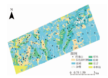
Fig.1
Schematic diagram of the sample plots distribution in the study area

Tab.1
Plot data statistics table
| 森林参数 | 针叶林 | 阔叶林 | |||||
|---|---|---|---|---|---|---|---|
| 范围 | 平均值 | 标准差 | 范围 | 平均值 | 标准差 | ||
| 林分平均高/m | 6.2~ 18.22 | 13.35 | 2.97 | 6.52~ 23.56 | 13.74 | 4.30 | |
| 蓄积量/(m3/hm2) | 57.93~387.2 | 17.59 | 63.76 | 21.28~317.13 | 139.23 | 76.61 | |
| 胸高断面积/(m2/hm2) | 15.20~ 50.21 | 25.60 | 6.70 | 3.92~ 36.69 | 19.25 | 7.46 | |
Tab.2
Calculation of typeⅠ error,typeⅡ error,total error and kp coefficient
| 滤波结果 | 误差计算公式 | |||||
|---|---|---|---|---|---|---|
| 地面点 | 非地面点 | TⅠ=b/(a+b) | Po=(a+d)/e | |||
| 参考 | 地面点 | a | b | TⅡ=c/(c+d) | Pe=((a+b)(a+c)+(c+d)(b+d))/e2 | |
| 非地面点 | c | d | TE=(b+c)/e | Kp=(Po-Pe)/(1-pe) | ||
Tab.3
Feature variable indexes extracted from ALS data
| 点云变量符号 | 变量描述 |
|---|---|
| Hmin/Hmax/ Hmean/ Hmad | 点云最低高度/最高高度/平均高度/中位数 |
| Hccr | 冠层起伏率;Hccr=(mean-min)/(max-min)。mean,min,max分别为每一统计单元内所有点的平均高度、最小高度、最大高度 |
| Hvar/Hstdv/Hskew/Hkurt/Hcv | 点云高度方差/标准差/偏态/峭度/变动系数 |
| H10,H20,H25, H30,H40,H50, H60,H70,H75, H80,H95,H99 | 点云高度百分位数,样地内所有归一化的激光雷达点云按高度进行排序,然后计算每一统计单元内X%的点所在的高度 |
| Hiq | 高度百分位数四分位数间距:Hiq=H75-H25 |
| D[0-9] | 密度变量(10个):将点云数据从低到高分成10个相同高度的切片,每层回波数的比例就是相应的密度变量 |
| CC | 郁闭度[ |
Tab.4
Sample plot information
| 样地号 | 坡度/ (°) | 郁闭度 | 点云个数/ point | 点云密度/ (point/m2) |
|---|---|---|---|---|
| 1 | 35.69 | 0.49 | 2312 | 0.93 |
| 2 | 26.11 | 0.58 | 4109 | 2.65 |
| 3 | 32.56 | 0.52 | 4590 | 2.24 |
| 4 | 25.69 | 0.65 | 2828 | 1.18 |
Tab.5
Accuracy evaluation of 4 filtering algorithms
| 样地 | 滤波方法 | TⅠ | TⅡ | TE | Kp/% |
|---|---|---|---|---|---|
| 1 | PMF | 0.20 | 0.04 | 0.19 | 74.70 |
| CSF | 0.09 | 0.08 | 0.09 | 72.40 | |
| PTIN | 0.11 | 0.08 | 0.01 | 69.00 | |
| IBF | 0.13 | 0.04 | 0.05 | 78.70 | |
| 2 | PMF | 0.08 | 0.23 | 0.20 | 51.49 |
| CSF | 0.04 | 0.19 | 0.16 | 59.12 | |
| PTIN | 0.02 | 0.21 | 0.17 | 57.78 | |
| IBF | 0.12 | 0.16 | 0.15 | 58.90 | |
| 3 | PMF | 0.20 | 0.17 | 0.18 | 53.73 |
| CSF | 0.20 | 0.16 | 0.17 | 54.90 | |
| PTIN | 0.17 | 0.11 | 0.12 | 64.90 | |
| IBF | 0.22 | 0.10 | 0.12 | 63.76 | |
| 4 | PMF | 0.09 | 0.21 | 0.13 | 71.17 |
| CSF | 0.13 | 0.13 | 0.13 | 71.60 | |
| PTIN | 0.05 | 0.26 | 0.13 | 71.00 | |
| IBF | 0.11 | 0.17 | 0.13 | 70.66 |
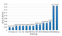
Fig.2
Importance of characteristic variables
Tab.6
Modeling and test accuracy of inversion model of BA
| 算法 | 建模精度 | 检验精度 | |||||||
|---|---|---|---|---|---|---|---|---|---|
| R2 | RMSE/(m2/hm2) | rRMSE/% | R2 | RMSE/(m2/hm2) | rRMSE/% | ||||
| RF | 0.77 | 3.99 | 17.76 | 0.66 | 3.27 | 14.73 | |||
| GBRT | 0.83 | 3.42 | 15.22 | 0.64 | 3.37 | 15.18 | |||

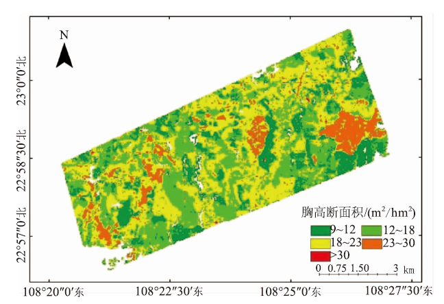
Fig.3
Inversion mapping of BA
| [1] |
Taubert F, Fischer R, Knapp N, et al. Deriving tree size distributions of tropical forests from iidar[J]. Remote Sensing, 2021, 13(1):131.
doi: 10.3390/rs13010131 |
| [2] | 郭庆华, 苏艳军, 胡天宇, 等. 激光雷达森林生态应用——理论、方法及实例[M]. 北京: 高等教育出版社, 2018: 12. |
| [3] | 李海奎, 雷渊才. 中国森林植被生物量和碳储量评估[M]. 北京: 中国林业出版社, 2010: 28. |
| [4] | 陈迪. 基于遥感技术的甘南州陆地生态系统NEP研究[D]. 甘肃:兰州大学, 2016. |
| [5] | 刘亚男. 基于多源遥感数据的森林地上生物量及净初级生产力估算研究[J]. 测绘学报, 2020, 49(12):1641. |
| [6] |
Paolo M, Vibrans A C, Mcroberts R E, et al. Methods for variable selection in LiDAR assisted forest inventories[J]. Forestry, 2017, 90:112-124.
doi: 10.1093/forestry/cpw041 |
| [7] | 郭庆华, 刘瑾, 陶胜利, 等. 激光雷达在森林生态系统监测模拟中的应用现状与展望[J]. 科学通报, 2014, 59:459-478. |
| [8] | 罗洪斌, 岳彩荣, 张国飞, 等. 机载激光雷达在不同区域尺度森林叶面积指数反演中的应用[J]. 西部林业科学, 2021, 50(4):33-40. |
| [9] | 王蕊, 邢艳秋, 尤号田, 等. 基于星载LiDAR波形数据的森林胸高断面积估测研究[J]. 西北林学院学报, 2014. 30(5):156-162. |
| [10] |
Strimbu V F, Ene L T, Gobakken T, et al. Post-stratified change estimation for large-area forest biomass using repeated ALS strip sampling[J]. Canadian Journal of Forest Research, 2017, 47(6):839-847.
doi: 10.1139/cjfr-2017-0031 |
| [11] |
White J C, Wulder M A, Varhola, Andrés, et al. A best practices guide for generating forest inventory attributes from airborne laser scanning data using an area-based approach[J]. Forestry Chronicle, 2013, 89(6):722-723.
doi: 10.5558/tfc2013-132 |
| [12] | 庞勇, 李增元, 陈尔学, 等. 激光雷达技术及其在林业上的应用[J]. 林业科学, 2005(3):129-136. |
| [13] |
Naesset E. Determination of mean tree height of forest stands using airborne laser scanner data[J]. ISPRS journal of photogrammetry and remote sensing, 1997, 52(2):49-56.
doi: 10.1016/S0924-2716(97)83000-6 |
| [14] |
Nelson R, Krabill W, Tonelli J. Estimating forest biomass and volume using airbone laser data[J]. Remote Sensing of Environment, 1988, 24(2):247-267.
doi: 10.1016/0034-4257(88)90028-4 |
| [15] |
Naesset E. Estimating timber volume of forest stands using airborne laser scanner data[J]. Remote Sensing of Environment, 1997, 61(2):246-253.
doi: 10.1016/S0034-4257(97)00041-2 |
| [16] |
Silva C A, Carine K, Hudak A T, et al. Modeling and mapping basal area of Pinus taeda L.plantation using airborne LiDAR data[J]. Anais da Academia Brasileira de Ciências, 2017, 89(3):1895-1905.
doi: 10.1590/0001-3765201720160324 |
| [17] |
Ferreiro G, Aranda D, Miranda A. Estimation of stand variables in Pinus radiata D.Don plantations using different LiDAR pulse densities[J]. Forestry, 2012, 85(2):281-292.
doi: 10.1093/forestry/cps002 |
| [18] | Dash J P, Marshall H M, Brian R. Methods for estimating multivariate stand yields and errors using k-NN and aerial laser scanning[J]. Forestry, 2015(2):237-247. |
| [19] |
Lefsky M A, Cohen W B, Acker S A, et al. Lidar Remote Sensing of the Canopy Structure and Biophysical Properties of Douglas-Fir Western Hemlock Forests[J]. Remote Sensing of Environment, 1999, 70(3):339-361.
doi: 10.1016/S0034-4257(99)00052-8 |
| [20] | 赵勋, 岳彩荣, 李春干, 等. 基于机载LiDAR数据估测林分平均高[J]. 林业科学研究, 2020, 33(4):59-66. |
| [21] |
Zhao Xiaoqian, Guo Qinghua, Su Yanjun, et al. Improved progressive TIN densification filtering algorithm for airborne LiDAR data in forested areas[J]. ISPRS Journal of Photogrammetry and Remote Sensing, 2016, 117:79-91.
doi: 10.1016/j.isprsjprs.2016.03.016 |
| [22] |
Zhang Keqi, Chen Shucheng, Whitman D, et al. A progressive morphological filter for removing nonground measurements from airborne LIDAR data[J]. IEEE transactions on geoscience and remote sensing, 2003, 41(4):872-882.
doi: 10.1109/TGRS.2003.810682 |
| [23] |
Evans J S, Hudak A T. A multiscale curvature algorithm for classifying discrete return LiDAR in forested environments[J]. IEEE Transactions on Geoscience and Remote Sensing, 2007, 45(4):1029-1038.
doi: 10.1109/TGRS.2006.890412 |
| [24] | 赵勋, 岳彩荣, 李春干, 等. 基于机载LiDAR点云数据森林郁闭度估测[J]. 遥感技术与应用, 2020, 35(5):1136-1145. |
| [25] | 曹林, 代劲松, 徐建新, 等. 基于机载小光斑LiDAR技术的亚热带森林参数信息优化提取[J]. 北京林业大学学报, 2014, 36(5):13-21. |
| [26] | 张加龙, 胥辉, 陆驰. 应用Landsat8 OLI和GBRT对高山松地上生物量的估测[J]. 东北林业大学学报, 2018, 46(8):25-30. |
| [27] | 吴立志, 陈振南, 张鹏. 基于随机森林算法的城市火灾风险评估研究[J/OL]. 灾害学:1-10 [2021-09-25]. http://kns.cnki.net/kcms/detail/61.1097.P.20210729.1558.014.html . |
| [28] |
Friedman J H. Stochastic gradient boosting[J]. Computational Statistics & Data Analysis, 2002, 38(4):367-378.
doi: 10.1016/S0167-9473(01)00065-2 |
| [29] | 高婷, 李卫忠, 赵鹏祥, 等. 基于ArboLiDAR的大野口林区森林参数估测[J]. 西北林学院学报, 2017, 32(4):172-177. |
| [30] | 郝红科. 基于机载激光雷达的森林参数反演研究[D]. 西北农林科技大学, 2019. |
| [1] | HE Peng, CHEN Zhenxiong, LIU Xianzhao. Developing Stand Basal Area Growth Models for Pinus massoniana and Cunninghamia lanceolata in Hunan Province [J]. FOREST RESOURCES WANAGEMENT, 2021, 0(5): 56-61. |
| [2] | WU Xuping, LV Yong, ZHANG Xiongqing, YI Xuan, ZHU Guangyu. Research on Growth Mixed Effect Model for Basal Area of Cunninghamia lanceolata Plantation Based on Site Factors [J]. FOREST RESOURCES WANAGEMENT, 2021, 0(2): 75-82. |
| [3] | LIU Hongsheng, ZANG Hao, HUANG Jincheng, LI Qi, OUYANG Xunzhi, WEI Chunhua, NING Jinkui. The Influence of Forest-layer on the Individual Growth of Main Species in the Broad-leaved Secondary Forest in Southern Jiangxi [J]. FOREST RESOURCES WANAGEMENT, 2020, 0(4): 28-33. |
| [4] | HAN Rui, WU Dasheng, FANG Luming, HUANG Yuling. Estimation of Forest Reserves Based on Boruta and Extra-trees Methods [J]. FOREST RESOURCES WANAGEMENT, 2020, 0(4): 127-133. |
| [5] | GONG Zhaosong, ZENG Siqi, HE Dongbei, LONG Shisheng, JIANG Xingyan. A Study on the Basal Area Growth Model of Phoebe zhennan Secondary Forest in Hunan Province [J]. FOREST RESOURCES WANAGEMENT, 2020, 0(2): 87-93. |
| [6] | ENG Qilong, CHEN Zhefu, CHEN Duanlv. A Study on the Growth Model of Individual Trees in Natural Mixed Forests of Oak and Pinus Massoniana in Hunan [J]. FOREST RESOURCES WANAGEMENT, 2020, 0(2): 94-102. |
| [7] | CAI Linfei, WU Dasheng, FANG Luming, ZHENG Xinyu. Tree Species Identification Using XGBoost Based on GF-2 Images [J]. FOREST RESOURCES WANAGEMENT, 2019, 0(5): 44-51. |
| [8] | XIAO Yundan, HOU Ruixia, JI ping. Linking Model of Stand Basal Area from Forest Resource Inventory Data for Management and Systematic Plots [J]. FOREST RESOURCES WANAGEMENT, 2017, 0(2): 34-39. |
| [9] | ZHOU Mei, WANG Xinhua, LI Chungan, YANG Chengling. Analysis of Statistics Difference of Stand Parameters between Angle Measuring and Square Sample Plot [J]. FOREST RESOURCES WANAGEMENT, 2017, 0(2): 40-45. |
| [10] | LI Chunming, DU Jishan, ZHANG Huiru. Study on the Growth Trend of the Basal Area and Volume of Larix olgensis Plantation [J]. FOREST RESOURCES WANAGEMENT, 2007, 0(3): 90-93. |
| Viewed | ||||||
|
Full text |
|
|||||
|
Abstract |
|
|||||