

FOREST RESOURCES WANAGEMENT ›› 2022, Vol. 0 ›› Issue (1): 114-123.doi: 10.13466/j.cnki.lyzygl.2022.01.014
• Technical Application • Previous Articles Next Articles
FU Anmin( ), GAO Xianlian(), WU Fayun, GAO Jinping
Received:2021-12-16
Revised:2022-01-04
Online:2022-02-28
Published:2022-03-31
Contact:
GAO Xianlian
E-mail:anmin_fu@163.com;248745622@qq.com
CLC Number:
FU Anmin, GAO Xianlian, WU Fayun, GAO Jinping. A Method to Validate Airborne LIDAR CHM Producton Individual Tree Level[J]. FOREST RESOURCES WANAGEMENT, 2022, 0(1): 114-123.
Add to citation manager EndNote|Ris|BibTeX
URL: http://www.lyzygl.com.cn/EN/10.13466/j.cnki.lyzygl.2022.01.014

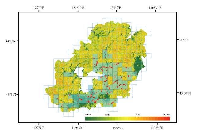
Fig.1
The CHM map of study area
Tab.1
Specification of forestry survey application
| 指标 | 定位系统 |
|---|---|
| 基站定位精度 | 水平精度优于5cm,高程精度优于10cm |
| 基站采样间隔 | 1s |
| 移动站 | 移动站距离基站小于30km |
| 移动站静态测量 | 静态30min以上 |
| 全站仪测距精度 | 精度优于0.5cm |
| 指标 | 林木检尺 |
| 检尺范围 | 胸径大于5cm |
| 胸径测量 | 胸径等于或大于20cm的树木,胸径测量误差小于5%;胸径小于20cm的树木,胸径测量误差小于0.5cm。 |
| 树高测量 | 树高10m以下误差小于1m;树高10m以上不超过10% |
| 检尺株数 | 大于或等于8cm的应检尺株数不允许有误差。小于8cm的应检尺株数,允许误差3株。 |
| 冠幅测量 | 误差小于15%(东西冠幅、南北冠幅) |
| 枝下高测量 | 误差小于20% |
| 郁闭度测量 | 误差小于0.05 |
Tab.2
Specification for airborne LIDAR data collection
| 设备名称 | 设备类型 | 主要指标 | 参数指标 |
|---|---|---|---|
| 飞机 | 塞斯纳208B | 飞行速度 | 260 km/h |
| 飞行高度 | 2300/2100 m | ||
| 平均地面高程 | 400/200 m | ||
| 激光雷达 载荷 | RIEGL-VQ-1560i | 脉冲频率 | 1000 kHz |
| 视场角FOV | 58° | ||
| 激光发散度 | ≤0.25 mrad | ||
| 激光波长 | 1064 nm | ||
| 扫描频率 | 207 Hz | ||
| 扫描幅宽 | 2129 m | ||
| 点密度 | 10 pts/m2 | ||
| 旁向重叠度 | 25% | ||
| IMU系统 | POSAV610 | 采样频率 | 200Hz |
| 横滚/俯仰 | 0.005° | ||
| 航偏 | 0.008° | ||
| GNSS定位系统 (飞机/地面) | CORS站 | 采样频率 | 1Hz |
| 中海达GPS | 采样频率 | 1Hz | |
| 机载GPS | 采样频率 | 1Hz |
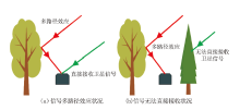
Fig.2
The schematic diagram of multipath interference and non-line-of-sight reception of GNSS satellite reception signal

Tab.3
LIDAR products classification
| 等级 | 名称 | 内容 | 数据量 |
|---|---|---|---|
| 0级 | 激光雷达原始数据 | 从激光雷达载荷(LIDAR)、惯性导航(IMU)系统和GNSS系统(飞机/地面)导出的原始数据 | 2.3TB |
| 1A级 | 激光雷达初级定位数据 | 将机载GNSS和IMU数据,联合地面参照站数据进行差分技术处理,对航线定位定向进行联合精结算;将精解算姿态和定位数据赋给每个激光脉冲。 | 4.2TB |
| 1B级 | 激光雷达去噪数据 | 剔除明显噪声点后的数据。 | 4.2TB |
| 2级 | 激光点云几何精纠正数据 | 以架构航线为基准,经航带间匹配,整体平差后的数据。 | 2.7TB |
| 3级 | 激光雷达分类数据 | 对激光点云数据进行滤波和分类,区分地面点和非地面点的数据。 | 2.7TB |
| 4级 | CSM/DTM/CHM数据 | 经点云数据空间差值或格网统计获取CSM和DTM数据,两者之差获取CHM数据。 | 160G |

Fig.3
The workflow of CHM accuracy assessment
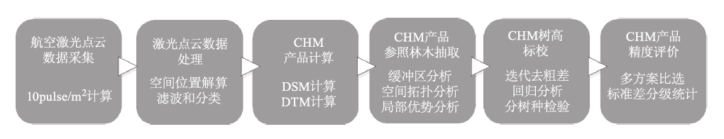

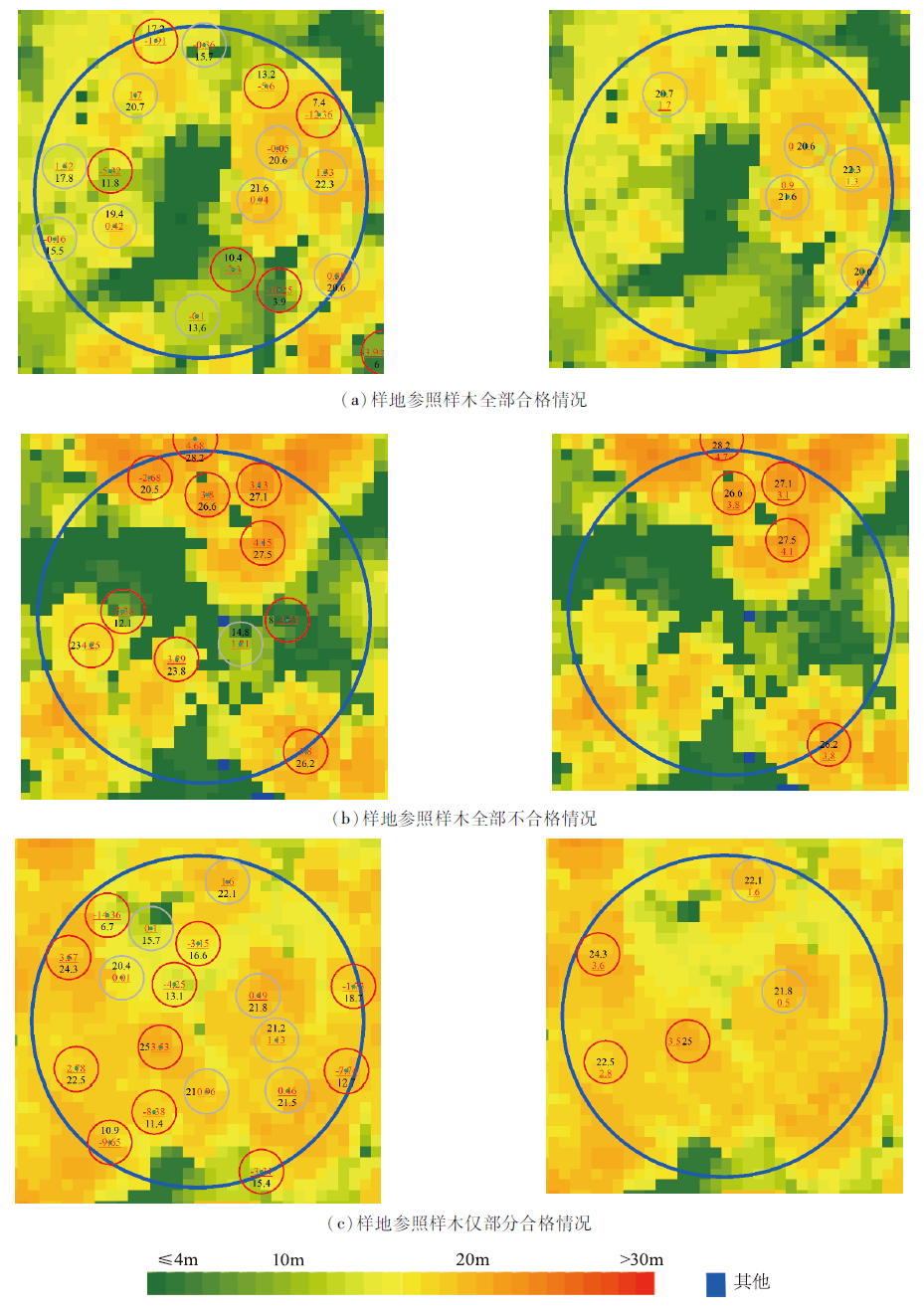
Fig.4
Sampling distribution map of upper story based on spatial analysis of plan 5 in table 5
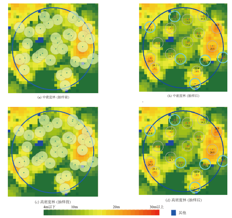
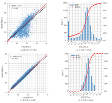
Fig.5
The scatter plot and difference histogram of the height of the ground reference sample tree and the corresponding CHMmax with 2m-radius circle spatial buffer(before and after multi-iteration for removing outliers)
Tab.4
Analysis of CHM tree height and precision calibration
| 编码 | 树种(组) | 主要树种 | 株数/株 | 最小值 | 最大值 | 平均值 | 标准差 |
|---|---|---|---|---|---|---|---|
| 1 | 天然针叶林Ⅰ | 红松(包括赤柏松)、云杉(包括鱼鳞云杉、红皮云杉) | 675 | -1.5 | 3.0 | 0.7 | 1.0 |
| 2 | 天然针叶林Ⅱ | 臭松、樟子松(包括樟子松、赤松、黑松、油松、长白松)、其它针叶 | 488 | -1.6 | 3.0 | 0.6 | 0.9 |
| 3 | 天然针叶林Ⅲ | 落叶松 | 953 | -1.5 | 3.0 | 0.9 | 0.8 |
| 4 | 天然阔叶林Ⅰ | 水曲柳、胡桃楸、黄菠萝 | 120 | -1.5 | 3.0 | 0.8 | 1.1 |
| 5 | 天然阔叶林Ⅱ | 椴树、枫桦 | 419 | -1.6 | 3.0 | 0.7 | 1.0 |
| 6 | 天然阔叶林Ⅲ | 柞树、黑桦 | 601 | -1.6 | 2.9 | 0.3 | 1.0 |
| 7 | 天然阔叶林Ⅳ | 色树、榆树 | 205 | -1.6 | 3.0 | 0.6 | 1.0 |
| 8 | 天然阔叶林Ⅴ | 杨树、白桦 | 1530 | -1.6 | 3.0 | 0.7 | 0.9 |
| 9 | 天然落叶林Ⅵ | 其它阔叶 | 286 | -1.6 | 2.8 | 0.4 | 1.0 |
| 10 | 人工针叶林Ⅰ | 人工红松(包括赤柏松)、人工云杉(包括鱼鳞云杉、红皮云杉) | 152 | -1.6 | 2.9 | 1.0 | 0.7 |
| 11 | 人工针叶林Ⅱ | 人工樟子松(包括樟子松、赤松、黑松、油松、长白松)、人工臭松、其它针叶 | N/A | N/A | N/A | N/A | N/A |
| 12 | 人工针叶林Ⅲ | 人工落叶松 | 410 | -1.5 | 3.0 | 1.3 | 0.8 |
| 13 | 人工阔叶林Ⅰ | 人工杨树(包括人工朝鲜柳) | N/A | N/A | N/A | N/A | N/A |
| 14 | 人工阔叶林Ⅱ | 人工其他阔叶林 | 17 | -1.5 | 2.7 | 0.3 | 1.2 |
| 总计 | 5856 | -1.6 | 3 | 0.7 | 1.0 |
Tab.5
Reference tree sampling plan and its grading statistics table by different standard deviation
| 抽样 方案 | 缓冲区大小 /m | 样地半径 /m | 株数 参数 | 小计 | -3σ 以下 | -3σ | -2σ | ±σ | +2σ | +3σ | +3σ 以上 |
|---|---|---|---|---|---|---|---|---|---|---|---|
| (1) | 5 | 10 | N/A | 714 | 17 | 6 | 32 | 389 | 126 | 75 | 69 |
| 100% | 2.4% | 0.8% | 4.5% | 54.5% | 17.6% | 10.5% | 9.7% | ||||
| (2) | 4 | 10 | N/A | 1017 | 28 | 13 | 58 | 591 | 153 | 95 | 79 |
| 100% | 2.8% | 1.3% | 5.7% | 58.1% | 15.0% | 9.3% | 7.8% | ||||
| (3) | 3 | 10 | N/A | 1601 | 84 | 27 | 112 | 915 | 235 | 124 | 104 |
| 100% | 5.2% | 1.7% | 7.0% | 57.2% | 14.7% | 7.7% | 6.5% | ||||
| (4) | 2 | 10 | N/A | 3366 | 454 | 115 | 286 | 1830 | 377 | 176 | 128 |
| 100% | 13.5% | 3.4% | 8.5% | 54.4% | 11.2% | 5.2% | 3.8% | ||||
| (5) | 2 | 15 | N/A | 7873 | 1302 | 351 | 708 | 4108 | 787 | 340 | 277 |
| 100% | 16.5% | 4.5% | 9.0% | 52.2% | 10.0% | 4.3% | 3.5% | ||||
| (6) | 2 | 15 | 5株 | 2195 | 16 | 29 | 117 | 1264 | 362 | 206 | 201 |
| 100% | 0.7% | 1.3% | 5.3% | 57.6% | 16.5% | 9.4% | 9.2% |

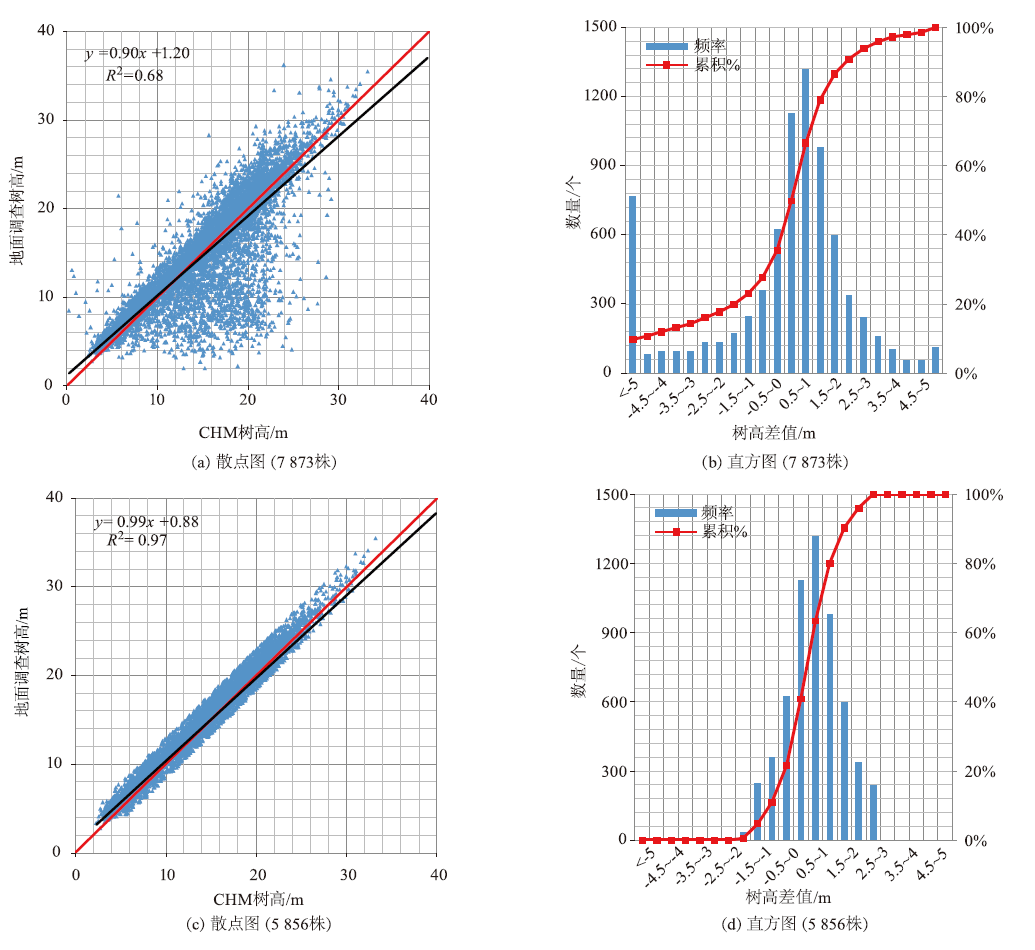
Fig.6
Sampling distribution map of upper story based on spatial analysis of plan 5 and plan 6 in table 5
| [1] | Erik Næsset, Gobakken T, Holmgren J, et al. Laser scanning of forest resources:The nordic experience[J]. Scandinavian Journal of Forest Research, 2004,18:482-499. |
| [2] | 庞勇, 赵峰, 李增元, 等. 机载激光雷达平均树高提取研究[J]. 遥感学报, 2008(1):152-158. |
| [3] | Nelson R. How did we get here? An early history of forestry lidar[J]. Canadian Journal of Remote Sensing, 2014,39:6-17. |
| [4] | 李增元, 陈尔学, 高志海, 等. 中国林业遥感技术与应用发展现状及建议[J]. 中国科学院院刊—“从空间看地球:遥感发展五十年”专辑, 2013,28(S0):132-144. |
| [5] | 曾伟生, 孙乡楠, 王六如, 等. 基于机载激光雷达数据估计林分蓄积量及平均高和断面积[J]. 林业资源管理, 2020(2):79-86. |
| [6] |
Pang Yong, Wang Weiwei, Du Liming, et al. Nystrym-based spectral clustering using airborne LiDAR point cloud data for individual tree segmentation[J]. International Journal of Digital Earth, 2021,14(10):1452-1476.
doi: 10.1080/17538947.2021.1943018 |
| [7] | 李增元, 庞勇, 刘清旺. 激光雷达森林参数反演技术与方法[M]. 北京: 科学出版社, 2015. |
| [8] | Demetrios Gatziolis, Jeremy S Fried, Vicente S Monleon. Challenges to estimating tree height via LiDAR in closed-canopy forests:A Parable from Western Oregon[J]. Forest Science, 2010,56:139-155. |
| [9] |
Kraus K, Pfeifer N. Determination of terrain models in wooded areas with airborne laser scanner data[J]. ISPRS Journal of Photogrammetry and Remote Sensing, 1998,53(4):193-203.
doi: 10.1016/S0924-2716(98)00009-4 |
| [10] |
White J C, Wulder M A, Varhola Andrés, et al. A best practices guide for generating forest inventory attributes from airborne laser scanning data using an area-based approach[J]. The Forestry Chronicle, 2013,89(6):722-723.
doi: 10.5558/tfc2013-132 |
| [11] | 国家林业局,吉林省人民政府,黑龙江省人民政府. 东北虎豹国家公园总体规划[EB/OL].(2018-09-20)[2021-11-10], http://www.forestry.gov.cn/uploadfile/main/2018-3/file/2018-3-9-599430e5ec1249bab08927453227ff14.pdf. |
| [12] | Mcgaughey R J, Ahmed K, Andersen H E, et al. Effect of occupation time on the horizontal accuracy of a mapping-grade GNSS receiver under dense forest canopy[J]. Photogrammetric Engineering & Remote Sensing, 2017,83:861-868. |
| [1] | CHEN Zhoujuan, CHENG Guang, BU Yuankun, HUANG Wei, CHEN Jiahui, LI Weizhong. Single Tree Parameters Extraction of Broad-Leaved Forest Based on UAV Tilting Photography [J]. FOREST RESOURCES WANAGEMENT, 2022, 0(1): 132-141. |
| [2] | LONG Fei, YUE Cairong, JIN Jing, LI Chungan, LUO Hongbin, XU Wanting. Study on the Inversion of Basal Area from Airborne LiDAR Data [J]. FOREST RESOURCES WANAGEMENT, 2021, 0(5): 62-69. |
| [3] | LIU Yingchun, WU Fayun, SUN Zhongqiu, FU Anmin, GAO Jinping, GAO Xianlian, GAO Jianxin, CUI Chenyan, CHAO Zhi. Comprehensive Experiment Substitute for Multi-Payload Data of Terrestrial Ecosystem Carbon Inventory Satellite in Hainan [J]. FOREST RESOURCES WANAGEMENT, 2021, 0(4): 138-148. |
| [4] | PU Ying, ZENG Weisheng, YANG Fan. Tree Height-Diameter Regression Models Development and One-Variable Tree Volume Tables Examination in Beijing [J]. FOREST RESOURCES WANAGEMENT, 2021, 0(3): 62-66. |
| [5] | BAI Mingxiong, ZHANG Chao, CHEN Qi, WANG Juan, LI Huayu, SHI Xiaorong, TIAN Xianyun, ZHANG Yuwei. Study on the Extraction of Individual Tree Height Based on UAV Visual Spectrum Remote Sensing [J]. FOREST RESOURCES WANAGEMENT, 2021, 0(1): 164-172. |
| [6] | WU Simin, SUN Hua, LIN Hui. Research on LiDAR Stand Average High Inversion Method Based on Auto-adaptive Threshold and Peak Value [J]. FOREST RESOURCES WANAGEMENT, 2021, 0(1): 61-68. |
| [7] | XU Can, JIANG Tengda. A Method of Estimating Forest Stock Volume Parameters from Airborne LiDAR Data [J]. FOREST RESOURCES WANAGEMENT, 2020, 0(3): 105-110. |
| [8] | ZENG Weisheng. Analysis on the Impact of Stock Volume Estimation Based on Tree Height-DBH Model at Population and Stand Level [J]. FOREST RESOURCES WANAGEMENT, 2019, 0(6): 38-41. |
| [9] | LIU Jiangjun, GAO Haili, FANG Luming, ZHENG Xinyu, JIANG Guangyu. Tree Vertex and Height Extraction Based on UAV Imagery and Analysis on its Influencing Factors [J]. FOREST RESOURCES WANAGEMENT, 2019, 0(4): 107-116. |
| [10] | QIN Yangping, LI Hua, LI Yongliang, ZHANG Chengcheng, WANG Meng. Developing Models for Tree Height Curves of Main Conifer Species in Yunnan Province [J]. FOREST RESOURCES WANAGEMENT, 2019, 0(4): 46-51. |
| [11] | WANG Qingling. Pruning Measures and Effect Analysis of Alternate Leaf and White Melaleuca Landscape Trees [J]. FOREST RESOURCES WANAGEMENT, 2019, 0(3): 157-162. |
| [12] | SA Rula, XU Jiarui, WANG Zhihui, ZHANG Ke, YU Xianjun. Study on Tree Growth Model of Larix Gmelinii Plantation Based on Trunk Analysis [J]. FOREST RESOURCES WANAGEMENT, 2019, 0(2): 88-92. |
| [13] | HUANG Feng, XU Aijun, TANG Lihua. An Improved Hight Prediction Mixed Effect Model for Quercus variabilis [J]. FOREST RESOURCES WANAGEMENT, 2018, 0(5): 54-62. |
| [14] | YANG Yuze, LIN Wenshu, SUN Yingwei. Study on Tree Growth Models of Dominant Tree Species in the Coniferous and Broad-leaved Mixed Forest in the Lesser Khingan Mountains [J]. FOREST RESOURCES WANAGEMENT, 2018, 0(3): 49-57. |
| [15] | ZHAO Yu, ZHANG Fei, XU Zhongqi, ZHANG Yan, CHENG Shun, CUI Tongxiang. Study on the Growth of Scotch Pine in Saihanba Area [J]. FOREST RESOURCES WANAGEMENT, 2017, 0(5): 39-44. |
| Viewed | ||||||
|
Full text |
|
|||||
|
Abstract |
|
|||||