

FOREST RESOURCES WANAGEMENT ›› 2022, Vol. 0 ›› Issue (1): 132-141.doi: 10.13466/j.cnki.lyzygl.2022.01.016
• Technical Application • Previous Articles Next Articles
CHEN Zhoujuan1( ), CHENG Guang2, BU Yuankun1, HUANG Wei1, CHEN Jiahui1, LI Weizhong1()
Received:2021-12-15
Revised:2021-12-31
Online:2022-02-28
Published:2022-03-31
Contact:
LI Weizhong
E-mail:chenzj@nwafu.edu.cn;liweizhong@nwafu.edu.cn
CLC Number:
CHEN Zhoujuan, CHENG Guang, BU Yuankun, HUANG Wei, CHEN Jiahui, LI Weizhong. Single Tree Parameters Extraction of Broad-Leaved Forest Based on UAV Tilting Photography[J]. FOREST RESOURCES WANAGEMENT, 2022, 0(1): 132-141.
Add to citation manager EndNote|Ris|BibTeX
URL: http://www.lyzygl.com.cn/EN/10.13466/j.cnki.lyzygl.2022.01.016
Tab.1
PSDK 102S camera parameters and UAV flight parameters
| 相机项目 | 相机参数 | 无人机项目 | 无人机参数 |
|---|---|---|---|
| 传感器尺寸/mm | 23.5×15.6 | 飞行高度/m | 64 |
| 航飞设置焦距/mm | 25 | 飞行速度/m/s | 7.9 |
| 快门速度/s | 1/1000 | 飞行时间/min | 8 |
| 最小光圈/m/s | 7.9 | 图像尺寸/px | 6000×4000 |
| 分辨率/px | 6000×4000 | 地面分辨率/cm | 1 |
| 感光度 | 100-800 | 旁向重叠率/% | 75 |
| 最小定时拍照间距/s | 1 | 航向重叠率/% | 80 |

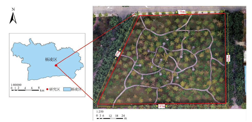
Fig.1
Sketch map in the study area
Tab.2
Statistics of measured single tree parameters
| 变量 | 最小值 | 最大值 | 平均值 |
|---|---|---|---|
| 树高/m | 7.5 | 14.9 | 11.5 |
| 冠幅/m | 4.0 | 9.0 | 5.8 |
| 树冠面积/m2 | 1.9 | 34.6 | 12.8 |

Fig.2
Flow chart of UAV image preprocessing
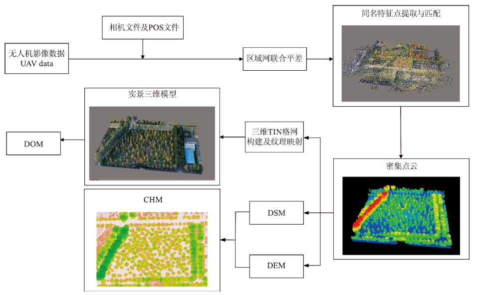
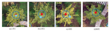
Fig.3
Classification of single tree top detection results

Tab.3
Accuracy assessment of tree top detection results
| 窗口大小/(m×m) | 样本数/株 | | | | r/% | p/% | F |
|---|---|---|---|---|---|---|---|
| 3×3 | 184 | 142 | 0 | 42 | 77.17 | 100.00 | 87.12 |
| 5×5 | 184 | 141 | 3 | 35 | 80.11 | 97.92 | 88.13 |
| 7×7 | 184 | 124 | 19 | 32 | 79.49 | 86.71 | 82.94 |
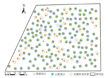
Fig.4
Vertex recognition results of single tree with 5m×5m window


Fig.5
Accuracy evaluation of single tree height extraction results
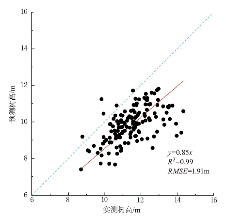

Fig.6
Single tree crown segmentation results
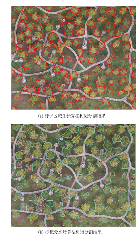
Fig.7
Influence of relative error threshold on extraction results
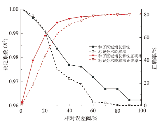
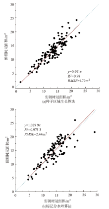
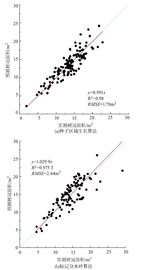
Fig.8
Accuracy evaluation of extraction results of tree crown area
| [1] | 李增元, 刘清旺, 庞勇. 激光雷达森林参数反演研究进展[J]. 遥感学报, 2016,20(5):1138-1150. |
| [2] |
Brieger F, Herzschuh U, Pestryakova L A, et al. Advances in the derivation of northeast Siberianforest metrics using high-resolution UAV-based photogrammetric point clouds[J]. Remote Sensing, 2019,11(12):1447.
doi: 10.3390/rs11121447 |
| [3] |
Jayathunga S, Owari T, Tsuyuki S. Evaluating the performance of photogrammetric products using fixed-wing UAV imagery over a mixed conifer-broadleaf forest:comparison with airborne laser scanning[J]. Remote Sensing, 2018,10(2):187.
doi: 10.3390/rs10020187 |
| [4] |
Thiel C, Schmullius C. Comparison of UAV photograph-based and airborne lidar-based point clouds over forest from a forestry application perspective[J]. International Journal of Remote Sensing, 2017,38(8-10):2411-2426.
doi: 10.1080/01431161.2016.1225181 |
| [5] | Mlambo R, Woodhouse I, Gerard F, et al. Structure from Motion(SfM)photogrammetry with drone data: alow cost method for monitoring greenhouse gas emissions from forests in developing countries[J]. Multidisciplinary Digital Publishing Institute, 2017,8(3):68. |
| [6] | 李涛, 冯仲科, 于东海, 等. 无人机摄影获取单木三维信息方法研究[J]. 中南林业科技大学学报, 2019,39(3):61-68. |
| [7] | 孙英伟, 林文树. 基于SFM算法的单木结构参数提取研究[J]. 西北林学院学报, 2020,35(5):180-184. |
| [8] |
Swetnam T L, Falk D A. Application of metabolic scaling theory to reduce error in local maxima tree segmentation from aerial LiDAR[J]. Forest Ecology and Management, 2014,323:158-167.
doi: 10.1016/j.foreco.2014.03.016 |
| [9] | 刘见礼, 张志玉, 倪文俭, 等. 无人机影像匹配点云单木识别算法[J]. 遥感信息, 2019,34(1):96-104. |
| [10] | 王雅佩, 王振锡, 李擎, 等. 基于无人机影像的天山云杉林伐后更新地林分密度估测研究[J]. 中南林业科技大学学报, 2020,40(5):57-66. |
| [11] |
Yang Jian, He Yuhong, Caspersen J P, et al. Delineating individual tree crowns in an uneven-aged,mixed broadleaf forest using multispectral watershed segmentation and multiscale fitting[J]. IEEE Journal of Selected Topics in Applied Earth Observations and Remote Sensing, 2016,10(4):1390-1401.
doi: 10.1109/JSTARS.4609443 |
| [12] |
Gaetano R, Masi G, Poggi G, et al. Marker-controlled watershed-based segmentation of multiresolution remote sensing images[J]. IEEE Transactions on Geoscience and Remote Sensing, 2014,53(6):2987-3004.
doi: 10.1109/TGRS.2014.2367129 |
| [13] |
Korpela I, Anttila P, Pitkänen J. The performance of a local maxima method for detecting individual tree tops in aerial photographs[J]. International Journal of Remote Sensing, 2006,27(6):1159-1175.
doi: 10.1080/01431160500354070 |
| [14] |
Mohan M, Silva C A, Klauberg C, et al. Individual tree detection from unmanned aerial vehicle(UAV)derived canopy height model in an open canopy mixed conifer forest[J]. Forests, 2017,8(9):340.
doi: 10.3390/f8090340 |
| [15] | 刘江俊, 高海力, 方陆明, 等. 基于无人机影像的树顶点和树高提取及其影响因素分析[J]. 林业资源管理, 2019(4):107-116. |
| [16] | 袁梓健, 舒清态, 赵洪莹, 等. 基于无人机可见光影像的华山松人工林计测参数提取[J]. 林业资源管理, 2021(2):110-116. |
| [17] | 陈崇成, 李旭, 黄洪宇. 基于无人机影像匹配点云的苗圃单木冠层三维分割[J]. 农业机械学报, 2018,49(2):149-155. |
| [18] | 杜意鸿, 尹田, 周雪梅, 等. 倾斜摄影测量技术提取油松单木信息[J]. 北京林业大学学报, 2021,43(4):77-86. |
| [19] | 李祥, 吴金卓, 林文树, 等. 一种高郁闭度林分树高的估测方法[J]. 测绘科学, 2019,44(7):128-134. |
| [20] |
Dalponte M, Coomes D A. Tree‐centric mapping of forest carbon density from airborne laser scanning and hyperspectral data[J]. Methods in Ecology and Evolution, 2016,7(10):1236-1245.
doi: 10.1111/2041-210X.12575 pmid: 28008347 |
| [21] |
Hirschmugl M, Ofner M, Raggam J, et al. Single tree detection in very high resolution remote sensing data[J]. Remote Sensing of Environment, 2007,110(4):533-544.
doi: 10.1016/j.rse.2007.02.029 |
| [22] | 李平昊, 申鑫, 代劲松, 等. 机载激光雷达人工林单木分割方法比较和精度分析[J]. 林业科学, 2018,54(12):127-136. |
| [23] | 杨全月, 董泽宇, 马振宇, 等. 基于SfM的针叶林无人机影像树冠分割算法[J]. 农业机械学报, 2020,51(6):181-190. |
| [24] |
Guerra-Hernández J, Cosenza D N, Rodriguez L C E, et al. Comparison of ALS-and UAV(SfM)-derived high-density point clouds for individual tree detection in Eucalyptus plantations[J]. International Journal of Remote Sensing, 2018,39(15-16):5211-5235.
doi: 10.1080/01431161.2018.1486519 |
| [25] |
Picos J, Bastos G, Míguez D, et al. Individual tree detection in a eucalyptus plantation using unmanned aerial vehicle(UAV)-LiDAR[J]. Remote Sensing, 2020,12(5):885.
doi: 10.3390/rs12050885 |
| [26] |
Xu Wenbing, Deng Susu, Liang Dan, et al. A crown morphology-based approach to individual tree detection in subtropical mixed broadleaf urban forests using UAV LiDAR data[J]. Remote Sensing, 2021,13(7):1278.
doi: 10.3390/rs13071278 |
| [27] | Abd Latif Z, Aman S N A, Ghazali R. Delineation of tree crown and canopy height using airborne LiDAR and aerial photo[C]. 2011 IEEE 7th International Colloquium on Signal Processing and its Applications, 2011:354-358. |
| [28] |
Chasmer L, Hopkinson C, Treitz P. Investigating laser pulse penetration through a conifer canopy by integrating airborne and terrestrial lidar[J]. Canadian Journal of Remote Sensing, 2006,32(2):116-125.
doi: 10.5589/m06-011 |
| [29] | Chen Qi, Baldocchi D, Gong Peng, et al. Isolating individual trees in a savanna woodland using small footprint lidar data[J]. Photogrammetric Engineering & Remote Sensing, 2006,72(8):923-932. |
| [30] |
Zhao Kaiguang, Popescu S, Nelson R. Lidar remote sensing of forest biomass:A scale-invariant estimation approach using airborne lasers[J]. Remote Sensing of Environment, 2009,113(1):182-196.
doi: 10.1016/j.rse.2008.09.009 |
| [31] |
Ma Zhenyu, Pang Yong, Wang Di, et al. Individual tree crown segmentation of a larch plantation using airborne laser scanning data based on region growing and canopy morphology features[J]. Remote Sensing, 2020,12(7):1078.
doi: 10.3390/rs12071078 |
| [1] | ZHOU Xiangbei, LI Chungan, YU Zhu, CHEN Zhongchao, SU Kai. Classification of Vertical Forest Structure of Overstory in Subtropical Forests Using Airborne Lidar Data [J]. FOREST RESOURCES WANAGEMENT, 2022, 0(1): 106-113. |
| [2] | FU Anmin, GAO Xianlian, WU Fayun, GAO Jinping. A Method to Validate Airborne LIDAR CHM Producton Individual Tree Level [J]. FOREST RESOURCES WANAGEMENT, 2022, 0(1): 114-123. |
| [3] | ZHOU Chenqin, YU Yongjun, FANG Luming, LIU Yuzhen, HU Jianjin. Effects of Flight Height and Canopy Density on Canopy Extraction of Metasequoia glyptostroboides [J]. FOREST RESOURCES WANAGEMENT, 2022, 0(1): 150-156. |
| [4] | YE Peng, TANG Mengping. Analysis of Canopy Density and Crown Overlap of Evergreen Broad-Leaved Forest Based on GIS [J]. FOREST RESOURCES WANAGEMENT, 2021, 0(5): 70-79. |
| [5] | LIU Yingchun, WU Fayun, SUN Zhongqiu, FU Anmin, GAO Jinping, GAO Xianlian, GAO Jianxin, CUI Chenyan, CHAO Zhi. Comprehensive Experiment Substitute for Multi-Payload Data of Terrestrial Ecosystem Carbon Inventory Satellite in Hainan [J]. FOREST RESOURCES WANAGEMENT, 2021, 0(4): 138-148. |
| [6] | ZHANG Yanyan, WANG Qunxing, LUO Yusheng, LV Kangting, MA Ruiting, YAN Dongfeng. Effect of Forest Thinning on the Light Environmentof Quercus Variabilis Plantation and its Target Trees [J]. FOREST RESOURCES WANAGEMENT, 2021, 0(4): 79-85. |
| [7] | SUN Yujiang, LI Fengtao, CHEN Xiangqin, ZHANG Lei, YANG Ning, ZHENG Da. Application of UAV Aerial Photo Data in Forest Information Extraction [J]. FOREST RESOURCES WANAGEMENT, 2021, 0(3): 160-164. |
| [8] | PU Ying, ZENG Weisheng, YANG Fan. Tree Height-Diameter Regression Models Development and One-Variable Tree Volume Tables Examination in Beijing [J]. FOREST RESOURCES WANAGEMENT, 2021, 0(3): 62-66. |
| [9] | WU Fayun, GAO Xianlian, ZHOU Rong, WANG Pengjie, FU Anmin. Research on Forest Biomass and Stock Volume Model Based on Stand Height and Canopy Density [J]. FOREST RESOURCES WANAGEMENT, 2021, 0(2): 61-67. |
| [10] | BAI Mingxiong, ZHANG Chao, CHEN Qi, WANG Juan, LI Huayu, SHI Xiaorong, TIAN Xianyun, ZHANG Yuwei. Study on the Extraction of Individual Tree Height Based on UAV Visual Spectrum Remote Sensing [J]. FOREST RESOURCES WANAGEMENT, 2021, 0(1): 164-172. |
| [11] | WU Simin, SUN Hua, LIN Hui. Research on LiDAR Stand Average High Inversion Method Based on Auto-adaptive Threshold and Peak Value [J]. FOREST RESOURCES WANAGEMENT, 2021, 0(1): 61-68. |
| [12] | LUO Kaijian, XV Xiaodong, LONG Jiangping, XV Congrong, LIN Hui, HE Xiaofeng. Research on Estimation of Coniferous Forest Volume in Longnan County Based on Landsat 8 and PALSAR-2 Images [J]. FOREST RESOURCES WANAGEMENT, 2021, 0(1): 69-76. |
| [13] | PU Yihan, XU Dandan, WANG Haobin. An Approach on Estimating Canopy Closure via Digital Images [J]. FOREST RESOURCES WANAGEMENT, 2020, 0(6): 153-160. |
| [14] | SUN Zhongqiu, WU Fayun, GAO Xianlian, GAO Jinping, HU Yang. Estimation of Forest Canopy Height Based on Large-Footprint Airborne LiDAR Data [J]. FOREST RESOURCES WANAGEMENT, 2020, 0(3): 111-117. |
| [15] | LIN Lili, HAO Zhenbang, YANG Liuqing, GAO Yangchi, LIU Yanfen, YU Kunyong, LIU Jian. The Development and Application of Automatic Measurement System for Forest Canopy Closure [J]. FOREST RESOURCES WANAGEMENT, 2020, 0(2): 167-172. |
| Viewed | ||||||
|
Full text |
|
|||||
|
Abstract |
|
|||||