

Forest and Grassland Resources Research ›› 2024›› Issue (1): 56-64.doi: 10.13466/j.cnki.lczyyj.2024.01.008
• Scientific Research • Previous Articles Next Articles
TANG Jiajun( ), CHAI Zongzheng()
Received:2023-10-17
Revised:2023-12-09
Online:2024-02-28
Published:2024-03-22
CLC Number:
TANG Jiajun, CHAI Zongzheng. Remote Sensing Estimation of Average Diameter at Breast Height of Forest Stands Based on Airborne LiDAR and Machine Learning Algorithms[J]. Forest and Grassland Resources Research, 2024, (1): 56-64.
Add to citation manager EndNote|Ris|BibTeX
URL: http://www.lyzygl.com.cn/EN/10.13466/j.cnki.lczyyj.2024.01.008
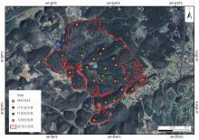
Fig.1
Geographical Location and sample plot distribution of the study area

Tab.1
Overview of sample plot
| 森林类型 | 样地数量/个 | 平均胸径/cm | 平均树高/m | 林分蓄积/m3 |
|---|---|---|---|---|
| 柳杉(Cryptomeria japonica)纯林 | 3 | 20.05 | 15.05 | 56.02 |
| 针叶混交林 | 7 | 19.84 | 14.35 | 106.03 |
| 针阔混交林 | 17 | 21.88 | 16.43 | 323.13 |
| 马尾松(Pinus massoniana)纯林 | 21 | 26.38 | 17.70 | 486.97 |
Tab.2
Characteristic variables screened through square difference expansion factor analysis
| 变量类别 | 变量名称 | 变量描述 | 变量 |
|---|---|---|---|
| 高度特征变量 | 1%分位数累计高度 | 激光返回点云1%的点所在累计高度 | HA1 |
| 高度中位数 | 所有点高度值的中位数 | Hm | |
| 高度峰度 | 所有点高度值的平坦程度 | Hk | |
| 高度偏态 | 所有点高度分布的对称程度 | HS | |
| 冠层特征变量 | 平均冠层高度 | 大于高度阈值的所有点高度平均值,指树冠平均高度 | ImCH |
| 冠层高度标准差 | 林分冠层高度的标准差 | IsdCH | |
| 郁闭度 | 冠层垂直投影占林地面积百分比 | ICC | |
| 叶面积指数 | 叶片表面积的一半 | ILAI |
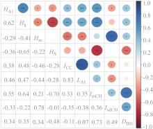
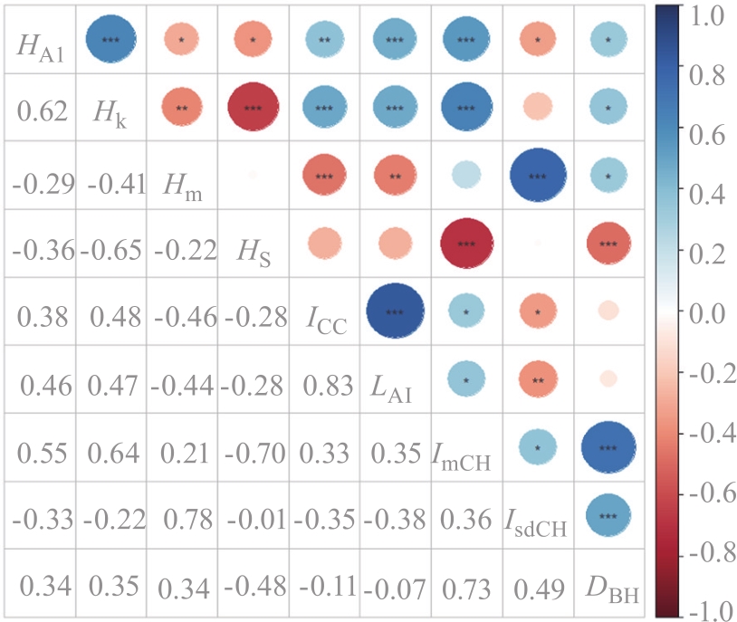
Fig.2
Correlation analysis between point cloud characteristic variables and average diameter at breast height of forest stands
Tab.3
Important values of various influencing factors in random forests
| 变量 | 重要值/% | 排序 |
|---|---|---|
| ImCH | 60.94 | 1 |
| IsdCH | 12.68 | 2 |
| HA1 | 8.90 | 3 |
| Hk | 7.12 | 4 |
| Hm | 5.48 | 5 |
| HS | 4.88 | 6 |
Tab.4
Accuracy evaluation of support vector machines with different kernel functions
| 核函数类型 | 决定系数(R2) | 均方根误差(RMSE)/cm |
|---|---|---|
| 线性内核 | 0.66 | 2.48 |
| 多项式内核 | 0.66 | 2.49 |
| 径向基内核 | 0.67 | 2.32 |
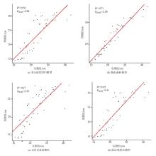
Fig.3
The relationship between predicted values and measured values of four models
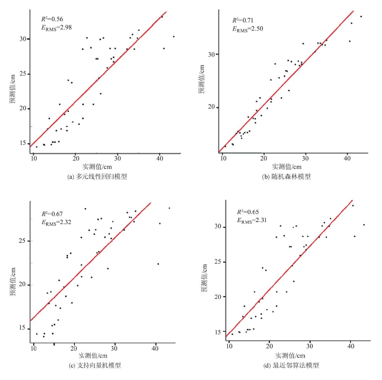
Tab.5
Fitting effects of different models
| 模型类型 | 决定系数(R2) | 均方根误差(RMSE)/cm | ||
|---|---|---|---|---|
| 多元线性回归(MLR) | 0.56 | 2.98 | ||
| 随机森林(RF) | 0.71 | 2.50 | ||
| 支持向量机(SVM) | 0.67 | 2.32 | ||
| 最近邻算法(KNN) | 0.65 | 2.31 | ||
Tab.6
Fitting results of different forest type models
| 森林类型 | 样地数量/个 | 实测值/cm | MLR | RF | SVM | KNN | |||||||
|---|---|---|---|---|---|---|---|---|---|---|---|---|---|
| 预测值/cm | 差值/cm | 预测值/cm | 差值/cm | 预测值/cm | 差值/cm | 预测值/cm | 差值/cm | ||||||
| 柳杉纯林 | 3 | 20.05 | 19.47 | -0.58 | 20.13 | 0.08 | 19.54 | -0.51 | 19.59 | -0.46 | |||
| 针叶混交林 | 7 | 19.84 | 20.80 | 0.96 | 19.83 | -0.01 | 20.30 | 0.46 | 20.10 | 0.26 | |||
| 针阔混交林 | 17 | 21.88 | 23.31 | 1.43 | 22.70 | 0.82 | 22.53 | 0.65 | 23.21 | 1.33 | |||
| 马尾松纯林 | 21 | 26.38 | 24.26 | -2.12 | 25.56 | -0.82 | 23.87 | -2.51 | 24.74 | -1.64 | |||
| [1] | 李海奎, 法蕾. 基于分级的全国主要树种树高-胸径曲线模型[J]. 林业科学, 2011, 47(10):83-90. |
| [2] |
Andersen H, McGaughey R J, Reutebuch S E. Estimating forest canopy fuel parameters using LIDAR data[J]. Remote Sensing of Environment, 2005, 94(4):441-449.
doi: 10.1016/j.rse.2004.10.013 |
| [3] |
Balduzzi M A, Zande D V, Stuckens J, et al. The properties of terrestrial laser system intensity for measuring leaf geometries:A case study with conference pear trees(Pyrus Communis)[J]. Sensors, 2011, 11(2):1657-1681.
doi: 10.3390/s110201657 |
| [4] | 李增元, 陈尔学. 中国林业遥感发展历程[J]. 遥感学报, 2021, 25(1):292-301. |
| [5] | 韦雪花. 轻小型航空遥感森林几何参数提取研究[D]. 北京: 北京林业大学, 2013. |
| [6] |
吕金城, 王振锡, 杨勇强, 等. 基于无人机影像的天山云杉林树高提取及蓄积量的反演[J]. 新疆农业科学, 2021, 58(10):1838-1845.
doi: 10.6048/j.issn.1001-4330.2021.10.009 |
| [7] |
Swayze N C, Tinkham W T. Application of unmanned aerial system structure from motion point cloud detected tree heights and stem diameters to model missing stem diameters[J]. MethodsX, 2022, 9:101729.
doi: 10.1016/j.mex.2022.101729 |
| [8] |
Mao Zhihui, Lu Zhuo, Wu Yanjie, et al. DBH estimation for indivi-dual tree:Two-dimensional images or three-dimensional point clouds?[J]. Remote Sensing, 2023, 15(16):4116.
doi: 10.3390/rs15164116 |
| [9] |
Lefsky M A, Cohen W B, Acker S A, et al. Lidar remote sensing of the canopy structure and biophysical properties of Douglas-fir western hemlock forests[J]. Remote Sensing of Environment, 1999, 70(3):339-361.
doi: 10.1016/S0034-4257(99)00052-8 |
| [10] | Hawbaker T J, Gobakken T, Lesak A, et al. Light detection and ranging-based measures of mixed hardwood forest structure[J]. Forest Science, 2010, 56(3):313-326. |
| [11] |
Zhang Zhengnan, Wang Tiejun, Skidmore A K, et al. An improved area-based approach for estimating plot-level tree DBH from airborne LiDAR data[J]. Forest Ecosystems, 2023, 10:100089.
doi: 10.1016/j.fecs.2023.100089 |
| [12] |
Zhao Xiaoqian, Guo Qinghua, Su Yanjun, et al. Improved progressive TIN densification filtering algorithm for airborne LiDAR data in forested areas[J]. ISPRS Journal of Photogrammetry and Remote Sensing, 2016, 117:79-91.
doi: 10.1016/j.isprsjprs.2016.03.016 |
| [13] |
Næsset E, Gobakken T. Estimation of above-and below-ground biomass across regions of the boreal forest zone using airborne laser[J]. Remote Sensing of Environment, 2008, 112(6):3079-3090.
doi: 10.1016/j.rse.2008.03.004 |
| [14] |
Zhang Zhengnan, Cao Lin, Mulverhill C, et al. Prediction of diameter distributions with multimodal models using LiDAR data in subtropical planted forests[J]. Forests, 2019, 10(2):125.
doi: 10.3390/f10020125 |
| [15] | 庞勇, 李增元. 基于机载激光雷达的小兴安岭温带森林组分生物量反演[J]. 植物生态学报, 2012, 36(10):1095-1105. |
| [16] | 常晓敏. 华北北部防护林主要树种立地-生长-结构-功能多元耦合关系研究[D]. 北京: 北京林业大学, 2021. |
| [17] |
Belgiu M, Drăguţ L. Random forest in remote sensing:A review of applications and future directions[J]. ISPRS Journal of Photogrammetry and Remote Sensing, 2016, 114:24-31.
doi: 10.1016/j.isprsjprs.2016.01.011 |
| [18] | 林卓, 吴承祯, 洪伟, 等. 基于BP神经网络和支持向量机的杉木人工林收获模型研究[J]. 北京林业大学学报, 2015, 37(1):42-47. |
| [19] | 曹庆先. 北部湾沿海红树林生物量和碳贮量的遥感估算[D]. 北京: 中国林业科学研究院, 2010. |
| [20] | 付逍遥. 基于机载和无人机点云数据的平原人工林结构参数动态监测[D]. 南京: 南京林业大学, 2021. |
| [21] | 黄昕晰. 基于无人机影像与Mask R-CNN的城市单木检测与参数提取研究[D]. 杭州: 浙江农林大学, 2020. |
| [22] | 张峥男. 杉木和桉树人工林胸径结构估测和采伐优先等级划分[D]. 南京: 南京林业大学, 2023. |
| [23] |
Tian Dongyuan, Jiang Lichun, Shahzad M K, et al. Climate-sensitive tree height-diameter models for mixed forests in Northeastern China[J]. Agricultural and Forest Meteorology, 2022, 326:109182.
doi: 10.1016/j.agrformet.2022.109182 |
| [24] |
Lines E R, Zavala M A, Purves D W, et al. Predictable changes in aboveground allometry of trees along gradients of temperature,aridity and competition[J]. Global Ecology and Biogeography, 2012, 21(10):1017-1028.
doi: 10.1111/geb.2012.21.issue-10 |
| [25] |
Hulshof C M, Swenson N G, Weiser M D. Tree height-diameter allometry across the United States[J]. Ecology and Evolution, 2015, 5(6):1193-1204.
doi: 10.1002/ece3.1328 pmid: 25859325 |
| [26] | 欧强新. 基于机器学习的吉林天然针阔混交林生长建模[D]. 北京: 中国林业科学研究院, 2019. |
| [27] | 朱兆廷, 孙玉军, 梁瑞婷, 等. 基于树冠和竞争因子的杉木胸径估测[J]. 北京林业大学学报, 2023, 45(9):42-51. |
| [28] | 陈玉玲. 人工林适地适树与生长收获效益评估研究[D]. 北京: 北京林业大学, 2020. |
| [29] |
Mensah S, Pienaar O L, Kunneke A, et al. Height-Diameter allometry in South Africa's indigenous high forests:Assessing generic models performance and function forms[J]. Forest Ecology and Management, 2018, 410:1-11.
doi: 10.1016/j.foreco.2017.12.030 |
| [30] |
Cysneiros V C, Pelissari A L, Gaui T D, et al. Modeling of tree height-diameter relationships in the Atlantic forest:Effect of forest type on tree allometry[J]. Canadian Journal of Forest Research, 2020, 50(12):1289-1298.
doi: 10.1139/cjfr-2020-0060 |
| [31] |
Mokroš M, Liang Xinlian, Surovy P, et al. Evaluation of close-range photogrammetry image collection methods for estimating tree diameters[J]. ISPRS International Journal of Geo-Information, 2018, 7(3):93.
doi: 10.3390/ijgi7030093 |
| [32] |
Chave J, Andalo C, Brown S, et al. Tree allometry and improved estimation of carbon stocks and balance in tropical forests[J]. Oecologia, 2005, 145:87-99.
doi: 10.1007/s00442-005-0100-x pmid: 15971085 |
| [1] | TANG Jiajun, WANG Gang, CHAI Zongzheng. Single-TreeVolume Estimation of Pinus massoniana based on Airborne LiDAR Point Cloud [J]. Forest and Grassland Resources Research, 2023, 0(6): 105-112. |
| [2] | ZHANG Guoli, CI Xuelun, YANG Xueqing, JIANG Chunying, SUN Zhichao, MENG Haiding. Study on Spatio-Temporal Distribution Characteristics and Susceptibility Analysis of Forest Fire [J]. Forest and Grassland Resources Research, 2023, 0(5): 48-55. |
| [3] | LIANG Licheng, FU Xiaoqiang, ZHANG Bin, CHENG Guxun, LI Zuohui. Dynamic Monitoring of Spartina alterniflora in Xiangshan Harbor Based on GEE and Random Forest [J]. FOREST RESOURCES WANAGEMENT, 2023, 0(3): 38-45. |
| [4] | WANG Xiaohui, ZHANG Huiru, PANG Yong, QIN Xianlin, LI Haikui, MENG Shili, YU Tao. Forest Vegetation Type Monitoring in the Natural Forest Protection Project Area [J]. FOREST RESOURCES WANAGEMENT, 2023, 0(2): 96-103. |
| [5] | GAO Jinping, YU Huina, ZHAI Zhaokun. Application of High Resolution Multi-Mode Satellite in Forest Land Types and Tree Species Identification [J]. FOREST RESOURCES WANAGEMENT, 2023, 0(1): 127-132. |
| [6] | ZHANG Xinjie, ZHENG Yanfeng, WEN Kunjian, WANG Pengjie, WU Fayun. Estimation of Single Tree Factor of Eucalyptus by Merging Airborne and Backpack LiDAR [J]. FOREST RESOURCES WANAGEMENT, 2022, 0(6): 131-137. |
| [7] | WANG Xiaoyang, JIANG Youyi, LI Xiao, HU Yaxuan, ZHANG Jiazheng, LIU Bowei. A Multi-Temporal and Multi-Feature Larch Plantation Extraction Study Based on GF-1 Images [J]. FOREST RESOURCES WANAGEMENT, 2022, 0(4): 109-118. |
| [8] | HUANG Bingqian, YUE Cairong, ZHU Bodong. Estimation of Forest Volume Based on Multi-Scale Remote Sensing Features of GF-1 [J]. FOREST RESOURCES WANAGEMENT, 2022, 0(3): 54-59. |
| [9] | HUANG Jincheng, LIU Hongsheng, NING Jinkui, OUYANG Xunzhi, ZANG Hao. Study of Adaptability of the Primary Afforestation Species in Chongyi County,Jiangxi Province Based on Random Forest [J]. FOREST RESOURCES WANAGEMENT, 2022, 0(2): 117-125. |
| [10] | LONG Zhihao, LUO Peng, XU Dengping, LI Zhen, DAI Huabin. Inversion Research of Forest Stock Volume Using the Red Edge Bands of Sentinel-2A [J]. FOREST RESOURCES WANAGEMENT, 2022, 0(2): 126-134. |
| [11] | FU Anmin, GAO Xianlian, WU Fayun, GAO Jinping. A Method to Validate Airborne LIDAR CHM Producton Individual Tree Level [J]. FOREST RESOURCES WANAGEMENT, 2022, 0(1): 114-123. |
| [12] | TANG Jinhao, ZHANG Jialong, CHEN Liye, CHENG Tao. Research on Estimation of Aboveground Biomass and Scale Conversion for Pinus densata Mast [J]. FOREST RESOURCES WANAGEMENT, 2021, 0(6): 83-89. |
| [13] | LONG Fei, YUE Cairong, JIN Jing, LI Chungan, LUO Hongbin, XU Wanting. Study on the Inversion of Basal Area from Airborne LiDAR Data [J]. FOREST RESOURCES WANAGEMENT, 2021, 0(5): 62-69. |
| [14] | DU Zhi, CHEN Zhenxiong, MA Kaisen, LIU Ziwei, GU Xinggui. Estimating Standing Volume in Southern Collective Forest Region Based on the Unmanned Aerial Vehicle LiDAR Characteristic Variables [J]. FOREST RESOURCES WANAGEMENT, 2021, 0(4): 157-165. |
| [15] | XIAO Yue, XU Xiaodong, LONG Jiangping, LIN Hui. Research on Inversion of Forest Volume Based on Domestic High-Resolution Data [J]. FOREST RESOURCES WANAGEMENT, 2021, 0(3): 101-107. |
| Viewed | ||||||
|
Full text |
|
|||||
|
Abstract |
|
|||||