欢迎访问林业资源管理

林业资源管理 ›› 2017, Vol. 0 ›› Issue (1): 37-42.doi: 10.13466/j.cnki.lyzygl.2017.01.008

• 科学研究 • 上一篇    下一篇

基于林业与国土一张图的林地数据协同处理实证研究

陶吉兴1(), 徐达1, 戴韫卓2, 季碧勇1, 张国江1, 张小伟1   

  1. 1. 浙江省森林资源监测中心,杭州 310020
    2. 浙江省土地勘测规划院,杭州 310027
  • 收稿日期:2016-10-31 修回日期:2016-12-22 出版日期:2017-02-28 发布日期:2020-10-03
  • 作者简介:陶吉兴(1963-),浙江绍兴人,教授级高工,硕士,主要从事森林资源调查监测和评估研究。Email: 42468122@qq.com
  • 基金资助:
    国家重点研发计划课题(2016YFC0502704)

The Empirical Research on Coordinative Processing of Forest Land Data in One Map of Forestry and Land

TAO Jixing1(), XU Da1, DAI Yunzhuo2, ZHANG Guojiang1, JI Biyong1, ZHANG Xiaowei1   

  1. 1. Center for Forest Resource Monitoring of Zhejiang Province,Hangzhou 310020,Zhejiang,China
    2. Institute of Land Surveying and Planning of Zhejiang Province,Hangzhou 310027,China
  • Received:2016-10-31 Revised:2016-12-22 Online:2017-02-28 Published:2020-10-03

摘要:

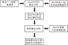
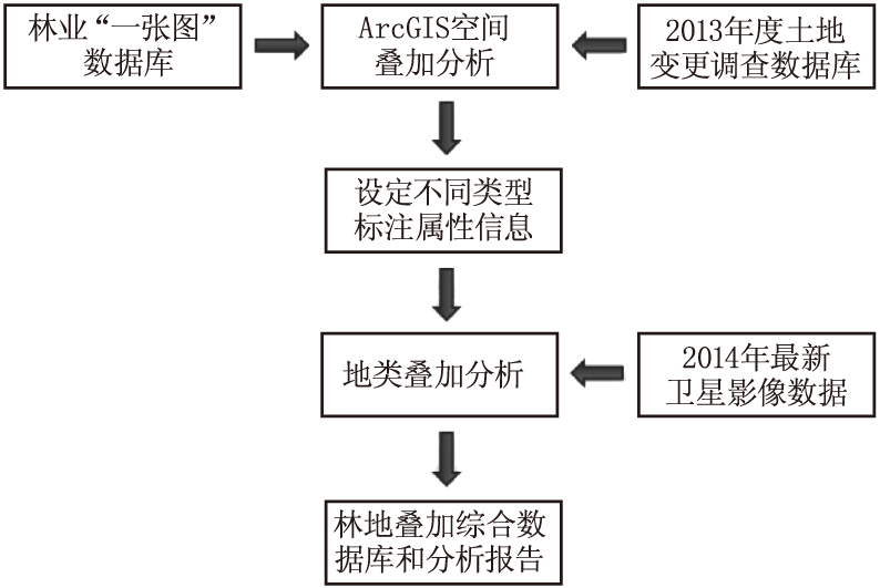
借助GIS,在对林业与国土一张图做空间叠加分析的基础上,有效衔接两部门一张图中每个斑块的林地管理类型。以林业部门管理的林地基础属性为主线,充分考虑与国土部门认定的林地范围对接,把林地管理类型分为:双方共同认定林地、林业单方认定林地、农用地、未利用地上林地和建设用地上林地。研究结果表明:山区县双方共同认定林地范围差异最小,丘陵县次之,平原盆地县差异最大;山区林业单方认定林地面积占比小,平原区占比大;平原区农用地与未利用地上的林地相对普遍存在,丘陵、山区相对较少;建设用地上的林地面积比例与各地的城镇绿化水平高度相关,一般也是平原区高于山区。

关键词: 一张图, 林地管理类型, 协同处理, 空间叠加分析

Abstract:

Based on spatial overlay analysis to one map of forestry and land with the aid of GIS,forest management types in each plaque are effectively connected in one map of the two departments.With the concept of forest basic management attributes of the forestry department,butt-jointing of the range of forest land identified by the land department is taken into full account and forest management types are divided into forest land jointly determined by the both sides,forest land unilaterally determined by the forestry department,forest land on agricultural and unused land,forest land on construction land.The results showed that there is a smaller difference of forest land range jointly determined by the both sides in the mountainous county,the hilly county comes second,the plain and basin county has the biggest difference.The mountainous county has the smaller proportion in area and the plain county has the greater proportion in area in forest land unilaterally determined by the forestry department.There is the more forest land on agricultural and unused land in the plain county and the less forest land on agricultural and unused land in the hilly and mountainous counties.The truth is that the proportion of forest land area on construction land is highly relevant to greening level of local urban area.Generally,there is more forest land on construction land in plains and less forest land on construction land in mountainous area.

Key words: one map, management type of forest land, coordinative processing, spatial overlay analysis

中图分类号: