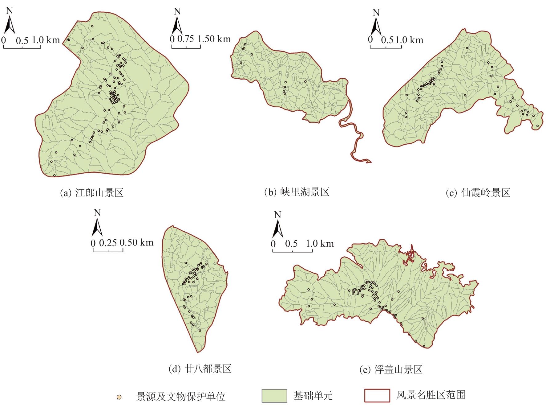
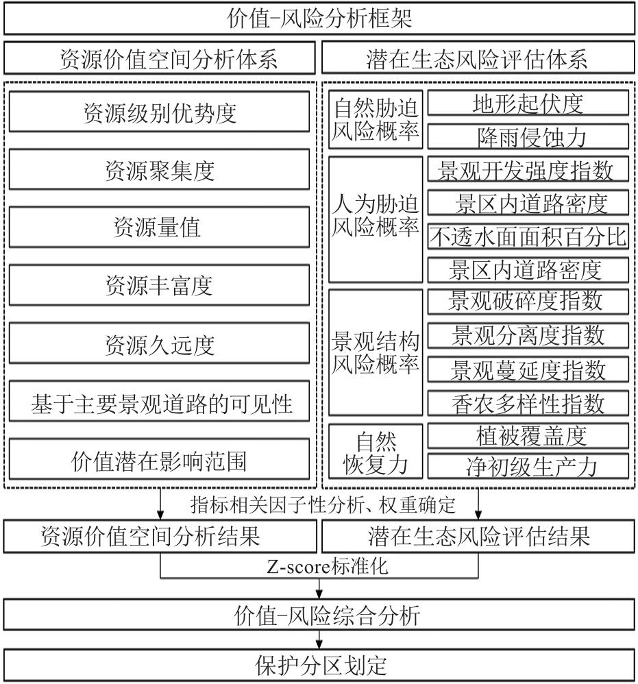
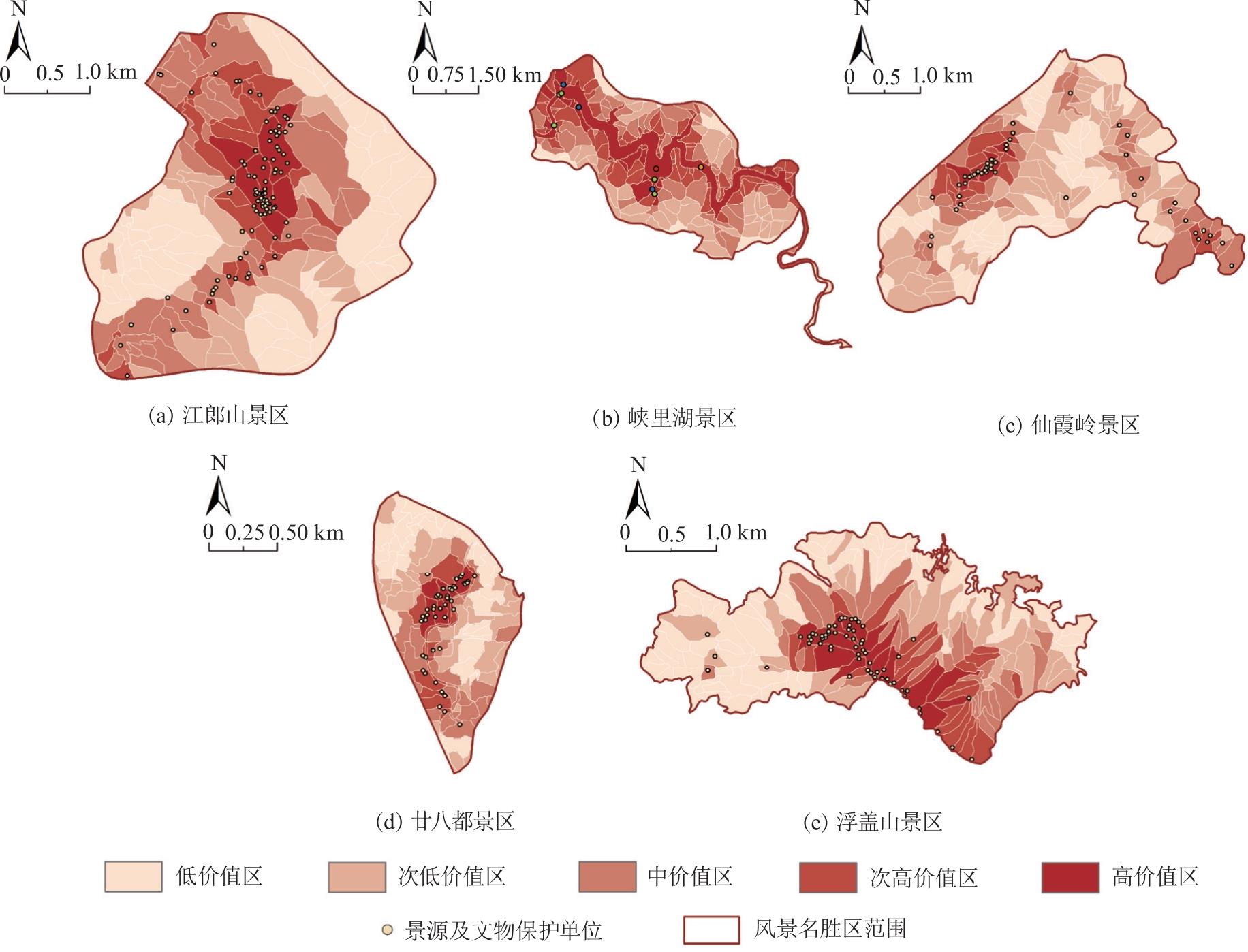
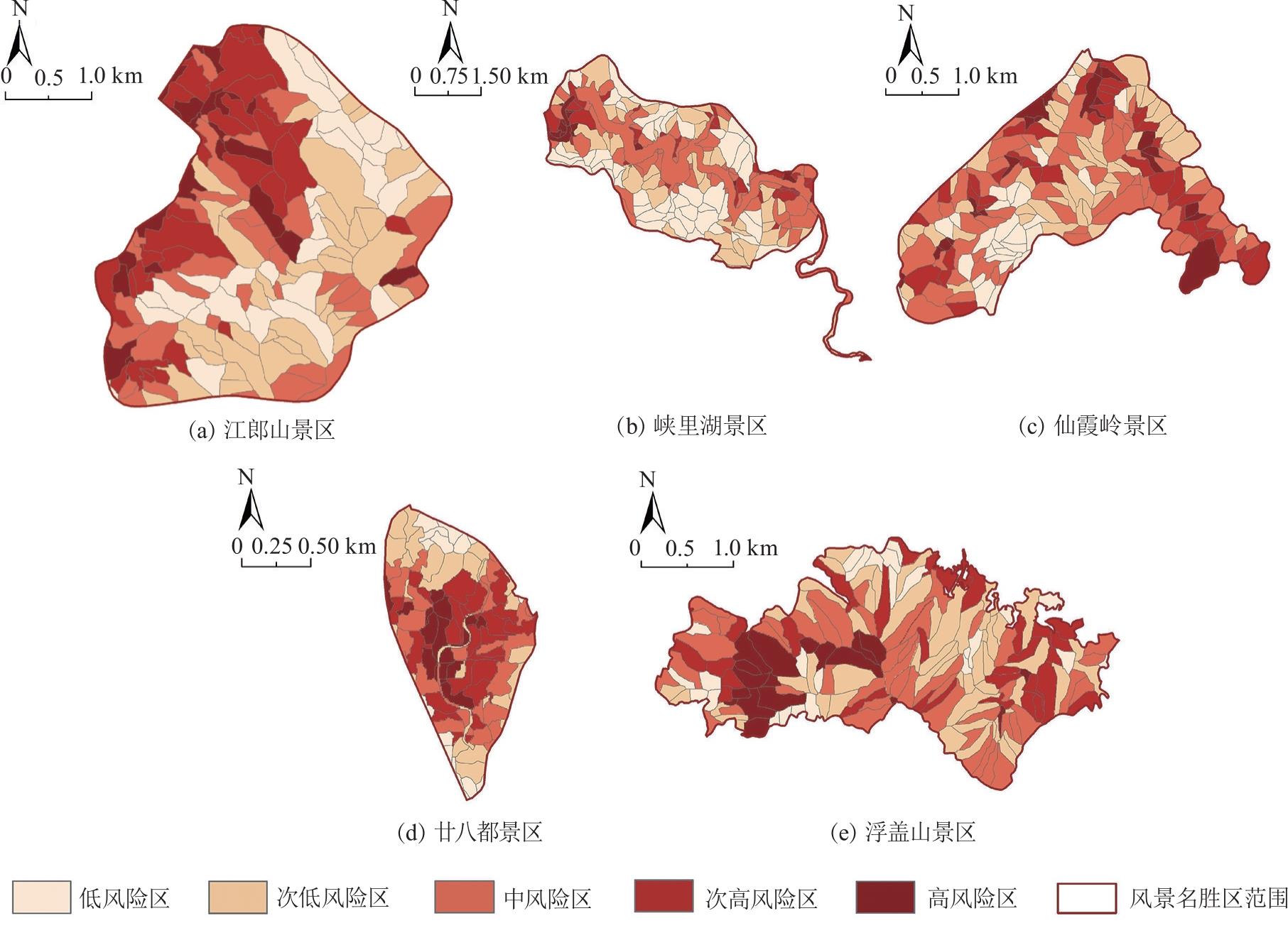
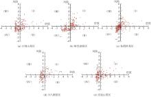
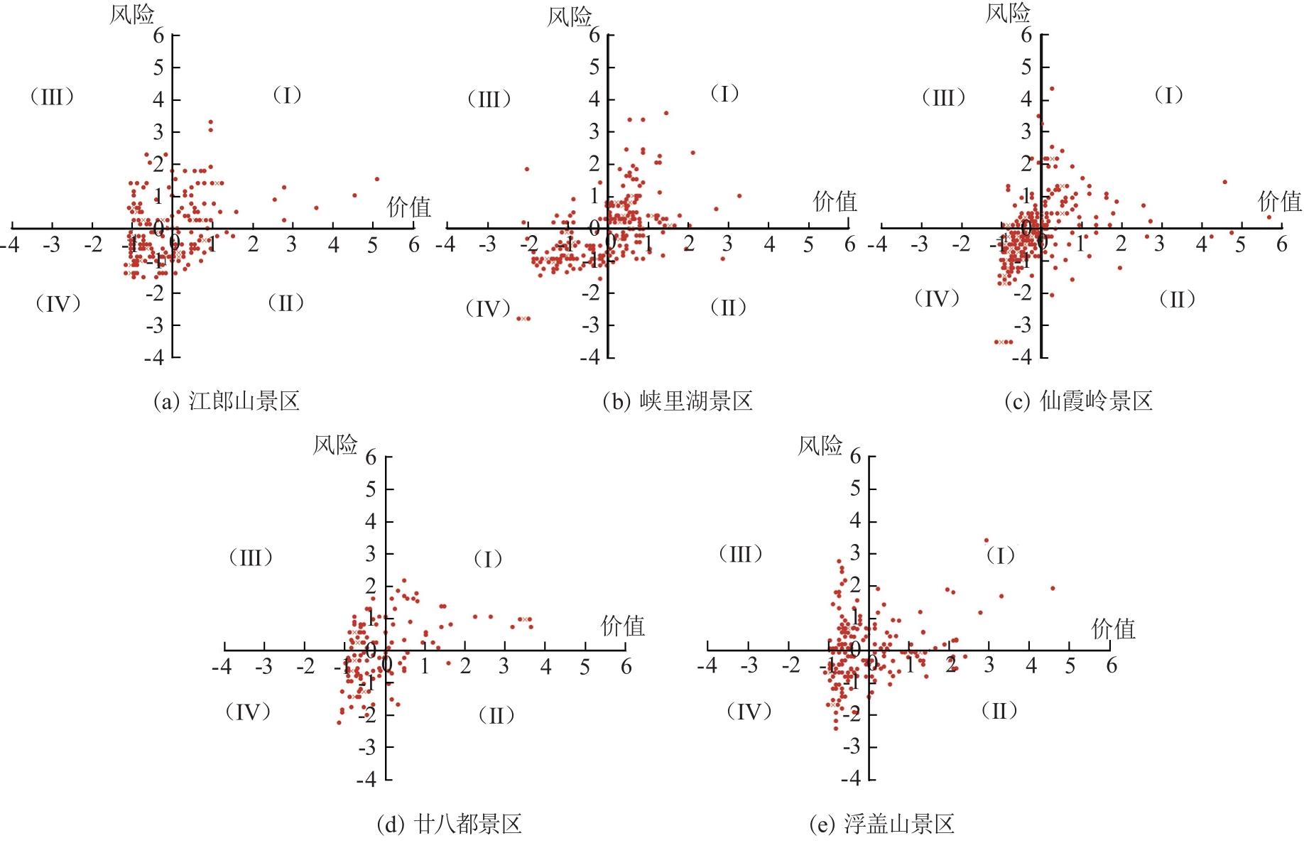
| [1] |
陈楚文, 王庆, 凌雨凡, 等. 浙江省风景名胜区人文景源分布特征及影响因素研究[J]. 中国园林, 2024, 40(2):17-23.
|
| [2] |
邓武功, 贾建中, 束晨阳, 等. 从历史中走来的风景名胜区:自然保护地体系构建下的风景名胜区定位研究[J]. 中国园林, 2019, 35(3):9-15.
|
| [3] |
朱江, 邓武功, 于涵, 等. 风景名胜区时空关系演变分析[J]. 中国园林, 2021, 37(3):118-123.
|
| [4] |
严国泰, 宋霖. 国家公园体制下风景名胜区的价值与发展路径[J]. 中国园林, 2021, 37(3):112-117.
|
| [5] |
杜文武, 胡瑶, 眭淼, 等. 金佛山国家级风景名胜区人类活动强度与景观格局时空变化响应研究[J]. 园林, 2022, 39(12):28-37.
|
| [6] |
王晓洁, 宋霖, 周宏俊. 基于边界效应理论的风景名胜区分区管控探讨[J]. 规划师, 2020, 36(20):32-36.
|
| [7] |
吴必虎, 谢冶凤, 李奕, 等. 生态保护红线战略视域下自然保护地如何划界和分区管控?[J]. 生物多样性, 2022, 30(4):21-26.
|
| [8] |
翟林, 辛蔚, 孙兴文, 等. 基于相关法规及标准的中国自然公园规划分区与管控分析[J]. 自然保护地, 2022, 2(3):65-74.
|
| [9] |
王国玉, 白伟岚. 风景名胜区生态敏感性评价研究与实践进展[J]. 中国园林, 2019, 35(2):87-91.
|
| [10] |
朱霞, 郑越. 山岳型风景名胜区生态敏感性评价及保护对策研究:以武汉市木兰山风景名胜区规划为例[J]. 华中建筑, 2021, 39(2):80-85.
|
| [11] |
张德顺, 杨韬. 应对生态保育规划的风景名胜区生态资源敏感性分析:基于生态资源评价结果[J]. 中国园林, 2018, 34(2):84-88.
|
| [12] |
马冰然, 曾维华, 解钰茜. 自然公园功能分区方法研究:以黄山风景名胜区为例[J]. 生态学报, 2019, 39(22):8286-8298.
|
| [13] |
张同升. 中国自然保护地有效管理的思考[J]. 中国土地, 2019(8):14-16.
|
| [14] |
贾建中. 风景名胜区功能定位与国家保护地体系[J]. 中国园林, 2020, 36(11):2-3.
|
| [15] |
LI Weijie, KANG Jinwen, WANG Yong. Integrating ecosystem services supply-demand balance into landscape ecological risk and its driving forces assessment in Southwest China[J]. Journal of Cleaner Production, 2024,475:143671.
|
| [16] |
曹祺文, 张曦文, 马洪坤, 等. 景观生态风险研究进展及基于生态系统服务的评价框架:ESRISK[J]. 地理学报, 2018, 73(5):843-855.
doi: 10.11821/dlxb201805005
|
| [17] |
刘晓, 屠颖星, 刘玉超. 国土空间规划体系下风景名胜区土地利用和管控优化路径:以庐山风景名胜区为例[J]. 规划师, 2023, 39(1):83-90.
|
| [18] |
吴隽宇, 朱榴奕. 生态系统环境-文化服务耦合视角下的珠江河口区生态功能分区[J]. 风景园林, 2023, 30(1):85-93.
|
| [19] |
金爱博, 张诗阳, 王向荣. 浙江省文化遗产时空格局及其与自然环境的关联研究:以文物保护单位为例[J]. 中国园林, 2022, 38(9):22-28.
|
| [20] |
李孜沫. 汾河流域古村落的时空演化与形成机理[J]. 经济地理, 2019, 39(2):207-214.
doi: 10.15957/j.cnki.jjdl.2019.02.025
|
| [21] |
李威, 罗军华, 苏维词, 等. 武陵山区旅游资源空间格局及生态旅游适宜性:以铜仁市域为例[J]. 科学技术与工程, 2022, 22(15):6180-6190.
|
| [22] |
住房城乡建设部. 风景名胜区总体规划标准:GB/T 50298—2018[S]. 北京: 中国建筑工业出版社, 2018.
|
| [23] |
RICHARDS D R, TUNÇER B. Using image recognition to automate assessment of cultural ecosystem services from social media photographs[J]. Ecosystem services, 2018,31:318-325.
|
| [24] |
HE Shan, SU Yue, SHAHTAHMASSEBI A R, et al. Assessing and mapping cultural ecosystem services supply,demand and flow of farmlands in the Hangzhou metropolitan area,China[J]. Science of the Total Environment, 2019,692:756-768.
|
| [25] |
李林汝, 员学锋, 张瑞娜, 等. 基于最大熵模型的生态系统文化服务空间分异及其对环境要素的响应分析:以陕北榆林市为例[J]. 生态学报, 2024, 44(21):9582-9595.
|
| [26] |
田毓仁, 刘成东, 严兆彬, 等. 浙江省江山市江郎山地质遗迹资源特征及成景机制探讨[J]. 地球学报, 2010, 31(4):585-592.
|
| [27] |
张传华, 王钟书, 张凤太, 等. 基于“重要性—脆弱性”分析框架的国土空间生态保护修复分区研究[J]. 地理与地理信息科学, 2022, 38(6):84-94.
|
| [28] |
王雪雯, 董晓华, 马耀明, 等. 长江中下游降雨侵蚀力时空变化及其与植被覆盖的关系[J]. 生态学报, 2024, 44(20):9364-9378.
|
| [29] |
刘世梁, 刘芦萌, 武雪, 等. 区域生态效应研究中人类活动强度定量化评价[J]. 生态学报, 2018, 38(19):6797-6809.
|
| [30] |
杨朝辉, 苏群, 陈志辉, 等. 基于LDI的土地利用类型与湿地水质的相关性:以苏州太湖三山岛国家湿地公园为例[J]. 环境科学, 2017, 38(1):104-112.
|
| [31] |
聂艳, 李怡敏, 李鑫, 等. 耦合风险概率与生态损失的襄十随神区域生态风险评价研究[J]. 长江流域资源与环境, 2024, 33(4):870-881.
|
| [32] |
邹珮雯, 徐昉. 生态安全格局构建及景观生态风险预测:以赛罕乌拉国家级自然保护区为例[J]. 生态学报, 2023, 43(23):9981-9993.
|
| [33] |
黄晓杰, 丁金华, 汪大庆. 苏南水网地区绿色空间景观生态风险时空演变与调控策略[J]. 浙江农林大学学报, 2024, 41(6):1283-1292.
|
| [34] |
金梦婷, 徐丽萍, 徐权. 基于FLUS-Markov模型的多情景景观生态风险评价与预测:以南疆克州为例[J]. 干旱区研究, 2021, 38(6):1793-1804.
doi: 10.13866/j.azr.2021.06.31
|
| [35] |
谢丽霞, 白永平, 车磊, 等. 基于价值—风险的黄河上游生态功能区生态分区建设[J]. 自然资源学报, 2021, 36(1):196-207.
doi: 10.31497/zrzyxb.20210113
|
| [36] |
王子芝, 李玥, 华世明, 等. 基于生态保护加权的普达措国家公园功能分区研究[J]. 南京林业大学学报(自然科学版), 2021, 45(6):225-231.
doi: 10.12302/j.issn.1000-2006.202012053
|
 ), 陈楚文1,2(