

FOREST RESOURCES WANAGEMENT ›› 2021, Vol. 0 ›› Issue (1): 50-60.doi: 10.13466/j.cnki.lyzygl.2021.01.008
• Scientific Research • Previous Articles Next Articles
XV Changjian1,2( ), LIU Yingchun1(), ZUO Lijun3, LI Jiangeng2, ZHANG Ting2, HAN Lumeng2, FANG Yu2, ZHANG Yin2, WANG Tian2
Received:2020-11-09
Revised:2020-12-12
Online:2021-02-28
Published:2021-03-30
Contact:
LIU Yingchun
E-mail:changjian.xu@qq.com;liuyingchun2005@163.com
CLC Number:
XV Changjian, LIU Yingchun, ZUO Lijun, LI Jiangeng, ZHANG Ting, HAN Lumeng, FANG Yu, ZHANG Yin, WANG Tian. Estimation on Forest Above-Ground Biomass Based on Simulated Large-Footprint LiDAR and Multi-Layer Perceptron[J]. FOREST RESOURCES WANAGEMENT, 2021, 0(1): 50-60.
Add to citation manager EndNote|Ris|BibTeX
URL: http://www.lyzygl.com.cn/EN/10.13466/j.cnki.lyzygl.2021.01.008
Tab.1
Flight parameters
| 参数名称 | 参数数值 |
|---|---|
| 激光发射频率/(kHz) | 400 |
| 飞行速度/(km/h) | 20 |
| 平均绝对航高/m | 1650 |
| 高程/m | 1500 |
| 相对航高/m | 150 |
| 航线间距/m | 260 |
| 旁向重叠度/% | 50 |
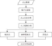
Fig.1
Point cloud classification process
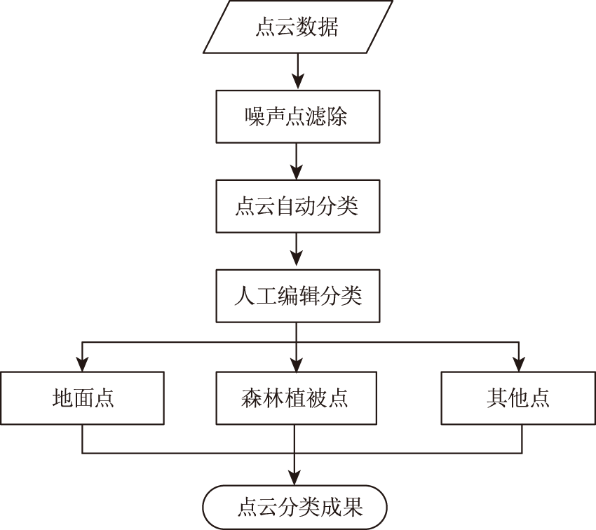
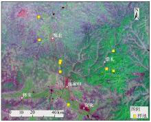
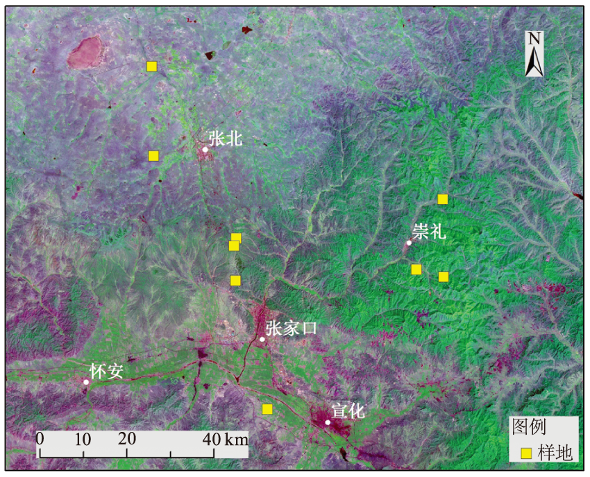
Fig.2
Study region and spatial distribution of field samples
Tab.2
Allometric equation of biomass of main tree species
| 树种 | 异速生长方程 | 参考文献 |
|---|---|---|
| 落叶松(L.gmelinii) | [14] | |
| 油松(P.tabulaeformis) | [15] | |
| 杨树(Populus L.) | [16] | |
| 白桦(B.platyphylla Suk.) | [17] | |
| 山杨(P.davidiana) | [17] | |
| 蒙古栎(Q.mongolica) | [17] | |
| 樟子松(P.sylvestnis var.) | [18] |

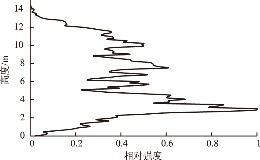
Fig.3
Normalized simulated large-footprint waveform
Tab.3
Definition of waveform parameters
| 参数 | 定义 |
|---|---|
| 由回波波形确定的第 | |
| 平均高,即波形起始位置到波形结束位置之间的高度加权均值 | |
| 最大高,即波形起始位置与波形结束位置之间的高度 | |
| 波形变异系数 | |
| 波形标准差 |

Fig.4
Structure diagram of MLP
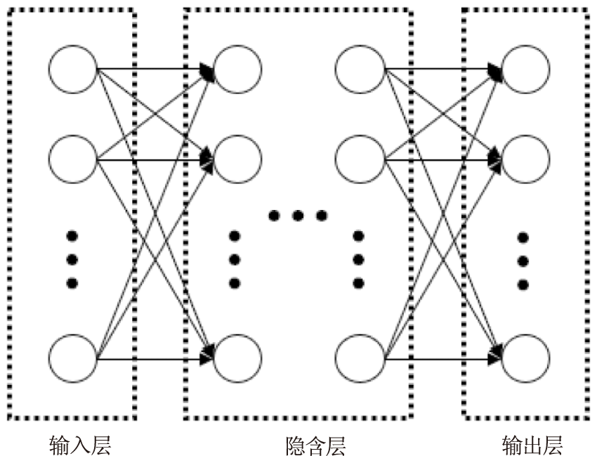
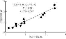
Fig.5
LAI from field measurement and point cloud estimation
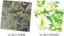
Fig.6
Comparison of the LAI with DOM of the survey area
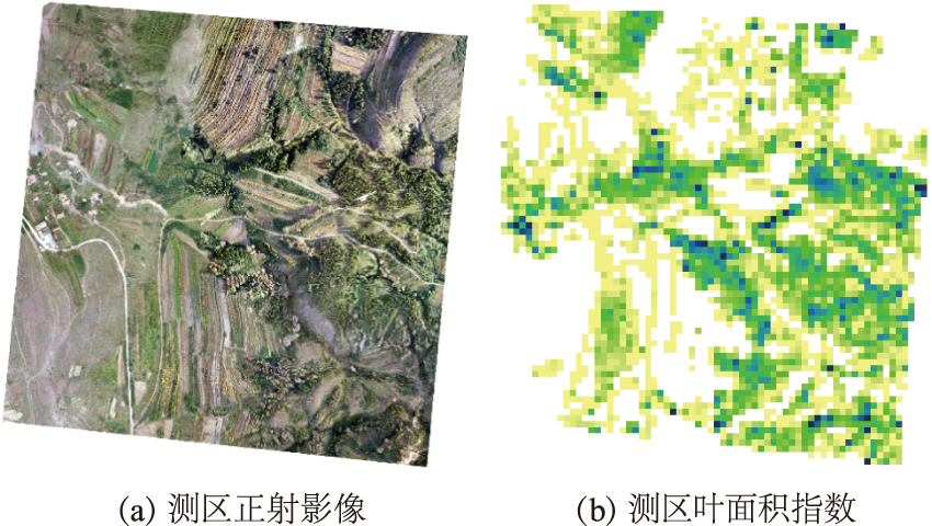

Fig.7
Relationship between above-ground biomass and LAI' × H
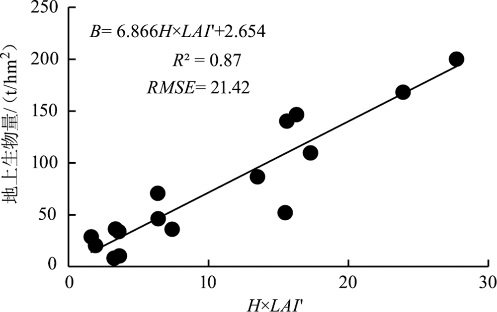

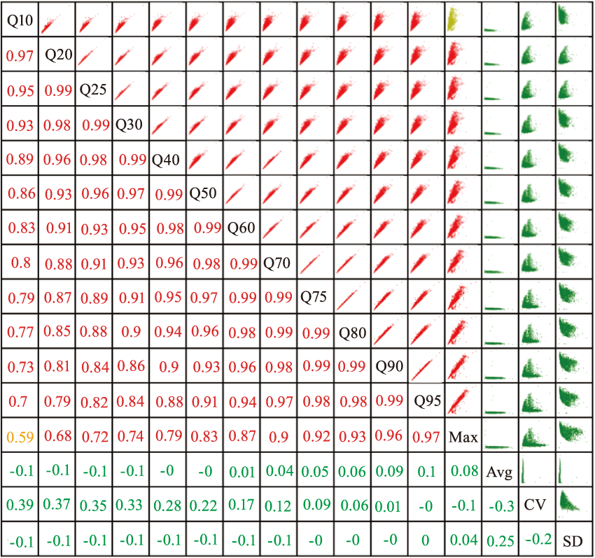
Fig.8
Correlation analysis of waveform parameters
Tab.4
Univariate linear regression model parameters and fit results
| 输入变量 | R2 | Adj.R2 | MAE/(t/hm2) | RMSE/(t/hm2) | RMSEr/% | ||
|---|---|---|---|---|---|---|---|
| Q10 | [1.263] | 45.067 | 0.01 | 0.01 | 26.79 | 38.99 | 15.27 |
| Q25 | [2.297] | 36.302 | 0.05 | 0.05 | 25.83 | 38.26 | 14.98 |
| Q50 | [3.419] | 23.167 | 0.14 | 0.14 | 23.31 | 36.40 | 14.25 |
| Q75 | [4.601] | 11.668 | 0.26 | 0.26 | 21.81 | 33.67 | 13.19 |
| Q95 | [4.131] | 3.678 | 0.40 | 0.40 | 20.29 | 27.88 | 10.92 |
| Max | [3.735] | 2.625 | 0.49 | 0.49 | 21.13 | 30.35 | 11.88 |
| Avg | [2.057] | 48.043 | 0.01 | 0.01 | 26.74 | 38.92 | 15.24 |
| CV | [-9.357] | 66.130 | 0.07 | 0.07 | 26.97 | 37.86 | 11.83 |
| SD | [76.263] | 34.017 | 0.01 | 0.01 | 27.15 | 38.96 | 15.26 |
Tab.5
Parameters of MLR model
| 编号 | 波形参数组合 | ||
|---|---|---|---|
| 1 | Avg,CV,SD | [0.423,-10.109,-35.482] | 74.666 |
| 2 | Q25,Q50,Q75 | [-3.503,-7.643,12.551] | 14.323 |
| 3 | Q10,Q50,Q95 | [-2.014,-4.683,7.631] | 11.499 |
| 4 | Q10,Q75,Q95 | [-2.336,-6.626,9.844] | 11.534 |
| 5 | Q10,Q50,Max | [-0.993,-1.858,4.682] | 10.311 |
| 6 | Q10,Q25,Q50 | [-2.534,-7.793,11.455] | 31.133 |
| 7 | Q50,Q75,Q95 | [-3.218,-5.908,10.787] | 10.976 |
| 8 | Q50,Q75,Max | [-4.641,2.380,4.316] | 9.926 |
| 9 | Q75,Q95,Max | [-7.749,7.178,2.679] | 9.198 |
| 10 | Q10,Q25,Q50,Q75,Q95 | [-1.897,-0.935,0.223,-7.099,10.619] | 11.493 |
| 11 | Q10,Q25,Q50,Q75,Q95,Max | [-0.847,-1.295,-0.015,-5.287,6.608,2.218] | 10.363 |
| 12 | Q10,Q25,Q50,Q75,Q95,Max,Avg,CV,SD | [-2.105,-2.792,-0.809,4.231,8.881,1.419,0.833,13.184,138.172] | -46.816 |
| 13 | ALL* | [-1.131,-4.441,1.826,-0.799,-0.863,1.066,-1.685,-2.498,4.522,-9.013,6.122,5.783,0.895,13.100,1.543,137.889] | -46.717 |
Tab.6
Comparison of AGB estimated by MLR and MLP based on 13 parameter groups
| 编号 | 参数组合 | R2 (MLR|MLP) | Adj.R2 (MLR|MLP) | MAE(t/hm2) (MLR|MLP) | RMSE(t/hm2) (MLR|MLP) | RMSEr/% (MLR|MLP) |
|---|---|---|---|---|---|---|
| 1 | Avg,CV,SD | 0.07|0.23 | 0.07|0.22 | 26.75|23.39 | 37.81|36.62 | 14.80|14.34 |
| 2 | Q25,Q50,Q75 | 0.43|0.44 | 0.43|0.44 | 19.57|16.58 | 29.60|31.18 | 11.59|12.18 |
| 3 | Q10,Q50,Q95 | 0.53|0.66 | 0.53|0.66 | 19.05|13.44 | 26.75|24.31 | 10.47|9.52 |
| 4 | Q10,Q75,Q95 | 0.55|0.71 | 0.54|0.71 | 18.92|12.73 | 26.43|22.31 | 10.35|8.74 |
| 5 | Q10,Q50,Max | 0.54|0.77 | 0.54|0.77 | 19.46|11.12 | 26.70|19.97 | 10.46|7.81 |
| 6 | Q10,Q25,Q50 | 0.28|0.42 | 0.28|0.41 | 20.76|17.83 | 33.33|31.90 | 13.05|12.49 |
| 7 | Q50,Q75,Q95 | 0.54|0.69 | 0.53|0.68 | 19.34|12.24 | 26.73|23.35 | 10.47|9.14 |
| 8 | Q50,Q75,Max | 0.54|0.78 | 0.54|0.77 | 19.64|11.04 | 26.66|19.69 | 10.44|7.71 |
| 9 | Q75,Q95,Max | 0.55|0.76 | 0.55|0.76 | 19.40|11.79 | 26.27|20.30 | 10.29|7.95 |
| 10 | Q10,Q25,Q50,Q75,Q95 | 0.55|0.75 | 0.54|0.74 | 18.96|11.97 | 26.42|20.90 | 10.35|8.18 |
| 11 | Q10,Q25,Q50,Q75,Q95,Max | 0.56|0.76 | 0.56|0.75 | 19.12|11.15 | 26.04|20.62 | 10.20|8.08 |
| 12 | Q10,Q25,Q50,Q75,Q95,Max,Avg,CV,SD | 0.60|0.77 | 0.60|0.76 | 17.44|10.81 | 24.74|19.97 | 9.69|7.82 |
| 13 | ALL | 0.60|0.80 | 0.60|0.79 | 17.45|10.48 | 24.66|18.52 | 9.65|7.25 |

Fig.9
RMSE trend of forest AGB of MLP (No.12)along with epoch
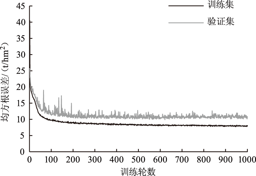
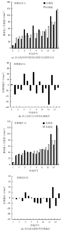
Fig.10
Estimation results of MLP and MLR

| [1] | Fang Jingyun, Yu Guirui, Liu Lingli, et al. Climate change,human impacts,and carbon sequestration in China[J]. Proceedings of the National Academy of Sciences, 2018,115(16):4015-4020. |
| [2] | Nascimento H E M, Laurance W F. Total above-ground biomass in central Amazonian rainforests:a landscape-scale study[J]. Forest ecology and management, 2002,168(1-3):311-321. |
| [3] | Nie Sheng, Wang Cheng, Zeng Hongcheng, et al. Above-ground biomass estimation using airborne discrete-return and full-waveform LiDAR data in a coniferous forest[J]. Ecological Indicators, 2017,78:221-228. |
| [4] | 刘茜, 杨乐, 柳钦火, 等. 森林地上生物量遥感反演方法综述[J]. 遥感学报, 2015,19(1):62-74. |
| [5] | 刘清旺, 李增元, 陈尔学, 等. 机载LIDAR点云数据估测单株木生物量[J]. 高技术通讯, 2010,7:765-770. |
| [6] | 洪奕丰, 张守攻, 陈伟, 等. 基于机载激光雷达的落叶松组分生物量反演[J]. 林业科学研究, 2019(5):12. |
| [7] | Margolis H A, Nelson R F, Montesano P M, et al. Combining satellite lidar,airborne lidar,and ground plots to estimate the amount and distribution of above-ground biomass in the boreal forest of North America[J]. Canadian Journal of Forest Research, 2015,45(7):838-855. |
| [8] | Muss J D, Mladenoff D J, Townsend P A. A pseudo-waveform technique to assess forest structure using discrete lidar data[J]. Remote Sensing of Environment, 2011,115(3):824-835. |
| [9] | 吴娇娇, 欧光龙, 舒清态. 基于BP神经网络模型思茅松天然林生物量遥感估测[J]. 中南林业科技大学学报, 2017,37(7):30-35. |
| [10] | 孙翊, 姜树海, 陈至灵. 人工神经网络在林业上的应用研究进展[J]. 世界林业研究, 2019,32(3):7-12. |
| [11] | 徐辉, 潘萍, 宁金魁, 等. 多元线性回归与神经网络模型在森林地上生物量遥感估测中的应用[J]. 东北林业大学学报, 2018,46(1):63-67. |
| [12] | 徐奇刚, 雷相东, 国红, 等. 基于多层感知机的长白落叶松人工林林分生物量模型[J]. 北京林业大学学报, 2019,41(5):97-107. |
| [13] |
Le Cun Y, Bengio Y, Hinton G. Deep learning[J]. nature, 2015,521(7553):436-444.
doi: 10.1038/nature14539 pmid: 26017442 |
| [14] | 罗云建, 张小全, 王效科, 等. 华北落叶松人工林生物量及其分配模式[J]. 北京林业大学学报, 2009,6(1):13-18. |
| [15] | 白静. 油松人工林生长特征及其与林分结构关系研究[D]. 呼和浩特:内蒙古农业大学, 2008. |
| [16] | 吴俊民, 苏贵林, 刘成志, 等. 黑龙江省西部杨树人工林生物量的估算方法[J]. 林业科技, 2000(3):14-16. |
| [17] | Wang Chuankuan. Biomass allometric equations for 10 co-occurring tree species in Chinese temperate forests[J]. Forest Ecology and Management, 2006,222(1-3):9-16. |
| [18] | 贾炜玮, 于爱民. 樟子松人工林单木生物量模型研究[J]. 林业科技情报, 2008,40(2):1-2 |
| [19] |
Hancock S, Armston J, Hofton M, et al. The GEDI simulator:a large-footprint waveform Lidar simulator for calibration and validation of spaceborne missions[J]. Earth and Space Science, 2019,6(2):294-310.
doi: 10.1029/2018EA000506 pmid: 31008149 |
| [20] |
Chen J M, Pavlic G, Brown L, et al. Derivation and validation of Canada-wide coarse-resolution leaf area index maps using high-resolution satellite imagery and ground measurements[J]. Remote Sensing of Environment, 2002,80(1):165-184.
doi: 10.1016/S0034-4257(01)00300-5 |
| [21] |
Richardson J J, Moskal L M, Kim S H. Modeling approaches to estimate effective leaf area index from aerial discrete-return LIDAR[J]. Agricultural and Forest Meteorology, 2009,149(6-7):1152-1160.
doi: 10.1016/j.agrformet.2009.02.007 |
| [22] |
Hyer E J, Goetz S J. Comparison and sensitivity analysis of instruments and radiometric methods for LAI estimation:assessments from a boreal forest site[J]. Agricultural and Forest Meteorology, 2004,122(3-4):157-174.
doi: 10.1016/j.agrformet.2003.09.013 |
| [23] | 张志, 田昕, 陈尔学, 等. 森林地上生物量估测方法研究综述[J]. 北京林业大学学报, 2011,33(5):144-150. |
| [24] | Goodfellow I, Bengio Y, Courville A. Deep learning[M]. Cambridge,MA:MIT press, 2016. |
| [1] | LIU Yingchun, GAO Xianlian, HE Yan, CUI Chenyan, GAO Jianxin, YU Jiayong, CAI Longtao, WU Fayun. Calibration and Validation of National Forest and Grassland Inventory Airborne Large-Footprint LiDAR [J]. FOREST RESOURCES WANAGEMENT, 2021, 0(2): 52-60. |
| [2] | DAI Huabing, LI Chungan, PANG Yong, LI Chonggui. Method for Sub-compartment Investigation Factors Setting and Information Acquisition Based on Integrated Aerial-Space-Ground Forest Inventory System [J]. FOREST RESOURCES WANAGEMENT, 2021, 0(1): 180-188. |
| [3] | XU Can, JIANG Tengda. A Method of Estimating Forest Stock Volume Parameters from Airborne LiDAR Data [J]. FOREST RESOURCES WANAGEMENT, 2020, 0(3): 105-110. |
| [4] | SUN Zhongqiu, WU Fayun, GAO Xianlian, GAO Jinping, HU Yang. Estimation of Forest Canopy Height Based on Large-Footprint Airborne LiDAR Data [J]. FOREST RESOURCES WANAGEMENT, 2020, 0(3): 111-117. |
| [5] | MA Hongwei, LIU Hai, YAO Shunbin, ZHOU Wei. Analysis and Prospect on the Application of Tree Species Classification Based on Forestry Remote Sensing [J]. FOREST RESOURCES WANAGEMENT, 2020, 0(3): 118-121. |
| [6] | LIN Xin, PANG Yong, LI Chungan. Analysis of the Deference Between the UAV Dense Matching Point Cloud and Airborne LiDAR Point Cloud [J]. FOREST RESOURCES WANAGEMENT, 2020, 0(3): 58-62. |
| [7] | Hongbin LUO, Qingtai SHU, Yong PANG, Qiang WANG, Dongling WANG. Analysis of Sampling Size Effect of Aboveground Biomass Estimation of Rubber Forest Using Airborne LiDAR Data [J]. FOREST RESOURCES WANAGEMENT, 2020, 0(1): 136-142. |
| [8] | WU Fayun, GAO Xianlian, PAN Chao, SUN Zhongqiu, WANG Lidong, LIU Yingchun. Design and Application of Forest Detecting Based on Airborne Large-Footprint LiDAR System [J]. FOREST RESOURCES WANAGEMENT, 2018, 0(4): 125-132. |
| [9] | WANG Weibin, DANG Yongfeng, ZENG Weisheng. Compatible Tree Volume and Above-ground Biomass Equations for Larch(Larix spp.)in Northeastern China [J]. FOREST RESOURCES WANAGEMENT, 2012, 0(2): 69-73. |
| [10] | DUAN Zhugeng, XIAO Huashun. Review of Methods for Forest Parameter Estimation with LiDAR [J]. FOREST RESOURCES WANAGEMENT, 2011, 0(4): 117-121. |
| [11] | ZHANG Yanlin, FENG Zhongke, YANG Bogang, MA Youping, YAO Shan. Applications of LIDAR Technology in Forestry Investigation [J]. FOREST RESOURCES WANAGEMENT, 2007, 0(6): 73-77. |
| Viewed | ||||||
|
Full text |
|
|||||
|
Abstract |
|
|||||