

FOREST RESOURCES WANAGEMENT ›› 2023, Vol. 0 ›› Issue (3): 90-97.doi: 10.13466/j.cnki.lyzygl.2023.03.012
• Scientific Research • Previous Articles Next Articles
ZHOU Mei1( ), LI Chungan2(), YANG Chengling3, LI Zhen3
Received:2023-04-28
Revised:2023-05-19
Online:2023-06-28
Published:2023-08-09
CLC Number:
ZHOU Mei, LI Chungan, YANG Chengling, LI Zhen. Experiments on Estimating Planted Forest Inventory Attributes Based on UAV-LiDAR Data[J]. FOREST RESOURCES WANAGEMENT, 2023, 0(3): 90-97.
Add to citation manager EndNote|Ris|BibTeX
URL: http://www.lyzygl.com.cn/EN/10.13466/j.cnki.lyzygl.2023.03.012
Tab.1
Summary statistics of the field plot data
| 森林类型 | 样地数量 | 林木密度/ (株/hm2) | 平均直径 | 平均高 | 断面积 | 蓄积量 | |||||||
|---|---|---|---|---|---|---|---|---|---|---|---|---|---|
| 均值/ cm | CV/ % | 均值/ cm | CV/ % | 均值/ (m2/hm2) | CV/ % | 均值/ (m3/hm2) | CV/ % | ||||||
| 松树林 | 33 | 717~2 233 | 26.2 | 24.6 | 17.5 | 26.2 | 32.9 | 23.4 | 242.7 | 30.5 | |||
| 桉树林 | 35 | 1 067~3 450 | 11.1 | 28 | 15.2 | 30.6 | 18.3 | 53.9 | 150.6 | 65.3 | |||
Tab.2
List of UAV-LiDAR-derived metrics used for establishing the predictive models
| 变量 | 含义 | 冠层三维结构的刻画角度 | 变量组 |
|---|---|---|---|
| hp95 | 95%分位数高度 | 冠层高度 | 高度变量 |
| Hmean | 点云平均高 | 冠层高度 | 高度变量 |
| Hstd | 点云高度的标准差 | 冠层高度 | 高度变量 |
| Hcv | 点云高度的变动系数 | 冠层高度 | 高度变量 |
| CC | 郁闭度(修正) | 冠层密度 | 密度变量 |
| dp50 | 50%分位数密度 | 冠层密度 | 密度变量 |
| dp75 | 75%分位数密度 | 冠层密度 | 密度变量 |
| LADmean | 叶面积密度均值 | 垂直结构异质性 | 垂直结构变量 |
| LADstd | 叶面积密度标准差 | 垂直结构异质性 | 垂直结构变量 |
| LADcv | 叶面积密度变动系数 | 垂直结构异质性 | 垂直结构变量 |
| VFPmean | 枝叶垂直剖面均值 | 垂直结构异质性 | 垂直结构变量 |
| VFPstd | 枝叶垂直剖面标准差 | 垂直结构异质性 | 垂直结构变量 |
| VFPcv | 枝叶垂直剖面变动系数 | 垂直结构异质性 | 垂直结构变量 |
Tab.3
The best model formulation for estimating forest inventory attributes
| 森林类型 | 森林参数 | 模型式 |
|---|---|---|
| 松树林 | 蓄积量(VOL)/m3 | VOLPine=a0Hmeana1CCa2VFPstda3Hstda4dp75a5 |
| 断面积(BA)/m2 | BAPine=a0Hmeana1CCa2VFPstda3Hcva4dp50a5 | |
| 平均高(H)/m | HPine=a0hp60a1hp70a2hp80a3CCa4dp50a5 | |
| 桉树林 | 蓄积量(VOL)/m3 | VOLEucalyptus=a0hp95a1CCa2VFPstda3Hcva4dp75a5 |
| 断面积(BA)/m2 | BAEucalyptus=a0hp95a1CCa2VFPstda3Hstda4dp75a5 | |
| 平均高(H)/m | HEucalyptus=a0hp60a1hp80a2 |
Tab.4
Model parameters and their good-of-fit and validation statistics
| 森林 类型 | 森林 参数 | 样地 数量 | 模型参数估计值 | 修正因子 (CF) | 拟合指标 | 检验指标 | |||||||||||||||||||
|---|---|---|---|---|---|---|---|---|---|---|---|---|---|---|---|---|---|---|---|---|---|---|---|---|---|
| a0 | a1 | a2 | a3 | a4 | a5 | R2 | rRMSE/ % | MPE/ % | R2 | rRMSE/ % | MPE/ % | ||||||||||||||
| 松树林 | VOL | 33 | 0.172 70 | 1.474 9 | 1.329 4 | -0.163 6 | -0.263 800 | -1.381 2 | 1.009 8 | 0.783 | 12.44 | 4.69 | 0.708 | 13.86 | 5.36 | ||||||||||
| BA | 33 | 0.694 70 | 0.701 1 | 0.887 0 | -0.204 4 | -0.365 000 | -0.981 7 | 1.008 4 | 0.676 | 11.94 | 4.51 | 0.616 | 14.26 | 5.04 | |||||||||||
| H | 33 | -0.080 12 | -5.177 1 | 8.299 5 | -2.391 0 | 1.136 600 | -1.012 3 | 1.007 0 | 0.846 | 10.30 | 3.88 | 0.794 | 11.06 | 4.15 | |||||||||||
| 桉树林 | VOL | 35 | -0.288 50 | 1.837 9 | 0.661 7 | 0.211 3 | -0.002 804 | 0.144 5 | 1.018 4 | 0.943 | 15.71 | 5.82 | 0.853 | 17.79 | 6.22 | ||||||||||
| BA | 35 | -0.453 30 | 1.252 4 | 0.592 9 | 0.132 7 | -0.054 760 | 0.161 8 | 1.019 1 | 0.903 | 15.91 | 5.89 | 0.844 | 16.72 | 6.72 | |||||||||||
| H | 35 | 0.055 13 | -2.560 6 | 3.471 9 | 1.005 9 | 0.899 | 9.87 | 3.59 | 0.833 | 10.85 | 3.81 | ||||||||||||||

Fig.1
Distribution of relative residual errors for models with three attributes for two forest types
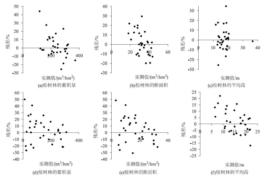

Fig.2
Wall-to-wall maps of three forest inventory attributes for two forest types

| [1] |
Næsset E T. Gobakken J, Holmgren H, et al. Laser scanning of forest resources:The Nordic experience[J]. Scandinavian Journal of Forest Research, 2004, 19(6):482-499.
doi: 10.1080/02827580410019553 |
| [2] | White J C, Tompalski P, Vastaranta M, et al. A model development and application guide for generating an enhanced forest inventory using airborne laser scanning data and an area-based approach[R]. Victoria: Canadian Wood Fibre Centre, 2017. |
| [3] | 李春干, 李振. 机载激光雷达大区域亚热带森林参数估测的普适性模型式[J]. 林业科学, 2021, 57(10):23-35. |
| [4] | 代华兵, 李春干, 庞勇, 等. 基于天空地一体化森林资源调查的小班因子设置与信息获取方法[J]. 林业资源管理, 2021(2):180-188. |
| [5] | 李春干, 代华兵. 中国森林资源调查:历史、现状与趋势[J]. 世界林业研究, 2021, 34(6):72-80. |
| [6] |
Sankey T, Donager J, McVay J, et al. UAV lidar and hyperspectral fusion for forest monitoring in the southwestern USA[J]. Remote Sensing of Environment, 2017, 195:30-43.
doi: 10.1016/j.rse.2017.04.007 |
| [7] |
Liu Kun, Shen Xin, Cao Lin, et al. Estimating forest structural attri-butes using UAV-LiDAR data in Ginkgo plantations[J]. ISPRS Journal of Photogrammetry and Remote Sensing, 2018, 146:465-482.
doi: 10.1016/j.isprsjprs.2018.11.001 |
| [8] |
Cao Lin, Liu Kun, Shen Xin, et al. Estimation of forest structural parameters using UAV-LiDAR data and a process-based model in Ginkgo planted forests[J]. IEEE Journal of Selected Topics in Applied Earth Observations and Remote Sensing, 2019, 12(11):4175-4190.
doi: 10.1109/JSTARS.2019.2918572 |
| [9] |
D'Oliveira M V N, Broadbent E N, Oliveira L C, et al. Aboveground biomass estimation in Amazonian Tropical Forests:A comparison of aircraft- and gatorEye UAV-borne LiDAR data in the chico mendes extractive reserve in Acre,Brazil[J]. Remote Sensing, 2020, 12:1754.
doi: 10.3390/rs12111754 |
| [10] |
Corte A P D, de Vasconcello B N, Rex F E, et al. Applying high-resolution UAV-LiDAR and quantitative structure modelling for estimating tree attributes in a crop-livestock-forest system[J]. Land, 2022, 11:507.
doi: 10.3390/land11040507 |
| [11] |
Xu Dandan, Wang Haobin, Xu Weixin, et al. LiDAR applications to estimate forest biomass at individual tree scale:Opportunities,challenges and future perspectives[J]. Forests, 2021, 12(5):550.
doi: 10.3390/f12050550 |
| [12] |
Corte A P D, Souza D V, Rex F E, et al. Forest inventory with high-density UAV-Lidar:Machine learning approaches for predicting individual tree attributes[J]. Computers and Electronics in Agriculture, 2020, 179:105815.
doi: 10.1016/j.compag.2020.105815 |
| [13] |
Cao Lin, Liu Kai, Shen Xin, et al. Estimation of forest structural parameters using UAV-LiDAR data and a process-based model in Ginkgo planted forests[J]. IEEE Journal of Selected Topics in Applied Earth Observations and Remote Sensing, 2019, 12(11):4175-4189.
doi: 10.1109/JSTARS.2019.2918572 |
| [14] |
Peng Xi, Zhao Anjiu, Chen Yongfu, et al. Comparison of modeling algorithms for forest canopy structures based on UAV-LiDAR:A case study in tropical china[J]. Forests, 2020, 11:1324.
doi: 10.3390/f11121324 |
| [15] |
Neuville R Bates J S, Jonard F. Estimating forest structure from UAV-mounted LiDAR point cloud using machine learning[J]. Remote Sensing, 2021, 13:352.
doi: 10.3390/rs13030352 |
| [16] |
Næset E. Predicting forest stand characteristics with airborne scanning laser using a practical two-stage procedure and field data[J]. Remote Sensing of Environment, 2002, 80(1):88-99.
doi: 10.1016/S0034-4257(01)00290-5 |
| [17] | 周梅, 王新华, 李春干, 等. 不同样地面积对人工林林分参数的影响[J]. 西部林业科学, 2018, 47(1):110-116. |
| [18] |
Li Chungan, Lin Xin, Dai Huabing, et al. Effects of plot size on airborne LiDAR-derived metrics and predicted model performances of subtropical planted forest attributes[J]. Forests, 2022, 13:2124.
doi: 10.3390/f13122124 |
| [19] | Li Chungan, Chen Zhongchao, Zhou Xiangbei, et al. Generalized models for subtropical forest inventory attribute estimations using a rule-based exhaustive combination approach with airborne LiDAR-derived metrics[J]. Giscience & Rremote Sensing, 2023, 60(1):2194601. |
| [20] |
Ferster C J, Coops N C, Trofymow J A. Aboveground large tree mass estimation in a coastal forest in British Columbia using plot-level metrics and individual tree detection from lidar[J]. Canadian Journal of Remote Sensing, 2009, 35(3):270-275.
doi: 10.5589/m09-014 |
| [21] |
Hall S A, Burke I C, Box D O, et al. Estimating stand structure using discrete-return lidar:An example from low density,fire prone ponderosa pine forests[J]. Forest Ecology and Management, 2005, 208(1):189-209.
doi: 10.1016/j.foreco.2004.12.001 |
| [22] | 曾伟生, 唐守正. 立木生物量方程的优度评价和精度分析[J]. 林业科学, 2011, 47(11):106-113. |
| [23] |
Coops N C, Tompalski P, Goodbody T R H, et al. Modelling lidar-derived estimates of forest attributes over space and time:A review of approaches and future trends[J]. Remote Sensing of Environment, 2021, 260:112477.
doi: 10.1016/j.rse.2021.112477 |
| [24] |
Gobakken T, Næsset E. Assessing effects of laser point density,ground sampling intensity,and field sample plot size on biophysical stand properties derived from airborne laser scanner data[J]. Canadian Journal of Forest Research, 2008, 38:1095-1109.
doi: 10.1139/X07-219 |
| [25] | 余铸, 李春干, 苏凯. 等. 基于垂直结构分类的机载激光雷达森林参数估测[J/OL]. 桂林理工大学学报.(2022-05-06)[2023-05-16]. http://kns.cnki.net/kcms/detail/45.1375.n.20220429.1213.002.html. |
| [26] | 曾伟生, 孙乡楠, 王六如, 等. 基于机载激光雷达数据的森林蓄积量模型研建[J]. 林业科学, 2021, 57(2):31-38. |
| [27] |
Liu Hao, Cao Lin, She Guanghui, et al. Extrapolation assessment for forest structural parameters in planted Forests of southern China by UAV-LiDAR samples and multispectral satellite imagery[J]. Remote Sensing, 2022, 14(11):2677.
doi: 10.3390/rs14112677 |
| [1] | HUA Weiping, WU Jianwei, YU Liyao, WANG Yanan, WU Chengzhen, ZHUANG Chongyang, CHI Shangping, JIANG Xidian. Forestland Grading Based on Forest Potential Productivity Evaluation Model and Its Application [J]. FOREST RESOURCES WANAGEMENT, 2023, 0(3): 29-37. |
| [2] | LIANG Licheng, FU Xiaoqiang, ZHANG Bin, CHENG Guxun, LI Zuohui. Dynamic Monitoring of Spartina alterniflora in Xiangshan Harbor Based on GEE and Random Forest [J]. FOREST RESOURCES WANAGEMENT, 2023, 0(3): 38-45. |
| [3] | JIN Yu, WANG Juan, YANG Yue, YANG Xiongwei, MA Huimin. Impacts of Land Use Changes on the Habitat of Asian Elephants in Simao District of Yunnan [J]. FOREST RESOURCES WANAGEMENT, 2023, 0(3): 46-55. |
| [4] | ZHANG Huifang, ZHU Yali, ZHANG Jinglu, GAO Jian, DILIXIATI·Baoerhan . Above-Ground Biomass Prediction of Arbor Forest in Altay Mountain Area Based on High-Resolution Remote Sensing Data [J]. FOREST RESOURCES WANAGEMENT, 2023, 0(2): 104-110. |
| [5] | YU Zhucheng, XU Linli, LUO Shuigen, WANG Meifang, ZHOU Xiao, CHEN Danna, JIN Wei. Assessment on Habitat Suitability of Macaca thibetana in Xianxialing Provincial Nature Reserve Using MaxEnt Modeling [J]. FOREST RESOURCES WANAGEMENT, 2023, 0(2): 111-117. |
| [6] | ZENG Weisheng, YANG Xueyun. Analysis of General Status and Examination of Estimation Errors for One-Variable Tree Volume Tables in China [J]. FOREST RESOURCES WANAGEMENT, 2023, 0(2): 43-49. |
| [7] | XIE Wenchun, LI Qiangfeng, LI Yanchun, WU Zhenshan, YANG Zhengfan. Object-Oriented Classification of Wetland Vegetation Community in Jilin-1 Remote Sensing Image [J]. FOREST RESOURCES WANAGEMENT, 2023, 0(1): 141-152. |
| [8] | ZENG Weisheng, YANG Xueyun. Analysis of Timber Forest Resources Status and Timber Safety Analysis in China [J]. FOREST RESOURCES WANAGEMENT, 2023, 0(1): 17-24. |
| [9] | ZHA Feiyun, XU Jin, YAN Hongxiang, CHEN Huimin, LAI Zhihui. Research on the Integration and Optimization of Natural Protected Areas based on Early Warning Evaluation of Human Disturbance [J]. FOREST RESOURCES WANAGEMENT, 2023, 0(1): 25-33. |
| [10] | ZHANG Quanlin, LIU Lihua, AN Xiongtao, LIU Yang. Exploration on the Assessment of Recreation-Based Forest Resource Assets-Taking Jingangku Forest Farm of Wutai Mountain State-Owned Forest Farm Administration as an Example [J]. FOREST RESOURCES WANAGEMENT, 2022, 0(zk1): 79-84. |
| [11] | YANG Xueqing, SUN Zhichao, CHAI Zheng, QIU Yiwen, JIANG Chunying. Research on the Plot Survey and Load Estimation of National Forest Fuels [J]. FOREST RESOURCES WANAGEMENT, 2022, 0(6): 1-6. |
| [12] | ZHANG Min, WANG Jian, HAN Tianyi, OUYANG Xunzhi, PAN Ping, LIU Dongdong. Characteristics of Carbon Density and Its Influencing Factors of Pinus massoniana Forest Based on CBM-CFS3 Model [J]. FOREST RESOURCES WANAGEMENT, 2022, 0(6): 44-53. |
| [13] | SU Shaofeng, LIN Zhipan, WANG Xiaoyan, LEI Xiangling, XUE Yang. Research on the Construction of the Evaluation Index System for the Degradation Degree of Mangrove Wetland Ecosystem in Hainan [J]. FOREST RESOURCES WANAGEMENT, 2022, 0(6): 54-60. |
| [14] | HUANG Xiaofa, ZHANG Wei, CEN Juyan, WU Guoxin, HUANG Shuying. Study on the Optimization and Selection of Cunninghamia lanceolata Standing Volume Model in Guangxi [J]. FOREST RESOURCES WANAGEMENT, 2022, 0(6): 61-67. |
| [15] | NIE Jing, LU Chi, OU Guanglong, XU Hui. Two-Stage Sampling Estimation of Above-Ground Biomass of Pinus kesiya var.langbianensis Based on Remote Sensing Factors from Landsat8 OLI [J]. FOREST RESOURCES WANAGEMENT, 2022, 0(6): 68-75. |
| Viewed | ||||||
|
Full text |
|
|||||
|
Abstract |
|
|||||