

FOREST RESOURCES WANAGEMENT ›› 2023, Vol. 0 ›› Issue (1): 161-172.doi: 10.13466/j.cnki.lyzygl.2023.01.019
• Technical Application • Previous Articles Next Articles
XU Ganjun1( ), WANG Yaping2, LI Xinyang2, GUO Nan2, YANG Mei2, HE Dan2()
Received:2022-12-08
Revised:2023-02-09
Online:2023-02-28
Published:2023-05-05
CLC Number:
XU Ganjun, WANG Yaping, LI Xinyang, GUO Nan, YANG Mei, HE Dan. Exploring the Landscape Diversity of Graded Road Green Spaces Based on UAV Aerial Survey[J]. FOREST RESOURCES WANAGEMENT, 2023, 0(1): 161-172.
Add to citation manager EndNote|Ris|BibTeX
URL: http://www.lyzygl.com.cn/EN/10.13466/j.cnki.lyzygl.2023.01.019

Fig.1
General location map
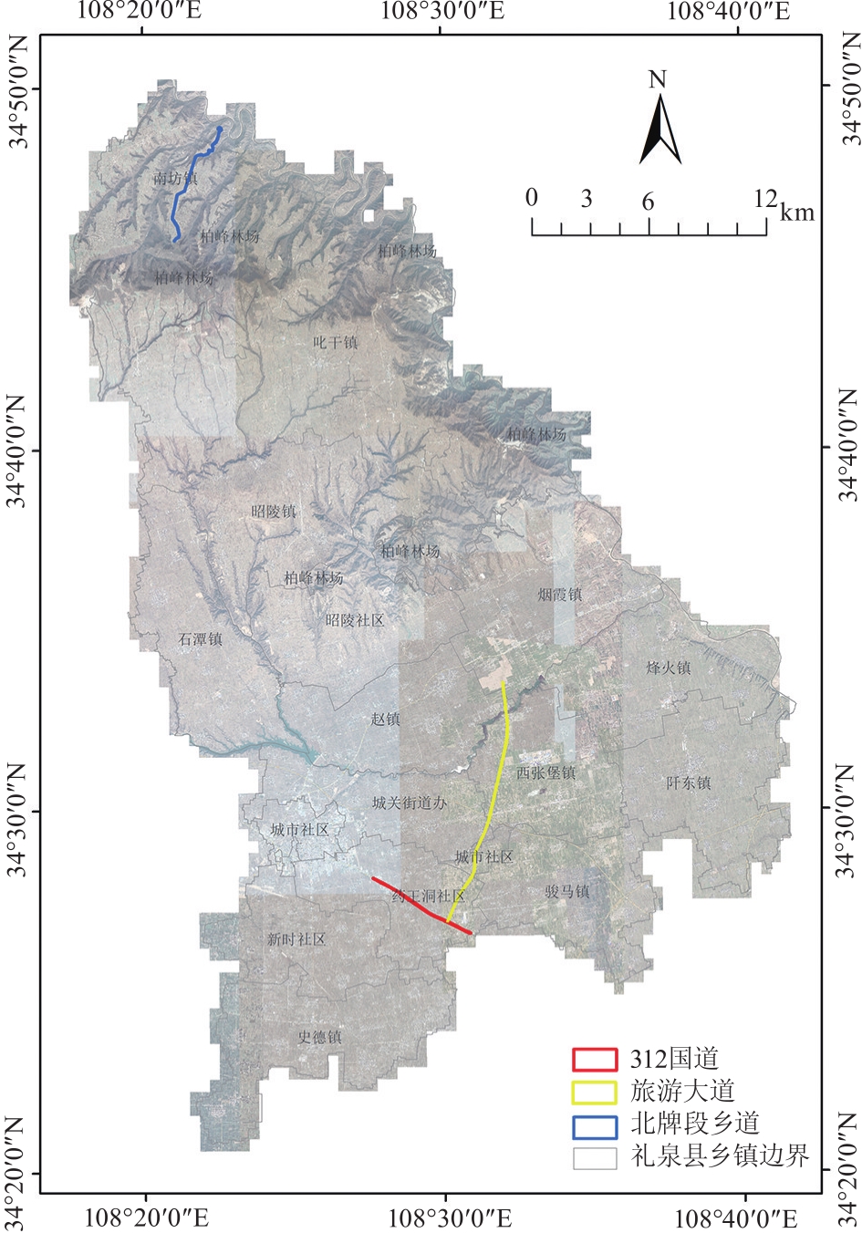
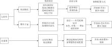
Fig.2
Schematic diagram of the landscape optimization model
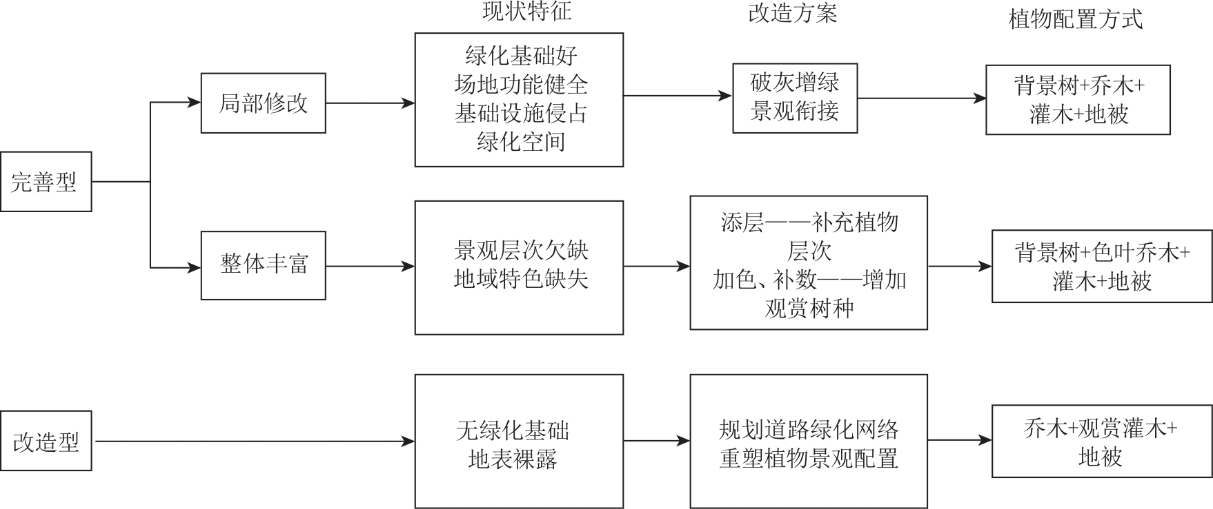
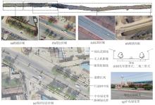
Fig.3
Analysis of the current situation of National Highway 312
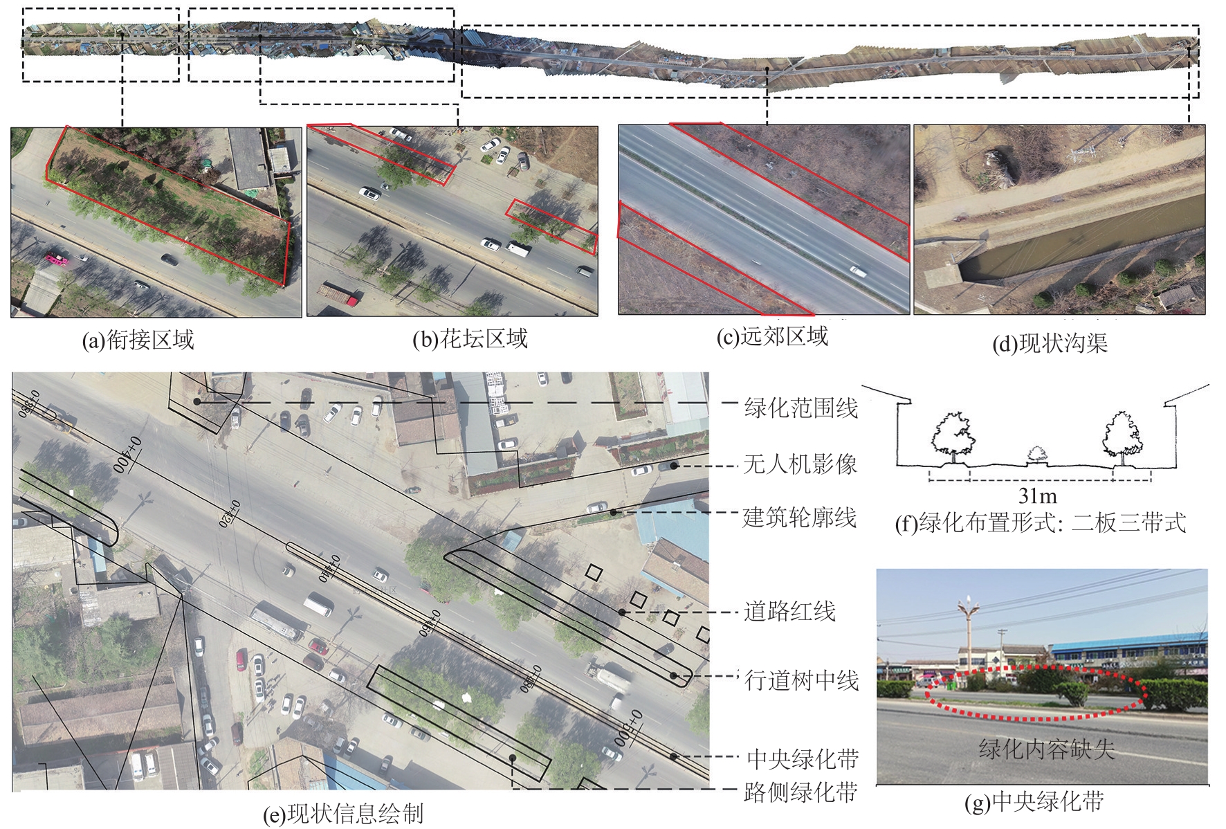
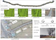
Fig.4
Analysis of the current status of the Tourist Boulevard


Fig.5
Analysis of the current status of the North Pai section of the country road

Tab.1
Landscape pattern application programme
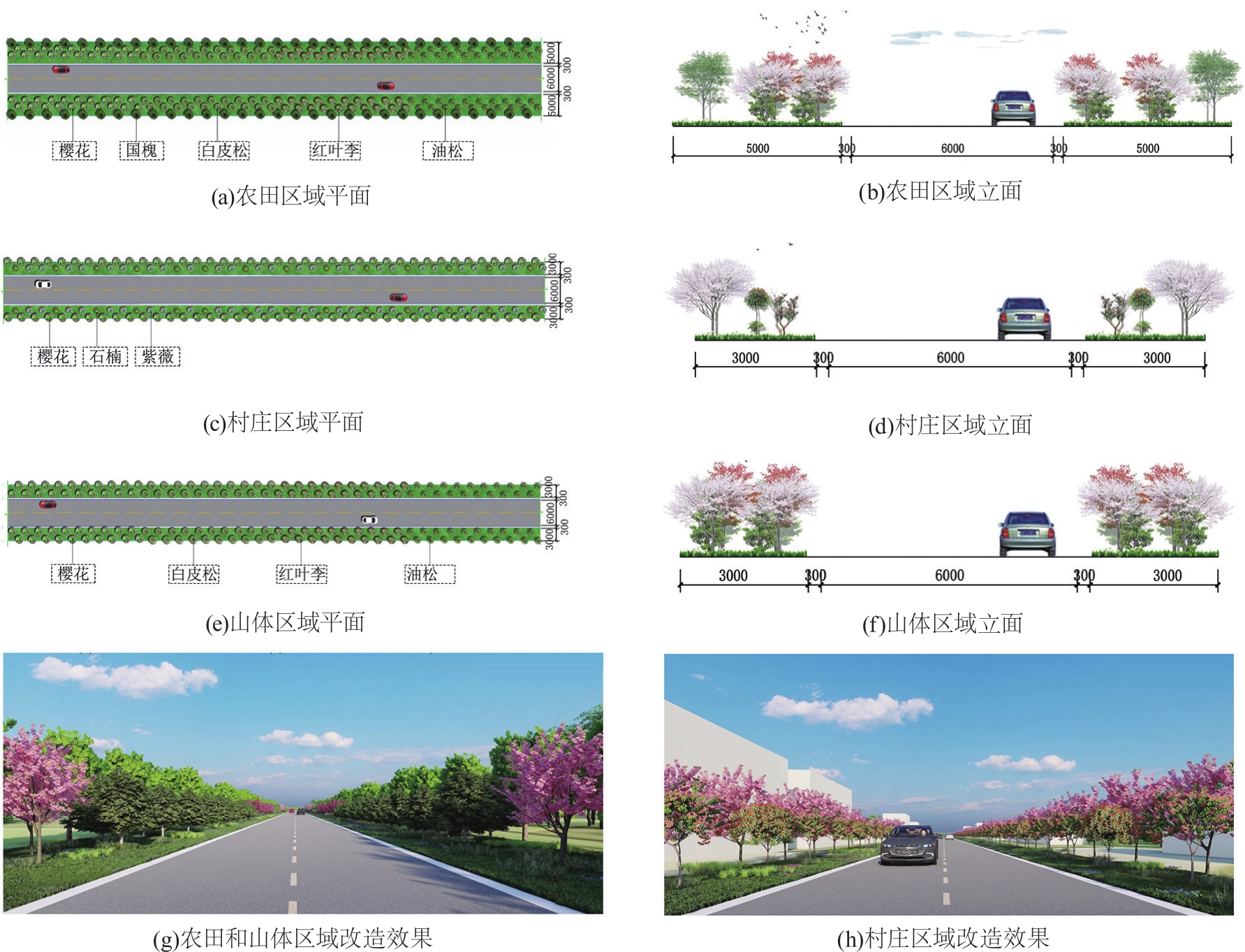
| 景观优化模式 | 区域定位 | 空间描述 | 配置方式 | |
|---|---|---|---|---|
| 完善型 | 局部修改 | 312国道-花坛区域 | 灰色基础设施占据绿化空间,破除硬质铺装,还原花坛空间 | 小乔木+灌木+地被 |
| 312国道-衔接区域 | 路侧至工厂围墙空间充足,营造多层次景观效果 | 背景树+小乔木+灌木+地被 | ||
| 整体丰富 | 312国道-远郊区域 | 空间狭长,以色叶树种划分绿化空间,避免视觉疲劳 | 背景树+色叶树+灌木+地被 (以植物色系划分) | |
| 旅游大道全线 | 地形空间多变,绿化以植物色系划分凸显场地景观特色 | |||
| 改造型 | 完全改造 | 北牌段乡道全线 | 受农田、建筑、山体等要素影响,绿化以生态、美观为主 | 背景树+观赏灌木+地被 |
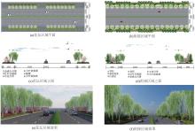
Fig.6
Partial modification mode application diagram
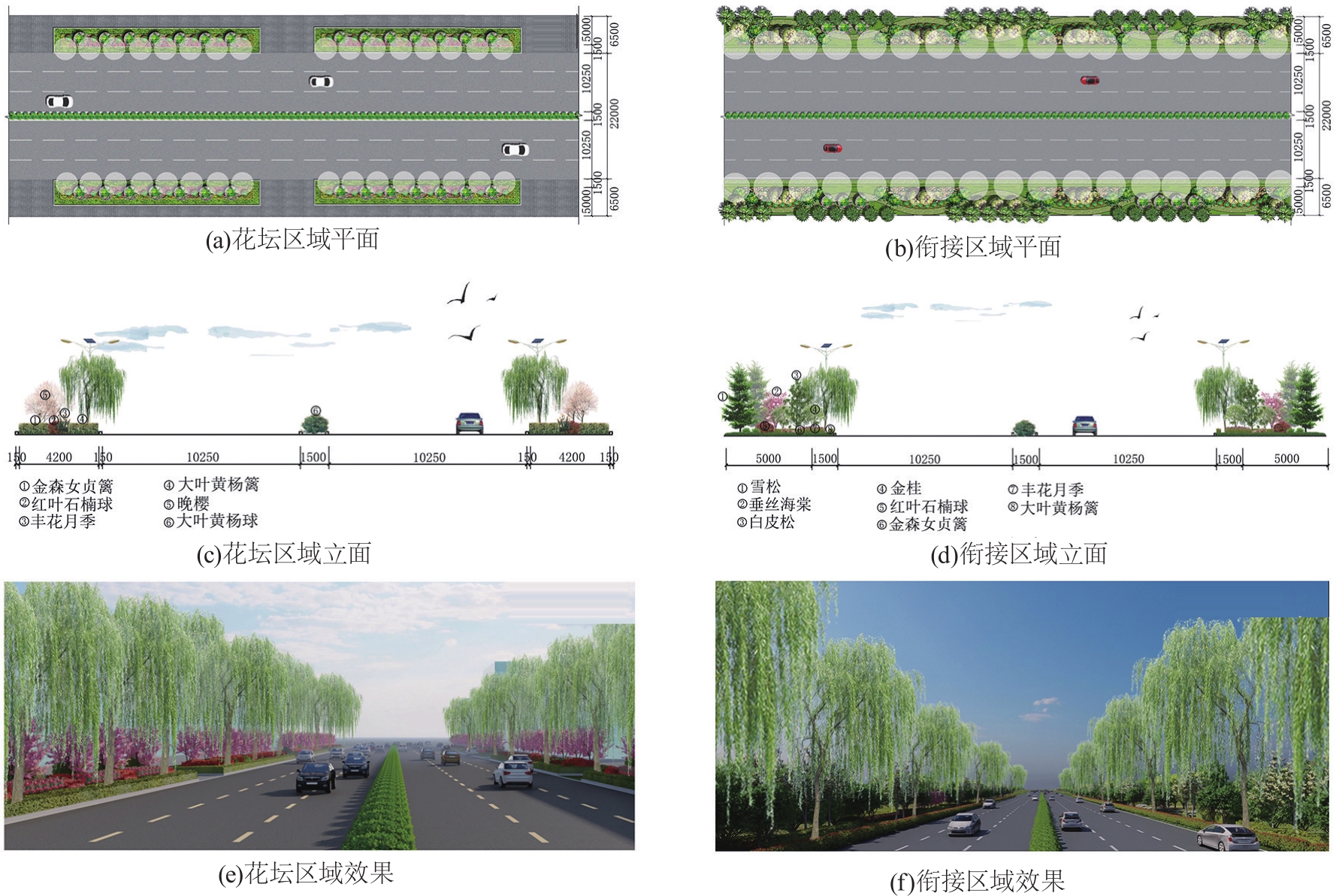
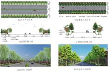
Fig.7
Application map of the overall enrichment model for remote and low terrain areas

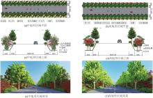
Fig.8
Application map of the overall enrichment model for medium and high terrain areas

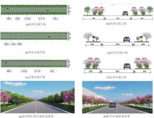
Fig.9
Retrofit mode application diagram
Tab.2
The statistics of plant diversity in the samplesbefore and afteroptimization
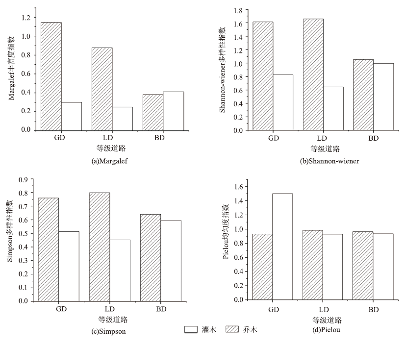
| 道路等级 | 植物 类型 | Shannon-wiener 多样性指数(H') | Simpson 多样性指数(D) | Pielou 均匀度指数(P) | Margalef 丰富度指数(M) | |||||||
|---|---|---|---|---|---|---|---|---|---|---|---|---|
| 前 | 后 | 前 | 后 | 前 | 后 | 前 | 后 | |||||
| 312国道 | 乔木 | 1.313 | 1.613 | 0.591 | 0.760 | 0.946 | 0.931 | 0.642 | 1.145 | |||
| 灌木 | - | 0.826 | - | 0.514 | - | 1.500 | - | 0.300 | ||||
| 旅游大道 | 乔木 | 1.094 | 1.657 | 0.663 | 0.799 | - | 0.982 | - | 0.878 | |||
| 灌木 | - | 0.644 | - | 0.452 | - | 0.929 | - | 0.250 | ||||
| 北牌段乡道 | 乔木 | - | 1.055 | - | 0.640 | - | 0.965 | - | 0.381 | |||
| 灌木 | - | 0.995 | - | 0.594 | - | 0.935 | - | 0.411 | ||||
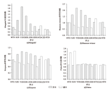
Fig.10
Diversity index by sample area


Fig.11
Road diversity index by class
| [1] | 杨文静, 叶丹, 王姣, 等. 我国城镇化相关环境健康问题分析及对策研究[J]. 环境与健康杂志, 2017, 34(12):1053-1057. |
| [2] | 申勇. 城市道路绿地景观设计研究[D]. 长沙: 中南林业科技大学, 2006. |
| [3] | 张大敏. 城市道路景观的生态设计措施探讨[J]. 中国园林, 2013, 29(4):30-35. |
| [4] | 张纯曦, 阿丽亚·拜都热拉, 占玉芳, 等. 城市不同功能区道路绿地对PM2.5和PM10的消减作用[J]. 山东农业大学学报:自然科学版, 2021, 52(6):949-954. |
| [5] | 张丽丽, 董丽, 郝培尧, 等. 城市更新背景下的存量绿地植物景观设计策略思考[J]. 景观设计, 2022,(2):94-97. |
| [6] | 王旭东. 城市绿地植物群落结构特征与优化调控研究[D]. 郑州: 河南农业大学, 2016. |
| [7] | 李文琪. 生态服务功能视角下道路绿地优化设计研究[D]. 西安: 西安建筑科技大学, 2020. |
| [8] | 王浩, 赵岩. 在城市中创建森林生态型景观路[J]. 南京林业大学学报, 2000(5):89-92. |
| [9] | 刘洋. 基于LCA方法的城市绿地群落结构对管养环境影响的研究[D]. 郑州: 河南农业大学, 2018. |
| [10] | 吴浩楠. 成都市道路绿带群落植物多样性及典型植物生理适应性研究[D]. 成都: 四川农业大学, 2020. |
| [11] | 孙志勇. 天津市道路绿地植物多样性分析及优化对策研究[D]. 南京: 南京林业大学, 2012. |
| [12] | 韦薇. 南京市城市道路绿地植物群落结构分析及景观优化研究[D]. 杭州: 浙江林学院, 2008. |
| [13] | 李芳. 西安城市道路绿地耐旱型草本植物景观设计研究[D]. 西安: 西安建筑科技大学, 2021. |
| [14] | 程文宇, 冯潇. 低空多旋翼无人机航测在风景园林规划设计前期现场观测中的应用[J]. 中国园林, 2018, 34(11):97-101. |
| [15] | 韩炜杰, 王一岚, 郭巍. 无人机航测在风景园林中的应用研究[J]. 风景园林, 2019, 26(5):35-40. |
| [16] | 仇巍巍, 陈从喜, 项家铀, 等. 三维GIS在国土空间规划中的应用综述[J]. 自然资源信息化, 2022(2):28-33. |
| [17] | 贾智博, 刘雯雯, 慕彪彪, 等. 基于GIS的道路绿地数据库建设及应用——以兰州市为例[J]. 甘肃科技纵横, 2021, 50(7):10-13. |
| [18] | 曹明兰, 张力小, 王强. 无人机遥感影像中行道树信息快速提取[J]. 中南林业科技大学学报, 2016, 36(10):89-93. |
| [19] | 陈荻, 李卫正, 孔文丽, 等. 基于低空高分辨影像的三维绿量计算方法——以南京林业大学校园为例[J]. 中国园林, 2015, 31(9):22-26. |
| [20] | 金星. 无人机航拍技术在风景园林规划设计中的应用[J]. 现代园艺, 2016(4):140. |
| [21] | 李复, 常贺星. 无人机测量在景观设计科研与实践中的应用[J]. 景观设计学, 2019, 7(2):38-54. |
| [22] | 谢栋博. 基于无人机可见光影像的城市公园树冠覆盖率和乔木多样性研究[D]. 郑州: 河南农业大学, 2022. |
| [23] | 刘正威, 王腾飞, 靳焕, 等. 基于无人机倾斜摄影的山地景观规划——以新密市香山村为例[J]. 林业调查规划, 2020, 45(2):1-8. |
| [24] |
马克平. 生物群落多样性的测度方法Ⅰα多样性的测度方法(上)[J]. 生物多样性, 1994,(3):162-168.
doi: 10.17520/biods.1994027 |
| [25] |
马克平, 刘玉明. 生物群落多样性的测度方法Ⅰα多样性的测度方法(下)[J]. 生物多样性, 1994,(4):231-239.
doi: 10.17520/biods.1994038 |
| [26] | 何荣晓. 城市化对植物多样性的影响[D]. 海口: 海南大学, 2016. |
| [27] | 杨瑞卿, 唐瓴, 谈海佳, 等. 无人机遥感技术在城市树木智慧化管理中的应用[J]. 中国城市林业, 2017, 15(6):29-32. |
| [28] | 代婷婷, 马骏, 徐雁南. 基于Agisoft PhotoScan的无人机影像自动拼接在风景园林规划中的应用[J]. 南京林业大学学报:自然科学版, 2018, 42(4):165-170. |
| [29] | 张璐, 项飞. 注重城市街区特征的道路绿化设计探讨——以永定门外东辅路绿化改造项目为例[J]. 中国园林, 2008(3):17-20. |
| [30] | 费文君, 王浩. 城市道路绿地两侧绿带景观改造方法初探——以栾城县裕泰路为例[J]. 林业科技开发, 2012, 26(2):114-118. |
| [31] | 王鹏飞, 栗燕, 杨秋生. 郑州市公园绿地木本植物物种多样性研究[J]. 中国园林, 2009, 25(5):84-87. |
| [32] | 张智勇, 黄庆丰, 江国华. 宣城市道路绿化树种多样性研究[J]. 黄山学院学报, 2021, 23(5):65-68. |
| [33] | 欧阳子珞, 吉文丽, 杨梅. 西安城市绿地植物多样性分析[J]. 西北林学院学报, 2015, 30(2):257-261,292. |
| [34] | 战乃岩, 吕广, 李晓莉, 等. 灌木与乔木联合作用对街谷污染物分布影响[J]. 环境科学与技术, 2020, 43(6):101-107. |
| [35] | 张静. 陕西省节约型乡土园林植物资源调查及其应用[J]. 中国农业资源与区划, 2018, 39(1):140-145. |
| [1] | WANG Qun, LI Donghai, YANG Xiaobo, ZENG Runjuan, XIA Dan, WANG Hao, QI Chunlin, HAO Jiewei. Study on the Characteristics of Understory Plant Diversity of Bawangling Rubber Forest in Hainan [J]. FOREST RESOURCES WANAGEMENT, 2022, 0(5): 76-83. |
| [2] | ZHANG Yang, TIE Niu, CHANG Xiaoli. Effects of Permafrost Activity on Growth and Undergrowth of Larch in The Greater Hinggan Mountains [J]. FOREST RESOURCES WANAGEMENT, 2021, 0(3): 137-144. |
| [3] | JIA Hongbo, XIAN Feng. Study on the Community Characteristics of Quercus mongolica Forest in Baihuashan National Nature Reserve [J]. FOREST RESOURCES WANAGEMENT, 2021, 0(3): 84-88. |
| [4] | LI Zhiming. Characteristics Analysis of Typical Natural Forest of Sloanea sinensis Based on Stratification [J]. FOREST RESOURCES WANAGEMENT, 2020, 0(3): 72-77. |
| [5] | WANG Jiaguo, LI Weijie, ZHANG Hongjun, WU Di, ZHANG Jianli, JIA Zhenzhen. Study on the Diversity and Stability of Plant Communities in Baili hododendron Scenic Area in Guizhou Province [J]. FOREST RESOURCES WANAGEMENT, 2020, 0(2): 120-125. |
| [6] | DONG Huihui, QIU Lin, ZHANG Jianshe, WANG Xiaoyun, ZHEN Tiancai, LI Fengying, ZHOU Chuantao, Yu Kaihui. Study on the Diversity of Undergrowth Plant in Four Typical Plantations in Huangbaishan Mountain [J]. FOREST RESOURCES WANAGEMENT, 2019, 0(4): 86-91. |
| [7] | LI Zhiming. Tree Species Composition and Diversity of 34 Year-old Schima superba Forest by AMPR Based on Stratification [J]. FOREST RESOURCES WANAGEMENT, 2019, 0(3): 94-98. |
| [8] | ZHENG Xinxuan, ZHANG Zengke, LIN Huazhen, LIN Xin, WANG Qi, HUANG Liujing. Species Diversity Characteristics of Vegetation Communities in Different Succession Stages in Pingtan Island [J]. FOREST RESOURCES WANAGEMENT, 2019, 0(3): 66-73. |
| [9] | LI Zhiming. Characteristics of 55a Castanopsis carlesii Forest by AMPR Based on Stratification [J]. FOREST RESOURCES WANAGEMENT, 2018, 0(3): 88-92. |
| [10] | ZHANG Luan, GUO Wei, LI Suqing, WANG Xiaojun. Distribution Pattern and Species Diversity of Artificial Vegetation Communities in Sandy-hilly Region of Northwest Shanxi Province,China [J]. FOREST RESOURCES WANAGEMENT, 2017, 0(6): 60-66. |
| [11] | HU Zhongyue, LIU Ping. Stand Structure and Species Diversity of Picea Schrenkiana var.Tianschanica in Western Tianshan National Nature Reserve [J]. FOREST RESOURCES WANAGEMENT, 2017, 0(6): 67-71. |
| [12] | ZHANG Lin, MENG Yanan, WANG Peipei, XIE Shanshan, LIU Yiping, KONG Dezheng. Study on Species Diversity of Garden Plant Community in Zhengzhou [J]. FOREST RESOURCES WANAGEMENT, 2017, 0(6): 72-76. |
| [13] | GAO Yuan, LIU Jian, ZHAO Weiguang. Community Structure and Species Diversity of the Ravine Secondary Forest in Mengshan of Shandong Province [J]. FOREST RESOURCES WANAGEMENT, 2017, 0(4): 69-74. |
| [14] | LIN Xiabin, PENG Donghui, HUANG Huada, CHEN Shuping, HUANG Shijia, YE Xiaolin. Plant Community and Species Diversity in the Changanshan Forest Park of Fuzhou [J]. FOREST RESOURCES WANAGEMENT, 2017, 0(1): 104-109. |
| [15] | LI Jiping, CHEN Jing, YUAN Xiaohong, CHEN Lei, GAO Yu. Shrub and Herb Diversity in Different Forest Landscapes in West Dongting Lake [J]. FOREST RESOURCES WANAGEMENT, 2016, 0(6): 82-87. |
| Viewed | ||||||
|
Full text |
|
|||||
|
Abstract |
|
|||||