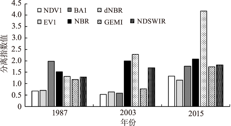
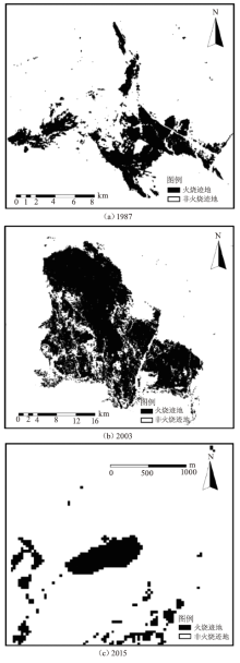
| [1] |
安森鹏, 高振岭, 王磊. 林火对森林生态系统的影响[J]. 科技信息, 2013(6):90-91.
|
| [2] |
杨伟, 张树文, 姜晓丽. 基于MODIS时序数据的黑龙江流域火烧迹地提取[J]. 生态学报, 2015, 35(17):5866-5873.
|
| [3] |
Mouillot F, Schultz M G, Yue C, et al. Ten years of global burned area products from spaceborne remote sensing—A review:Analysis of user needs and recommendations for future developments[J]. International Journal of Applied Earth Observations and Geoinformation, 2014, 26:64-79.
|
| [4] |
钱峻屏, 李岩, 廖其芳, 等. 利用遥感植被指数分析中国东部样带农业生态系统的生产力格局[J]. 生态学杂志, 2001(6):46-49.
|
| [5] |
孙桂芬, 覃先林, 刘树超, 等. 典型植被指数识别火烧迹地潜力分析[J]. 国土资源遥感, 2019, 31(1):204-211.
|
| [6] |
Key C H. Ecological and sampling constraints on defining landscape fire severity[J]. Fire Ecology, 2006, 2(2):34-59.
doi: 10.4996/fireecology.0202034
|
| [7] |
Roy D P, Jin Y, Lewis P E, et al. Prototyping a global algorithm for systematic fire-affected area mapping using MODIS time series data[J]. Remote Sensing of Environment, 2005, 97(2):137-162.
doi: 10.1016/j.rse.2005.04.007
|
| [8] |
孙桂芬. 森林火烧迹地识别及植被恢复卫星遥感监测方法[D]. 北京: 中国林业科学研究院, 2018.
|
| [9] |
朱曦, 覃先林. 基于二阶段算法的HJ-CCD数据过火区制图[J]. 遥感技术与应用, 2013, 28(1):72-77.
|
| [10] |
吴立叶, 沈润平, 李鑫慧, 等. 不同遥感指数提取林火迹地研究[J]. 遥感技术与应用, 2014, 29(4):567-574.
|
| [11] |
祖笑锋, 覃先林, 尹凌宇, 等. 基于高分一号影像光谱指数识别火烧迹地的决策树方法[J]. 林业资源管理, 2015(4):73-78.
|
| [12] |
康祥瑞. 基于Landsat TM影像的火烧迹地遥感提取及林火烈度的空间分析[D]. 哈尔滨: 东北林业大学, 2017.
|
| [13] |
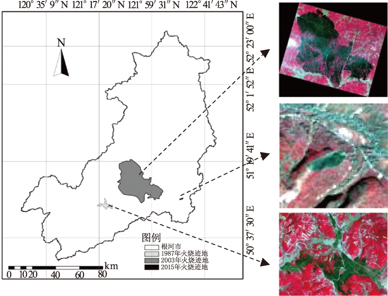
包月梅, 孙紫英, 赵鹏武, 等. 基于遥感数据的根河市火烧迹地植被覆盖度时空分析[J]. 东北林业大学学报, 2015, 43(11):62-69.
|
| [14] |
罗火钱, 陈文惠. 火烧迹地森林恢复的植被指数时间序列特征谱研究[J]. 四川林勘设计, 2012(1):23-30.
|
| [15] |
余哲修, 何超, 李昔纯, 等. 基于归一化燃烧率火烧迹地遥感提取识别规则研究[J]. 西北林学院学报, 2018, 33(1):216-224.
|
| [16] |
王晓莉, 王文娟, 常禹, 等. 基于NBR指数分析大兴安岭呼中森林过火区的林火烈度[J]. 应用生态学报, 2013, 24(4):967-974.
|
| [17] |
Veraverbeke S, Harris S, Hook S. Evaluating spectral indices for burned area discrimination using MODIS/ASTER(MASTER)airborne simulator data[J]. Remote Sensing of Environment, 2011, 115(10):2702-2709.
doi: 10.1016/j.rse.2011.06.010
|
| [18] |
Loboda T, O'Neal K J, Csiszar I. Regionally adaptable dNBR-based algorithm for burned area mapping from MODIS data[J]. Remote Sensing of Environment, 2007, 109(4):429-442.
doi: 10.1016/j.rse.2007.01.017
|
| [19] |
Bastarrika A, Chuvieco E, Martín M P. Mapping burned areas from Landsat TM/ETM+data with a two-phase algorithm:Balancing omission and commission errors[J]. Remote Sensing of Environment, 2010, 115(4):1003-1012.
doi: 10.1016/j.rse.2010.12.005
|
| [20] |
钱安, 陈娅男, 王秋玲. 基于Landsat影像提取大兴安岭区域火烧迹地[J]. 山西建筑, 2017, 43(15):192-193.
|
| [21] |
Gitas I Z, Devereux B J. The role of topographic correction in mapping recently burned Mediterranean forest areas from LANDSAT TM images[J]. International Journal of Remote Sensing, 2006, 27(1):41-54.
doi: 10.1080/01431160500182992
|
 ), WANG Xing1, ZHANG Qiuliang1,2, WANG Bing1,2(