

FOREST RESOURCES WANAGEMENT ›› 2020, Vol. 0 ›› Issue (6): 135-142.doi: 10.13466/j.cnki.lyzygl.2020.06.022
• Technical Application • Previous Articles Next Articles
SUN Zhongqiu1( ), WU Fayun1(), HU Yang2, GAO Xianlian1, Gao Jingping1
Received:2020-09-24
Revised:2020-11-06
Online:2020-12-28
Published:2021-01-26
Contact:
WU Fayun
E-mail:qiuqiu8708@163.com;wufayun@sina.com
CLC Number:
SUN Zhongqiu, WU Fayun, HU Yang, GAO Xianlian, Gao Jingping. Determination and Estimation of Pinus massoniana Stand Volume and Saturation Point Based on Landsat-8 OLI Data[J]. FOREST RESOURCES WANAGEMENT, 2020, 0(6): 135-142.
Add to citation manager EndNote|Ris|BibTeX
URL: http://www.lyzygl.com.cn/EN/10.13466/j.cnki.lyzygl.2020.06.022
Tab.1
Sample stand data statistics
| 类别 | 最小值/(m3/hm2) | 最大值/(m3/hm2) | 平均/(m3/hm2) | 标准误差/(m3/hm2) | 方差/(m3/hm2) | 观测数/个 |
|---|---|---|---|---|---|---|
| 总样本 | 4.25 | 318.47 | 125.36 | 9.31 | 6234.29 | 72 |
| 建模样本 | 5.66 | 318.47 | 117.01 | 10.73 | 5871.01 | 51 |
| 验证样本 | 4.25 | 309.98 | 145.65 | 18.05 | 6843.92 | 21 |
Tab.2
Band information of Landsat-8 OLI
| 波段 | 波段名称 | 波长范围/μm | 空间分辨率/m |
|---|---|---|---|
| B2 | Blue | 0.452~0.512 | 30 |
| B3 | Green | 0.533~0.590 | 30 |
| B4 | Red | 0.636~0.673 | 30 |
| B5 | NIR | 0.851~0.879 | 30 |
| B6 | SWIR1 | 1.566~1.651 | 30 |
| B7 | SWIR2 | 2.107~2.294 | 30 |
Tab.3
Correlation analysis of band variables
| FSV | B2 | B3 | B4 | B5 | B6 | B7 | |
|---|---|---|---|---|---|---|---|
| FSV | 1 | ||||||
| B2 | -0.515** | 1 | |||||
| B3 | -0.625** | 0.919** | 1 | ||||
| B4 | -0.559** | 0.939** | 0.948** | 1 | |||
| B5 | -0.388** | 0.511** | 0.685** | 0.501** | 1 | ||
| B6 | -0.545** | 0.835** | 0.914** | 0.839** | 0.835** | 1 | |
| B7 | -0.567** | 0.924** | 0.937** | 0.956** | 0.621** | 0.934** | 1 |
Tab.4
Model estimation parameters
| 参数 | 球状模型 | 二项式模型 | |||
|---|---|---|---|---|---|
| 估计 | 标准误 | 估计 | 标准误 | ||
| a0 | 723.105 | 25.051 | 756.247 | 27.216 | |
| a1 | -2.085 | 0.278 | -3.149 | 0.430 | |
| a2 | 1.475E-05 | 0.000 | 0.008 | 0.001 | |

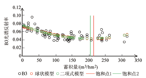
Fig.1
Determination of the stock volume saturation point based on B3
Tab.5
Correlation analysis of Vegetation Index
| FSV | DVI | RDVI | EVI | NDVI | GNDVI | LAI | RVI | |
|---|---|---|---|---|---|---|---|---|
| FSV | 1 | |||||||
| DVI | -0.279* | 1 | ||||||
| RDVI | -0.110 | 0.944** | 1 | |||||
| EVI | -0.224 | 0.984** | 0.966** | 1 | ||||
| NDVI | 0.408** | 0.261* | 0.560** | 0.360** | 1 | |||
| GNDVI | 0.451** | 0.306** | 0.583** | 0.389** | 0.952** | 1 | ||
| LAI | -0.224 | 0.984** | 0.966** | 1.000** | 0.360** | 0.389** | 1 | |
| RVI | 0.365** | 0.290* | 0.577** | 0.382** | 0.974** | 0.946** | 0.382** | 1 |
Tab.6
Model estimation parameters
| 参数 | 球状模型 | 二项式模型 | |||
|---|---|---|---|---|---|
| 估计 | 标准误 | 估计 | 标准误 | ||
| a0 | 631.329 | 9.713 | 618.756 | 10.586 | |
| a1 | 0.672 | 0.108 | 1.080 | 0.167 | |
| a2 | -5.772E-06 | 0.000 | -0.003 | 0.001 | |

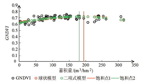
Fig.2
Determination of the stock volume saturation point based on GNDVI
Tab.7
Results of multiple linear stepwise regression model
| 波段 | 估计值 | 标准误差 | T值 | P值 |
|---|---|---|---|---|
| 截距 | 339.85 | 39.48 | 8.609 | 2.69e-11*** |
| B2 | 5259.76 | 1852.41 | 2.839 | 0.00661** |
| B3 | -7195.29 | 1441.5 | -4.992 | 8.30e-06*** |

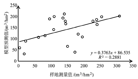
Fig.3
Validation results of multiple linear stepwise regression model
Tab.8
Estimation of binomial model accumulations
| 参数 | 估计 | 标准误 |
|---|---|---|
| b0 | 405.540 | 152.546 |
| b1 | -6739.733 | 5098.382 |
| b2 | 25672.062 | 41152.060 |

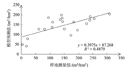
Fig.4
Binomial model validation results
| [1] | 毛学刚, 姚瑶, 范文义. 基于Landsat长时间序列的森林扰动参数提取与树高估算[J]. 林业科学, 2019,55(3):79-87. |
| [2] | 周小成, 何艺, 黄洪宇, 等. 基于两期无人机影像的针叶林伐区蓄积量估算[J]. 林业科学, 2019,55(11):117-125. |
| [3] | 韩宗涛, 江洪, 王威, 等. 基于多源遥感的森林地上生物量KNN-FIFS估测[J]. 林业科学, 2018,54(9):70-79. |
| [4] | 庞勇, 蒙诗栎, 李增元. 机载高分辨率遥感影像的傅氏纹理因子估测温带森林地上生物量[J]. 林业科学, 2017,53(3):94-104. |
| [5] | 严恩萍, 赵运林, 林辉, 等. 基于地统计学和多源遥感数据的森林碳密度估算[J]. 林业科学, 2017,53(7):72-84. |
| [6] | 祖笑锋, 覃先林, 李增元, 等. 基于幂律分布的森林燃烧生物量卫星遥感估测方法[J]. 林业科学, 2017,53(10):90-99. |
| [7] |
郭云, 李增元, 陈尔学, 等. 甘肃黑河流域上游森林地上生物量的多光谱遥感估测[J]. 林业科学, 2015,51(1):140-149.
doi: 10.11707/j.1001-7488.20150117 |
| [8] |
戚玉娇, 李凤日. 基于KNN方法的大兴安岭地区森林地上碳储量遥感估算[J]. 林业科学, 2015,51(5):46-55.
doi: 10.11707/j.1001-7488.20150506 |
| [9] |
李亦秋, 冯仲科, 邓欧, 等. 基于3S技术的山东省森林蓄积量估测[J]. 林业科学, 2009(9):85-93.
doi: 10.11707/j.1001-7488.20090915 |
| [10] |
Chrysafis I, Mallinis G, Tsakiri M, et al. Evaluation of single-date and multi-seasonal spatial and spectral information of Sentinel-2 imagery to assess growing stock volume of a Mediterranean forest[J]. International Journal of Applied Earth Observation and Geoinformation, 2019,77:1.
doi: 10.1016/j.jag.2018.12.004 |
| [11] |
Hu Y, Xu X, Wu F, et al. Estimating Forest Stock Volume in Hunan Province,China,by Integrating In Situ Plot Data,Sentinel-2 Images,and Linear and Machine Learning Regression Models[J]. Remote Sensing, 2020,12(1):186.
doi: 10.3390/rs12010186 |
| [12] |
Mura M, Bottalico F, Giannetti F, et al. Exploiting the capabilities of the Sentinel-2 multi spectral instrument for predicting growing stock volume in forest ecosystems[J]. International Journal of Applied Earth Observation and Geoinformation, 2018,66:126.
doi: 10.1016/j.jag.2017.11.013 |
| [13] | Redowan M, Akter R, Islam M, et al. Estimating growing stock volume in a Bangladesh forest site using landsat TM and field-measured data[J]. International Journal of Geomatics and Geosciences, 2015,6(2):1607-1619. |
| [14] |
Tokola T. The Influence of field sample data location on growing stock volume estimation in landsat TM-based forest inventory in Eastern finland[J]. Remote Sensing of Environment, 2000,74(3):422-431.
doi: 10.1016/S0034-4257(00)00135-8 |
| [15] |
Zheng S, Cao C, Dang Y, et al. Retrieval of forest growing stock volume by two different methods using Landsat TM images[J]. International Journal of Remote Sensing, 2014,35(1):29-43.
doi: 10.1080/01431161.2013.860567 |
| [16] | 王原. 湖南省森林资源保护策略研究[D]. 长沙:中南林业科技大学, 2019. |
| [17] | 杨立岩. 多平台多源遥感测树因子提取技术与方法研究[D]. 北京:北京林业大学, 2018. |
| [18] | 赵盼盼. 基于Landsat TM和ALOS PALSAR数据的森林地上生物量估测研究[D]. 杭州:浙江农林大学, 2016. |
| [19] | 张彦林. Box-Cox变换在遥感数据建模中的应用[J]. 东北林业大学学报, 2010,38(8):120-122. |
| [20] | 周洪泽, 曲智林. 连续森林清查应用地理信息估计蓄积量的方法[J]. 东北林业大学学报, 2000,28(5):50-53. |
| [21] | 张秋江, 袁亚东. 用遥感及实测回归估计森林蓄积量[J]. 东北林业大学学报, 1997,25(2):18-23. |
| [22] |
Huang W, Swatantran A, Duncanson L, et al. County-scale biomass map comparison:a case study for Sonoma,California[J]. Carbon Management, 2017,8(5-6):417-434.
doi: 10.1080/17583004.2017.1396840 |
| [23] |
Wang J, Xiao X, Bajgain R, et al. Estimating leaf area index and aboveground biomass of grazing pastures using Sentinel-1,Sentinel-2 and Landsat images[J]. ISPRS Journal of Photogrammetry and Remote Sensing, 2019,154:189-201.
doi: 10.1016/j.isprsjprs.2019.06.007 |
| [24] |
Xia H, Zhao W, Li A, et al. Subpixel Inundation Mapping Using Landsat-8 OLI and UAV Data for a Wetland Region on the Zoige Plateau,China[J]. Remote Sensing, 2017,9(1):31.
doi: 10.3390/rs9010031 |
| Viewed | ||||||
|
Full text |
|
|||||
|
Abstract |
|
|||||