

FOREST RESOURCES WANAGEMENT ›› 2020, Vol. 0 ›› Issue (6): 54-60.doi: 10.13466/j.cnki.lyzygl.2020.06.009
• Scientific Research • Previous Articles Next Articles
JIANG Yongquan( ), SHI Zhengtao(), GAO Shupeng
Received:2020-09-30
Revised:2020-10-26
Online:2020-12-28
Published:2021-01-26
Contact:
SHI Zhengtao
E-mail:jiangyongquan1108@163.com;shizhengtao@163.com
CLC Number:
JIANG Yongquan, SHI Zhengtao, GAO Shupeng. Research on Rubber Plantation Identification and Suitable Areas Based on Multi-source Remote Sensing Data[J]. FOREST RESOURCES WANAGEMENT, 2020, 0(6): 54-60.
Add to citation manager EndNote|Ris|BibTeX
URL: http://www.lyzygl.com.cn/EN/10.13466/j.cnki.lyzygl.2020.06.009
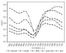
Fig.1
NDVI time series curve diagram of ground species

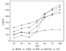
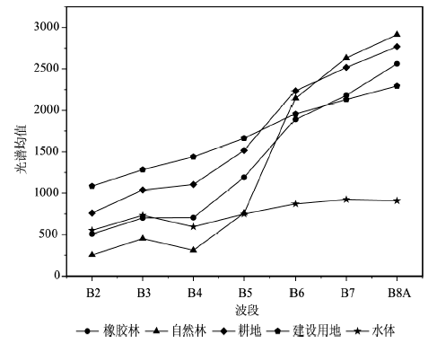
Fig.2
Curve of mean value of spectral reflectance of ground species
Tab.1
Features of ground features classification
| 特征描述 | Sentinel-2 特征个数 | MOD13Q1 特征个数 | ||||
|---|---|---|---|---|---|---|
| 光谱 特征 | 光谱 反射率 | 植被红边波段1,B5 植被红边波段4,B8A | 1 1 | — | ||
| 植被指数 | NDVI指数 | 1 | 23 | |||
| 均值 | 4 | |||||
| 纹理 特征 | 灰度共 生矩阵 | 同质性 相关性 熵 对比度 | 4 4 4 4 | — | ||

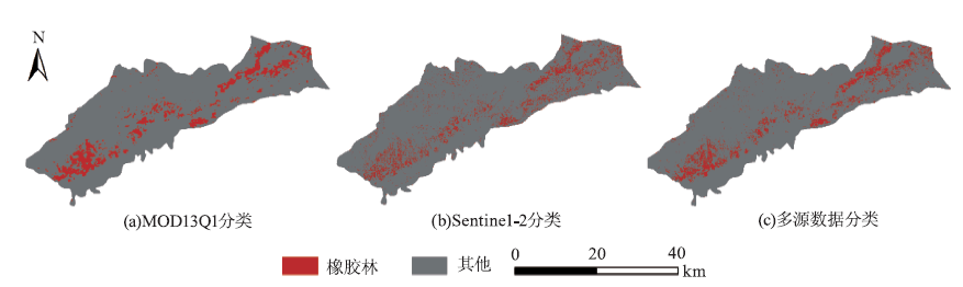
Fig.3
Result of rubber forest identification
Tab.2
Comparison table of rubber forest identification accuracy evaluation
| 数据源 | 橡胶林/% | 其他/% | PA/UA | OA/% | Kappa系数 |
|---|---|---|---|---|---|
| MOD13Q1-NDVI数据 | 71.48 | 88.89 | PA | 85.31 | 0.57 |
| 62.46 | 92.34 | UA | |||
| Sentinel-2数据 | 73.00 | 92.13 | PA | 88.20 | 0.64 |
| 70.59 | 92.96 | UA | |||
| 多源数据 | 89.73 | 91.84 | PA | 91.41 | 0.76 |
| 73.98 | 97.19 | UA |
Tab.3
Distribution characteristics of rubber forest in Ruili City at altitude
| 海拔/m | 面积/hm2 | 所占比例/% |
|---|---|---|
| 682~ 900 | 6433.11 | 83.61 |
| 900~1100 | 1174.23 | 15.26 |
| 1000~1200 | 86.49 | 1.12 |
| 1200~1300 | 0 | 0 |
| 1300~1400 | 0 | 0 |
| ≥1400 | 0 | 0 |
| 合计 | 7693.83 | 100.00 |
Tab.4
The distribution characteristics of the rubber forest in Ruili City on the slope
| 坡度/(°) | 面积/hm2 | 所占比例/% |
|---|---|---|
| 0~ 5 | 439.11 | 5.71 |
| 5~ 8 | 3818.61 | 49.63 |
| 8~15 | 2691.63 | 34.98 |
| 15~25 | 660.33 | 8.58 |
| 25~35 | 84.15 | 1.09 |
| ≥35 | 0 | 0 |
| 合计 | 7693.83 | 100.00 |

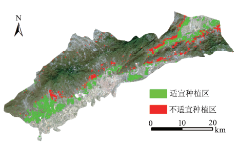
Fig.4
Suitable areas for rubber plantation in Ruili City
| [1] | 杜香玉. 从战略资源到生态系统遭受破坏——对20世纪以来橡胶引种的认知与反思[J]. 原生态民族文化学刊, 2020,12(1):10-20. |
| [2] | 何康, 黄宗道. 热带北缘橡胶树栽培[M]. 广州: 广东科技出版社, 1987. |
| [3] | 付如作. 瑞丽市橡胶产业发展现状及对策研究[J]. 农业与技术, 2017,37(5):145-147. |
| [4] | Li H, Aide T M, Ma Y, et al. Demand for rubber is causing the loss of high diversity rain forest in SW China[M]// Plant Conservation and Biodiversity.Dordrecht:Springer, 2006: 157-171. |
| [5] | 陈汇林, 陈小敏, 陈珍丽, 等. 基于MODIS遥感数据提取海南橡胶信息初步研究[J]. 热带作物学报, 2010,31(7):1181-1185. |
| [6] | Senf C, Pflugmacher D, Van der Linden S, et al. Mapping rubber plantations and natural forests in Xishuangbanna(Southwest China) using multi-spectral phenological metrics from MODIS time series[J]. Remote Sensing, 2013,5(6):2795-2812. |
| [7] | 高书鹏, 史正涛, 刘晓龙, 等. 基于高时空分辨率可见光遥感数据的热带山地橡胶林识别[J]. 遥感技术与应用, 2018,33(6):1122-1131. |
| [8] | Chen Bangqian, Li Xiangping, Xiao Xiangming, et al. Mapping tropical forests and deciduous rubber plantations in Hainan Island,China by integrating PALSAR 25-m and multi-temporal Landsat images[J]. International journal of applied earth observation and geoinformation, 2016,50:117-130. |
| [9] | Kou Weili, Xiao Xiangming, Dong Jinwei, et al. Mapping deciduous rubber plantation areas and stand ages with PALSAR and Landsat images[J]. Remote Sensing, 2015,7(1):1048-1073. |
| [10] |
Pohl C Van Genderen J L. Review article multisensor image fusion in remote sensing:concepts,methods and applications[J]. International journal of remote sensing, 1998,19(5):823-854.
doi: 10.1080/014311698215748 |
| [11] | 黄艳, 廖玲. 云研77-2和77-4橡胶树新品种区域性栽培试验初报[J]. 中国热带农业, 2009(2):38-40. |
| [12] | 江爱良. 云南南部、西南部生态气候和橡胶树的引种[J]. 中国农业气象, 1995(5):26-31. |
| [13] | 吴俊. 云南橡胶树气候生态适应性分析[J]. 现代农业科技, 2011(19):308-309. |
| [14] | 德宏州农垦分局. 德宏垦区1982/83年冬期橡胶树寒害调查报告[J]. 云南热作科技, 1984(2):4-8. |
| [15] | 付如作. 瑞丽市橡胶产业发展现状及对策研究[J]. 农业与技术, 2017,37(5):145-147. |
| [16] | 祁栋灵, 王秀全, 左雪冬. 宣贯橡胶树栽培和割胶技术规程提升植胶业科技水平[J]. 热带农业科学, 2008,28(5):50-54. |
| [17] | 康靖. 浅论瑞丽市热带天然林停伐后的保护问题[J]. 农村实用技术, 2020(5):123-124. |
| [18] | 董丽芳, 杨军, 杨涛, 等. 瑞丽市橡胶产业发展现状及对策[J]. 云南农业, 2018(8):42-45. |
| [19] | 陈柳嫱, 刘杰, 杨雯雯. 森林培育对瑞丽市生态环境建设的影响[J]. 绿色科技, 2019(8):128-129. |
| [20] | 尹啟令, 李仕娇, 雷荣华, 等. 瑞丽地区橡胶幼林套种百香果初探[J]. 热带农业科技, 2019,42(4):29-31. |
| [21] | Main-Knorn M, Pflug B, Louis J, et al. Calibration and validation plan for the L2A processor and products of the Sentinel-2 mission[C]// Proceedings of International Symposium on Remote Sensing of Environment.36th International Symposium on Remote Sensing of Environment(ISRSE), 2015. |
| [22] | Emde C, Buras-Schnell R, Kylling A, et al. The libRadtran software package for radiative transfer calculations(version 2.0.1)[J]. Geoscientific Model Development, 2016,9(5):1647-1672. |
| [23] | 罗媛, 谢堂民, 龙显静, 等. 基于红光和近红外反射光谱特征参数反演草地地上生物量[J]. 草原与草坪, 2015,35(5):65-69. |
| [24] | Tucker C J. Red and photographic infrared linear combinations for monitoring vegetation[J]. Remote sensing of Environment, 1979,8(2):127-150. |
| [25] | Haralick R M, Shanmugam K, Dinstein I H. Textural features for image classification[J]. IEEE Trans.SMC, 1973(6):610-621. |
| [26] | 陈强, 田杰, 黄海宁, 等. 基于统计和纹理特征的SAS图像SVM分割研究[J]. 仪器仪表学报, 2013,34(6):214-221. |
| [27] | SL 190-2007,土壤侵蚀分类分级标准[S]. |
| [28] | NY/T221-2016,橡胶树栽培技术规程[S]. |
| [1] | DUAN Jiwei, ZHONG Jiusheng, JIANG Li, DAI Renli, HE Zhiyuan, LIN Shuangshuang, HE Xin. Study on Vegetation Extraction Method in Karst Areas Based on Visible Light Band of Sentinel 2 [J]. FOREST RESOURCES WANAGEMENT, 2020, 0(6): 143-152. |
| [2] | CAI Linfei, WU Dasheng, FANG Luming, ZHENG Xinyu. Tree Species Identification Using XGBoost Based on GF-2 Images [J]. FOREST RESOURCES WANAGEMENT, 2019, 0(5): 44-51. |
| [3] | LIU Yang, XIAO Zhongqi, ZHANG Huaiqing, YAO Bo, HUANG Jianwen. Analysis on the Change of Forest Land Types in The Xinjiang Altai Mountain Natural Forest Protection Project Area from 2000 to 2016 [J]. FOREST RESOURCES WANAGEMENT, 2019, 0(1): 70-77. |
| [4] | ZHAO Xun, YUE Cairong. Study on Forest Change Detection Method Based on Remote Sensing Data [J]. FOREST RESOURCES WANAGEMENT, 2019, 0(1): 101-108. |
| [5] | MA Hua, WANG Yifei, NING Yu, WU Gaojie, GUO Julan, TAN Yuechen, LI Chunyi, LIN Haiyan. Dynamic Analysis of Landscape Pattern of the Plateau Wetland of Zoige County [J]. FOREST RESOURCES WANAGEMENT, 2019, 0(1): 109-115. |
| [6] | QIAO Zhengnian, MA Jun, XU Yannan. Application of UAV Remote Sensing in Measuring Canopy [J]. FOREST RESOURCES WANAGEMENT, 2019, 0(1): 78-84. |
| [7] | SU Bude, ZHAO Yangyi, WANG Keqin, DUAN Xu, FANG Bin. Changes of Soil Erosion in the Small Watershed of the Taqing River in Southern Yunnan Province in Recent 20 Years Based on GIS [J]. FOREST RESOURCES WANAGEMENT, 2018, 0(6): 90-98. |
| [8] | YANG Fan. Experiment and Analysis of Unmanned Aerial Vehicle Oblique Photography in Constructing 3D Model of Forest Scenic Spots [J]. FOREST RESOURCES WANAGEMENT, 2018, 0(4): 120-124. |
| [9] | LI Jie, ZHANG Jun, LIU Chenli, ZHANG Han. Study on Spatio-temporal Evolution of Vegetation Cover in the Nujiang River Basin of Yunnan Based on MODIS-NDVI Data [J]. FOREST RESOURCES WANAGEMENT, 2018, 0(4): 90-99. |
| [10] | YANG Yongtian, YANG Guangbin, ZHAO Haibin. Estimation of Forest Volume in Karst Mountain Ecosystem with Synthetic Aperture Radar Remote Sensing Technology [J]. FOREST RESOURCES WANAGEMENT, 2018, 0(4): 100-104. |
| [11] | WANG Yanfang, LIU Min, GUO Ying. Vegetation Dynamics and Sustainability in Ecological Supporting Areas of Hebei 1982—2015 [J]. FOREST RESOURCES WANAGEMENT, 2018, 0(1): 117-125. |
| [12] | SU Yanqin, LAI Riwen, LUO Wenwei, YU Lili, LAI Chimin, LI Honglin. Dynamic Change and Prediction of Land Use in Jinjiang City Based on LCM Model [J]. FOREST RESOURCES WANAGEMENT, 2018, 0(1): 96-102. |
| [13] | LIU Shuchao, CHEN Xiaozhong, QIN Xianlin, SUN Guifen, LI Xiaotong. Remote Sensing Assessment of Forest Fire Damage Degree in Bilahe Forest Farm,Inner Mongolia [J]. FOREST RESOURCES WANAGEMENT, 2018, 0(1): 90-95. |
| [14] | NIU Xiaohua, ZHANG Chao, YU Zhexiu, ZHOU Wenjiao, HUANG Tian. Analysis on Land Use Evolution Process in the Upper Reaches of Erhai under the Background of Urbanization [J]. FOREST RESOURCES WANAGEMENT, 2018, 0(1): 72-79. |
| [15] | WANG Cuiping. Analysis on Dynamic Change of Desertification Land and Driving Forces in the Middle Area of Kubuqi Desert [J]. FOREST RESOURCES WANAGEMENT, 2018, 0(1): 63-71. |
| Viewed | ||||||
|
Full text |
|
|||||
|
Abstract |
|
|||||