欢迎访问林业资源管理

林业资源管理 ›› 2022, Vol. 0 ›› Issue (4): 134-140.doi: 10.13466/j.cnki.lyzygl.2022.04.017

• 技术应用 • 上一篇    下一篇

基于哨兵2号多光谱遥感数据的草原植被盖度反演——以内蒙古自治区为例

田海静1,2(), 王林1,2(), 韩立亮1,2, 范云豹1,2, 杨吉林3   

  1. 1.国家林业和草原局林草调查规划院,北京 100714
    2.国家林业和草原局草原资源监测中心,北京 100714
    3.中国科学院地理科学与资源研究所,北京 100101
  • 收稿日期:2022-05-11 修回日期:2022-07-17 出版日期:2022-08-28 发布日期:2022-10-13
  • 通讯作者: 王林
  • 作者简介:田海静(1988-),女,河北保定人,高工,博士,主要从事草原遥感监测。Email: tianhaijing278@163.com

Grassland Vegetation Coverage Retrieval Based on Sentinel-2 Multi-Spectral Remote Sensing Data: A Case Study of Inner Mongolia Autonomous Region

TIAN Haijing1,2(), WANG Lin1,2(), HAN Liliang1,2, FAN Yunbao1,2, YANG Jilin3   

  1. 1. Academy of Forestry Inventory and Planning,National Forestry and Grassland Administration,Beijing 100714,China
    2. Grassland Monitoring Center,National Forestry and Grassland Administration,Beijing 100714,China
    3. Key Laboratory of Land Surface Pattern and Simulation,Institute of Geographic Sciences and Natural Resources Research,Chinese Academy of Sciences,Beijing 100101,China
  • Received:2022-05-11 Revised:2022-07-17 Online:2022-08-28 Published:2022-10-13
  • Contact: WANG Lin

摘要:

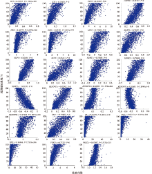
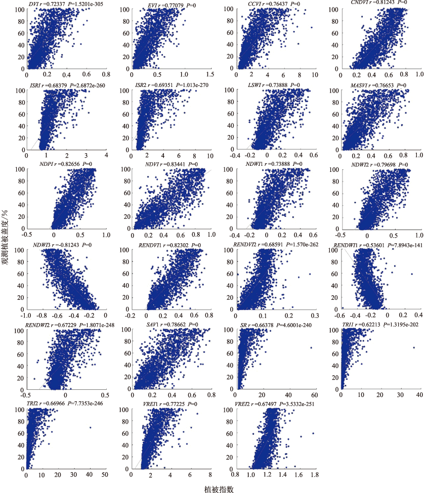
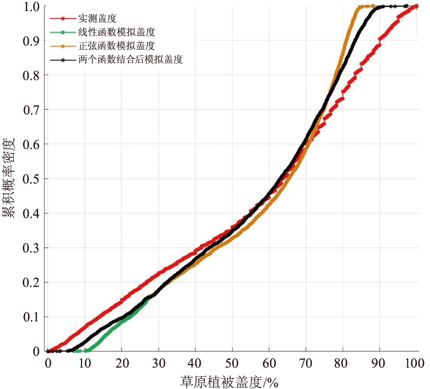
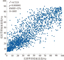
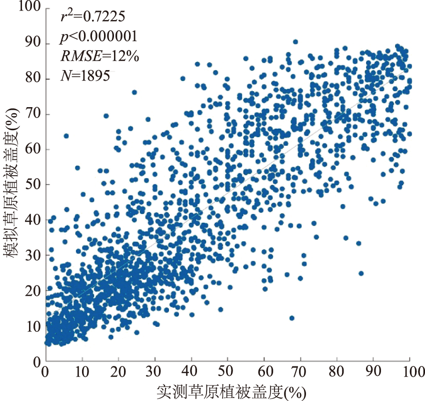
建立高精度草原植被盖度遥感估算模型对定量评估草原资源质量和支撑草原精细化管理至关重要。研究利用内蒙古自治区草原样地调查数据,基于哨兵2号多光谱遥感数据进行了草原植被盖度分类遥感建模及反演。研究表明:1)23种植被指数与实测植被盖度均呈现显著相关性(P<0.001),其中相关性最强的为NDVI,相关系数为0.834;2)正弦函数在高值部分(植被盖度>75%)的低估现象更明显,而线性函数在低值部分(植被盖度<25%)的高估现象更明显,通过采用两种函数对植被盖度进行分段模拟,结果较好;3)按照草地类分为6组分别进行植被盖度建模后,内蒙古自治区1 894个符合质量要求的样地模拟植被盖度与实测植被盖度的相关系数R2=0.722,显著性水平P<0.01,RMSE=12%;4)内蒙古自治区不同草地类植被盖度从高到低分别为山地草甸78.91%,温性草甸草原73.7%,低地草甸53.89%,温性草原52.57%,温性荒漠草原32.76%,温性草原化荒漠25.52%,温性荒漠19.29%。

关键词: 草原植被盖度, 分类建模, 遥感反演, 哨兵2号, 内蒙古自治区

Abstract:

High-precision grassland vegetation coverage remote sensing estimation model is important for quantitative assessment of grassland quality and fine management of grassland.Based on Sentinel-2 multi-spectral remote sensing data and measured sample plots in Inner Mongolia autonomous Region,grassland vegetation coverage was modeled and inverted.The results showed that:1)There was a significant correlation between the 23 vegetation indexes and the measured vegetation coverage (P<0.001),and the highest correlation coefficient was NDVI with a correlation coefficient of 0.834;2)The underestimation of sinusoidal function was more obvious in the high value part (coverage>75%),while the overestimation of linear function was more obvious in the low value part (coverage<25%),by using these two kinds of functions to simulate vegetation coverage,the results were better;3)The grassland types were divided into 6 groups to modeling vegetation coverage respectively.Finally,correlation coefficient between simulated and measured vegetation coverage for the 1 894 sample plots was R2=0.722,P<0.01,RMSE=12%;4)The vegetation coverage of different grassland types in Inner Mongolia from high to low was 78.91% for mountain meadow,73.7% for temperate meadow steppe,53.89% for lowland meadow,52.57% for temperate steppe,32.76% for temperate desert steppe,25.52% for temperate grassland desert and 19.29% for temperate desert.

Key words: grassland vegetation coverage, classification modeling, remote sensing inversion, Sentinel-2, Inner Mongolia Autonomous Region

中图分类号: