| [1] |
杨文静, 叶丹, 王姣, 等. 我国城镇化相关环境健康问题分析及对策研究[J]. 环境与健康杂志, 2017, 34(12):1053-1057.
|
| [2] |
申勇. 城市道路绿地景观设计研究[D]. 长沙: 中南林业科技大学, 2006.
|
| [3] |
张大敏. 城市道路景观的生态设计措施探讨[J]. 中国园林, 2013, 29(4):30-35.
|
| [4] |
张纯曦, 阿丽亚·拜都热拉, 占玉芳, 等. 城市不同功能区道路绿地对PM2.5和PM10的消减作用[J]. 山东农业大学学报:自然科学版, 2021, 52(6):949-954.
|
| [5] |
张丽丽, 董丽, 郝培尧, 等. 城市更新背景下的存量绿地植物景观设计策略思考[J]. 景观设计, 2022,(2):94-97.
|
| [6] |
王旭东. 城市绿地植物群落结构特征与优化调控研究[D]. 郑州: 河南农业大学, 2016.
|
| [7] |
李文琪. 生态服务功能视角下道路绿地优化设计研究[D]. 西安: 西安建筑科技大学, 2020.
|
| [8] |
王浩, 赵岩. 在城市中创建森林生态型景观路[J]. 南京林业大学学报, 2000(5):89-92.
|
| [9] |
刘洋. 基于LCA方法的城市绿地群落结构对管养环境影响的研究[D]. 郑州: 河南农业大学, 2018.
|
| [10] |
吴浩楠. 成都市道路绿带群落植物多样性及典型植物生理适应性研究[D]. 成都: 四川农业大学, 2020.
|
| [11] |
孙志勇. 天津市道路绿地植物多样性分析及优化对策研究[D]. 南京: 南京林业大学, 2012.
|
| [12] |
韦薇. 南京市城市道路绿地植物群落结构分析及景观优化研究[D]. 杭州: 浙江林学院, 2008.
|
| [13] |
李芳. 西安城市道路绿地耐旱型草本植物景观设计研究[D]. 西安: 西安建筑科技大学, 2021.
|
| [14] |
程文宇, 冯潇. 低空多旋翼无人机航测在风景园林规划设计前期现场观测中的应用[J]. 中国园林, 2018, 34(11):97-101.
|
| [15] |
韩炜杰, 王一岚, 郭巍. 无人机航测在风景园林中的应用研究[J]. 风景园林, 2019, 26(5):35-40.
|
| [16] |
仇巍巍, 陈从喜, 项家铀, 等. 三维GIS在国土空间规划中的应用综述[J]. 自然资源信息化, 2022(2):28-33.
|
| [17] |
贾智博, 刘雯雯, 慕彪彪, 等. 基于GIS的道路绿地数据库建设及应用——以兰州市为例[J]. 甘肃科技纵横, 2021, 50(7):10-13.
|
| [18] |
曹明兰, 张力小, 王强. 无人机遥感影像中行道树信息快速提取[J]. 中南林业科技大学学报, 2016, 36(10):89-93.
|
| [19] |
陈荻, 李卫正, 孔文丽, 等. 基于低空高分辨影像的三维绿量计算方法——以南京林业大学校园为例[J]. 中国园林, 2015, 31(9):22-26.
|
| [20] |
金星. 无人机航拍技术在风景园林规划设计中的应用[J]. 现代园艺, 2016(4):140.
|
| [21] |
李复, 常贺星. 无人机测量在景观设计科研与实践中的应用[J]. 景观设计学, 2019, 7(2):38-54.
|
| [22] |
谢栋博. 基于无人机可见光影像的城市公园树冠覆盖率和乔木多样性研究[D]. 郑州: 河南农业大学, 2022.
|
| [23] |
刘正威, 王腾飞, 靳焕, 等. 基于无人机倾斜摄影的山地景观规划——以新密市香山村为例[J]. 林业调查规划, 2020, 45(2):1-8.
|
| [24] |
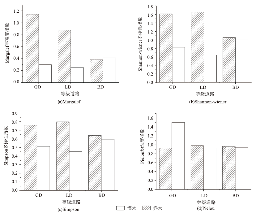
马克平. 生物群落多样性的测度方法Ⅰα多样性的测度方法(上)[J]. 生物多样性, 1994,(3):162-168.
doi: 10.17520/biods.1994027
|
| [25] |
马克平, 刘玉明. 生物群落多样性的测度方法Ⅰα多样性的测度方法(下)[J]. 生物多样性, 1994,(4):231-239.
doi: 10.17520/biods.1994038
|
| [26] |
何荣晓. 城市化对植物多样性的影响[D]. 海口: 海南大学, 2016.
|
| [27] |
杨瑞卿, 唐瓴, 谈海佳, 等. 无人机遥感技术在城市树木智慧化管理中的应用[J]. 中国城市林业, 2017, 15(6):29-32.
|
| [28] |
代婷婷, 马骏, 徐雁南. 基于Agisoft PhotoScan的无人机影像自动拼接在风景园林规划中的应用[J]. 南京林业大学学报:自然科学版, 2018, 42(4):165-170.
|
| [29] |
张璐, 项飞. 注重城市街区特征的道路绿化设计探讨——以永定门外东辅路绿化改造项目为例[J]. 中国园林, 2008(3):17-20.
|
| [30] |
费文君, 王浩. 城市道路绿地两侧绿带景观改造方法初探——以栾城县裕泰路为例[J]. 林业科技开发, 2012, 26(2):114-118.
|
| [31] |
王鹏飞, 栗燕, 杨秋生. 郑州市公园绿地木本植物物种多样性研究[J]. 中国园林, 2009, 25(5):84-87.
|
| [32] |
张智勇, 黄庆丰, 江国华. 宣城市道路绿化树种多样性研究[J]. 黄山学院学报, 2021, 23(5):65-68.
|
| [33] |
欧阳子珞, 吉文丽, 杨梅. 西安城市绿地植物多样性分析[J]. 西北林学院学报, 2015, 30(2):257-261,292.
|
| [34] |
战乃岩, 吕广, 李晓莉, 等. 灌木与乔木联合作用对街谷污染物分布影响[J]. 环境科学与技术, 2020, 43(6):101-107.
|
| [35] |
张静. 陕西省节约型乡土园林植物资源调查及其应用[J]. 中国农业资源与区划, 2018, 39(1):140-145.
|
 ), 王亚萍2, 李鑫洋2, 郭楠2, 杨玫2, 贺丹2(