欢迎访问林业资源管理

林业资源管理 ›› 2022, Vol. 0 ›› Issue (1): 114-123.doi: 10.13466/j.cnki.lyzygl.2022.01.014

• 技术应用 • 上一篇    下一篇

机载激光雷达树高产品的释义与精度水平评估

付安民(), 高显连(), 吴发云, 高金萍   

  1. 国家林业和草原局调查规划设计院,北京 100714
  • 收稿日期:2021-12-16 修回日期:2022-01-04 出版日期:2022-02-28 发布日期:2022-03-31
  • 通讯作者: 高显连
  • 作者简介:付安民(1980-),男,黑龙江富裕人,博士,主要从事林草行业遥感监测应用。Email: anmin_fu@163.com
  • 基金资助:
    北京空间机电研究所开放基金:陆地碳卫星多波束激光雷达载荷数据的林业应用能力研究(HT1060030)

A Method to Validate Airborne LIDAR CHM Producton Individual Tree Level

FU Anmin(), GAO Xianlian(), WU Fayun, GAO Jinping   

  1. Academy of Inventory and Planning,National Forestry and Grassland Administration,Beijing 100714,China
  • Received:2021-12-16 Revised:2022-01-04 Online:2022-02-28 Published:2022-03-31
  • Contact: GAO Xianlian

摘要:

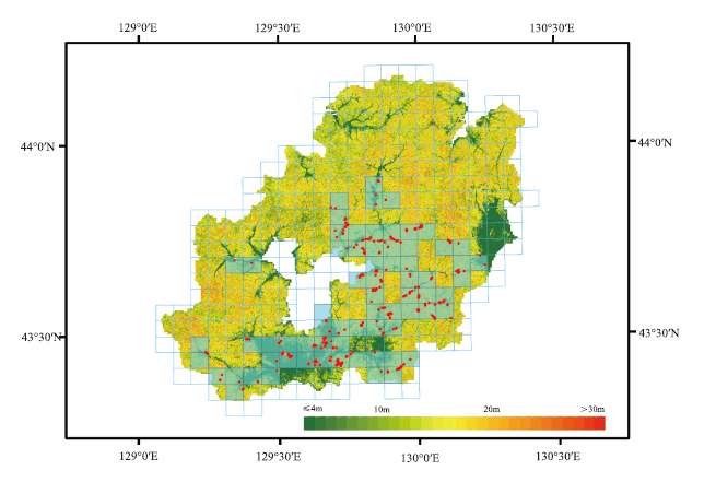
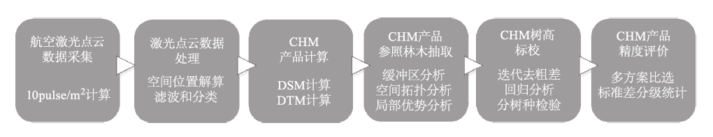
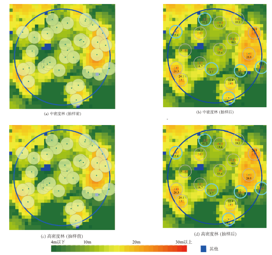
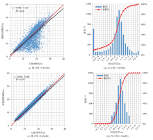
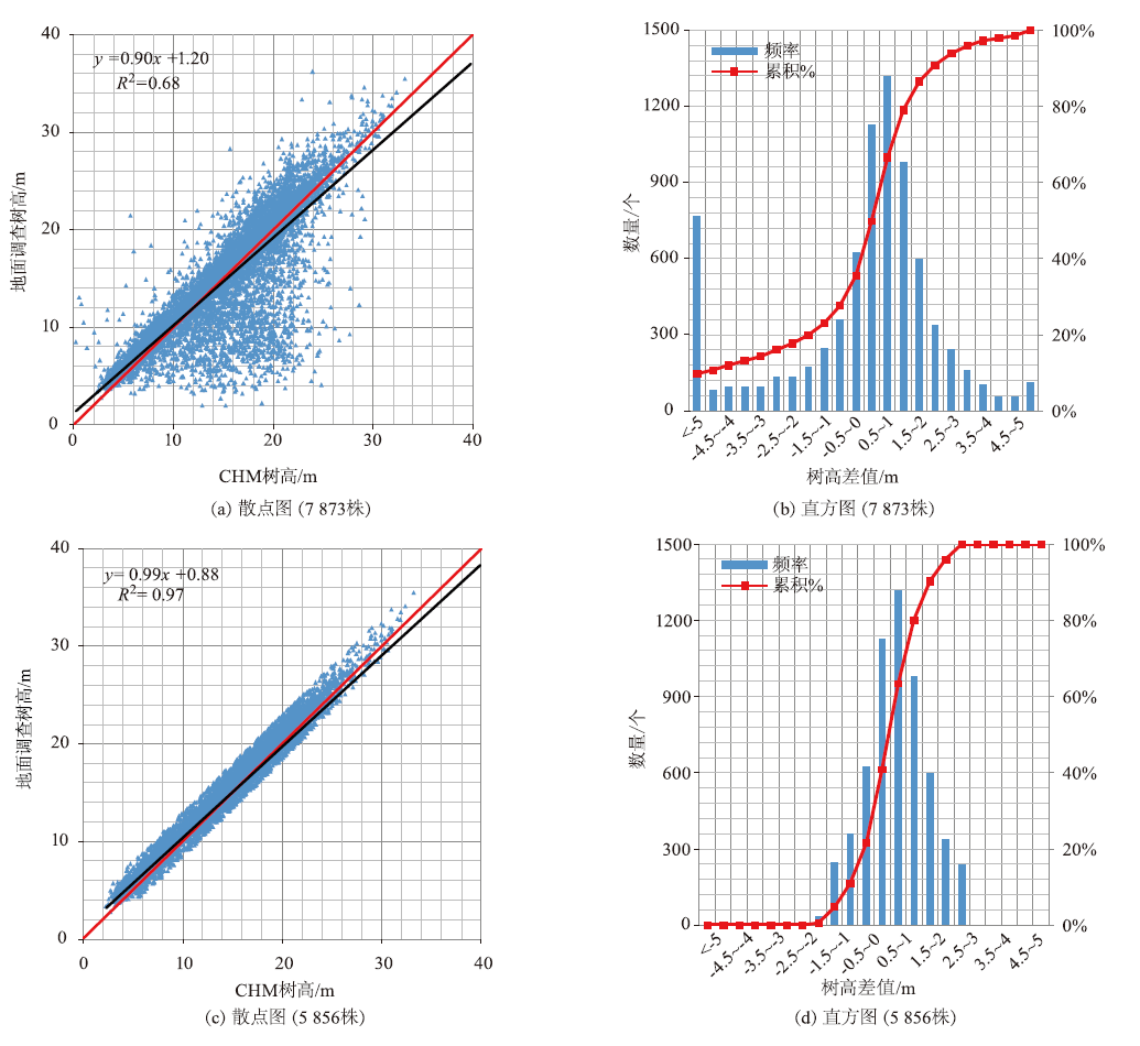
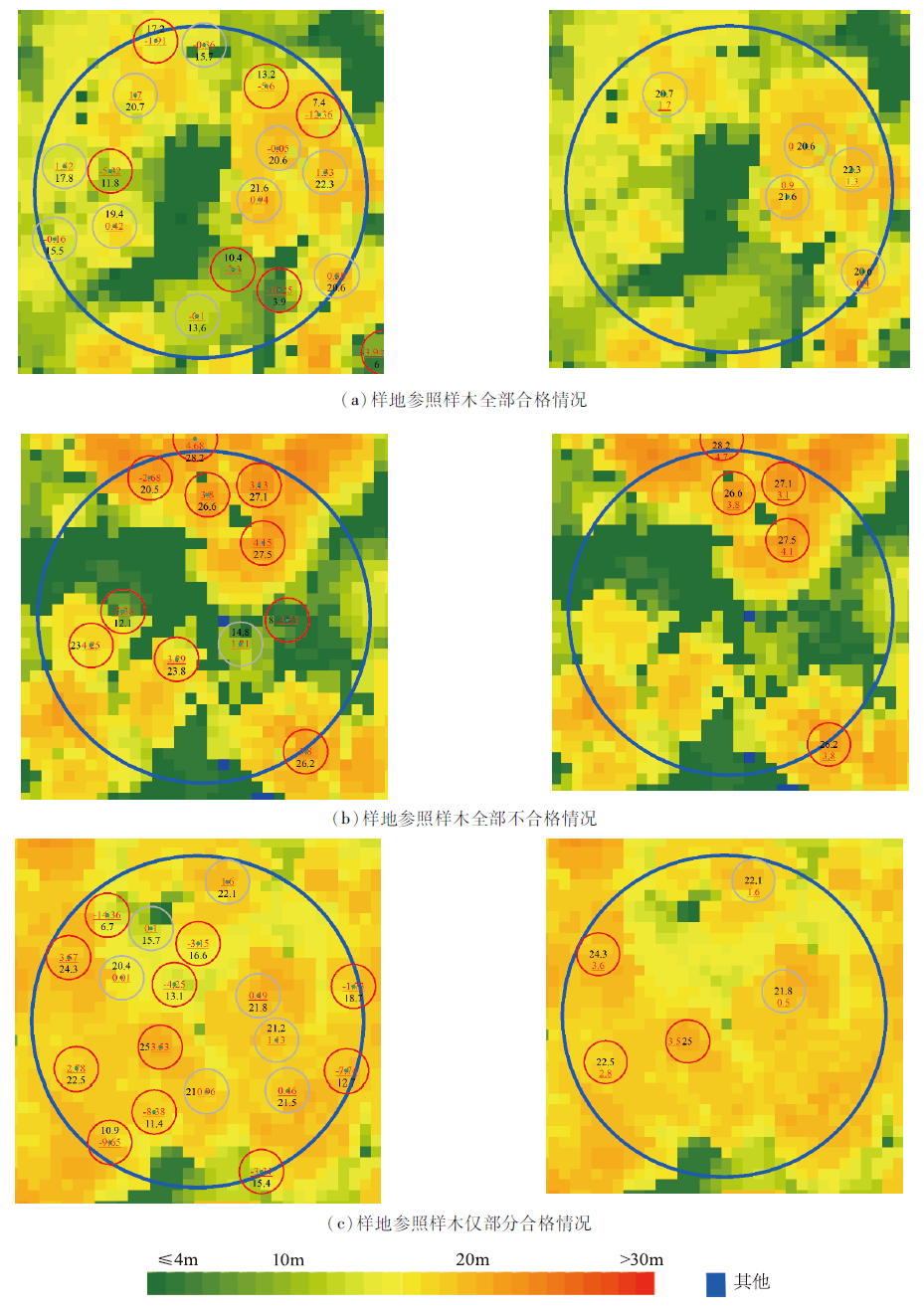
围绕航空激光雷达森林冠层高度产品(Canopy Height Model,CHM)的物理意义、准确性和精度指标,开展CHM产品质量评价的数据处理流程和技术方法研究,设计了地面参照样木筛选、迭代剔除粗差、分树种(组)相关性分析和精度水平等级分组统计等步骤。在我国东北虎豹国家公园开展了典型山地温带针阔混交森林的应用示范。对由航空激光测距设备RIEGL-VQ-1560i采集数据(激光脉冲密度10pluse/m2)并处理得到的CHM产品进行了精度评价,研究结果表明:1)从总体上看,CHM树高与“真实”树高具有极其显著的线性相关性,可达R2=0.97,CHM产品略低于“真实”树高,约为0.7m,具体到每株林木大致有±2m的不确定性;2)从各个树种(组)上看,各个树种(组)CHM树高与“真实”树高比较也均呈现略低现象,大小范围从0.3~1.3m不等,具体到每株林木大致有±1.4~±2.4m的不确定性,其中人工落叶松林的CHM高度比“真实”值低约1.3m,最为突出;3)从抽样参照林木精度水平等级分组统计结果情况上看,精度指标为0~±1m的CHM产品占比为57.6%,精度指标为0~±2m,CHM产品占比为79.4 %,其中,18.6%的抽样高度误差超过了+2m,仅有2.0%的抽样低于-2m,指明了产品大约1/5的区域存在CHM偏低的问题,需要进一步人工检验。研究结果表明,此技术方法可以有效地评价CHM产品整体质量状况及识别存在的问题,为大范围山地林区复杂作业条件下的航空激光雷达森林资源调查工程的质量控制提供了技术支撑和保障。

关键词: 树高, 森林资源监测, 机载激光雷达, 森林冠层高度产品CHM, CHM产品精度

Abstract:

The accuracy and precision of Airborne LIDAR canopy height model (CHM) product was accessedon in dividual tree level,using forest ground measurements with high-precision position. The analysis procedures were based on dominant trees sampling by spatial analysis tool,iterative elimination of outliers,correlation analysis,and rules for error grading statistics.The method was applied in Northeast Tiger and Leopard National Park. The CHM product was collected by LIDAR RIEGL-VQ-1560i with 10 pulse/m2. The results showed that: 1) CHM and "real" height had a significant linear correlation,R2=0.97;CHM products were slightly lower than the "real" height,about 0.7m;Roughly,there was an uncertainty of ±2m(2σ) for each tree;2) For each tree species (group),all CHMs were slightly lower than the "real" height too,ranging from 0.3m to 1.3m;Roughly,There was an uncertainty of ±1.4 ~±2.4m(2σ) for different species;Significantly,the CHM height of the larch was about 1.3m lower than the "real" value;3) the result of error grading statistics showed proportion of CHM with 0~ ±1m error was 57.6%; proportion of CHM with 0~±2m error was 79.4%;proportion of CHM with more than +2m error was 18.6%; proportion of CHM with less than -2m error was 2.0 %. It indicated that about 1/5 of the products had lower CHM values,which needed to be further explored. The results showed that the method could effectively identify the quality problems of CHM products,and provide a guarantee for the quality control of airborne LIDAR forest survey projects under complex operating conditions in large-scale and mountainous forest areas.

Key words: tree height, forestry resources monitoring, airborne LIDAR, canopy height model, CHM accuracy

中图分类号: