欢迎访问林业资源管理

林业资源管理 ›› 2021, Vol. 0 ›› Issue (2): 52-60.doi: 10.13466/j.cnki.lyzygl.2021.02.008

• 科学研究 • 上一篇    下一篇

全国林草资源调查机载大光斑激光雷达挂飞检校和验证

刘迎春1(), 高显连1(), 贺岩2, 崔晨彦1, 高剑新1, 俞家勇3, 蔡龙涛4, 吴发云1   

  1. 1.国家林业和草原局调查规划设计院,北京 100714
    2.中国科学院上海光学精密机械研究所,上海 201800
    3.安徽建筑大学,合肥 230601
    4.东北林业大学,哈尔滨 150040
  • 收稿日期:2021-02-09 修回日期:2021-04-08 出版日期:2021-04-28 发布日期:2021-06-03
  • 通讯作者: 高显连
  • 作者简介:刘迎春(1984-),男,山东枣庄人,高工,博士,主要从事激光雷达林业产品开发和应用工作。Email: liuyingchun2005@163.com
  • 基金资助:
    国家自然科学基金项目(31400426);国家林业和草原局行业管理专项(2130237);国家林业和草原局碳卫星海南试验站设备采购及集成项目(2130299)

Calibration and Validation of National Forest and Grassland Inventory Airborne Large-Footprint LiDAR

LIU Yingchun1(), GAO Xianlian1(), HE Yan2, CUI Chenyan1, GAO Jianxin1, YU Jiayong3, CAI Longtao4, WU Fayun1   

  1. 1. Academy of Inventory and Planning,National Forestry and Grassland Administration,Beijing 100714,China
    2. Shanghai Institute of Optics and Fine Mechanics,Chinese Academy of Sciences,Shanghai 201800,China
    3. Anhui Jianzhu University,Hefei 230601,China
    4. Northeast Forestry University,Harbin 150040,China
  • Received:2021-02-09 Revised:2021-04-08 Online:2021-04-28 Published:2021-06-03
  • Contact: GAO Xianlian

摘要:

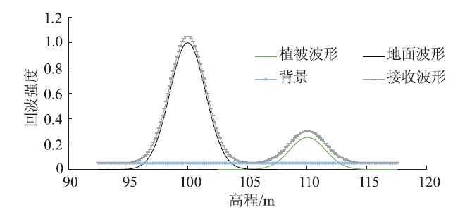
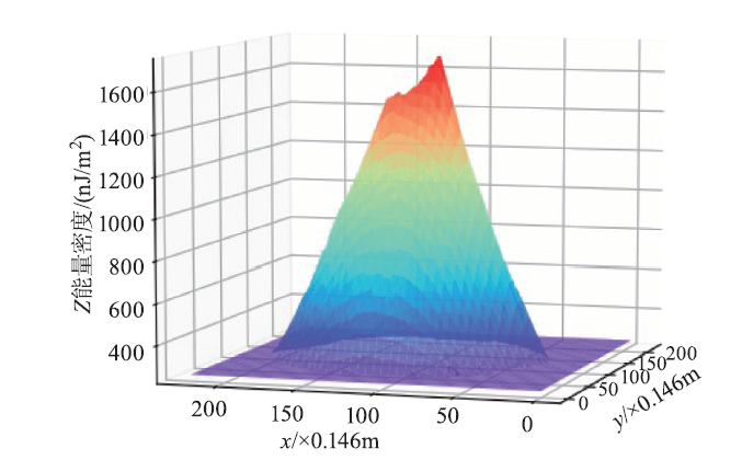
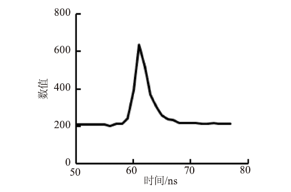
森林在全球陆地生态系统中起到重要作用,激光雷达是除样地调查之外能够准确评估其资源量和碳汇量非常重要的技术方法。由于森林高度的空间异质性,获得大光斑激光雷达的准确位置,是其应用于森林资源调查的前提。对新研制的全国林草资源调查机载大光斑激光雷达(NFGI-LIDAR-L)和地面激光探测器,通过编写大光斑激光雷达检校算法,并基于激光能量分布特征改进探测器法计算大光斑激光雷达中心位置算法,实现NFGI-LIDAR-L几何检校。结果显示:基于激光能量分布特征计算大光斑激光雷达中心位置的方法,计算精度从5m提升到1m以内;NFGI-LIDAR-L在x,y,z方向精度和总均方根误差(RMSE)从检校前的60.51,52.76,1.88,80.30m提高到检校后的0.61,0.54,0.05,0.82m,提升了2个数量级;与控制点相比,NFGI-LIDAR-L绝对高程精度在平坦地面可以达到0.12m。通过研究,以期对机载和星载大光斑激光雷达几何检校提供借鉴。

关键词: 全国林草资源调查机载大光斑激光雷达, 几何检校, 陆地生态系统碳监测卫星, 地面激光探测器, 空间分布

Abstract:

Forests play an important role in global terrestrial ecosystems.Precisely assessing forest resources and carbon sink with sample survey at a large scale is important before LiDAR is commonly used.To acquire precise geolocation of LiDAR footprint is an important step before it is applied in forest resource investigation because of the high special heterogeneity of forest height.In this paper,we use newly developed National Forest and Grassland Inventory Large-footprint LiDAR (NFGI-LIDAR-L)and ground Laser detector,develope a large-footprint LiDAR calibration method,improve the method of calculating the geocentric based on spatial pattern of laser from ground Laser detector,and calibrate NFGI-LIDAR-L.The results show that the method based on energy density of LiDAR improve the accuracy of calculating center location of large-footprint LiDAR from 5m to 1m.After calibration,the x,y,z and total accuracies of NFGI-LIDAR-L are improved from 60.51,52.76,1.88m and 80.30m to 0.61,0.54,0.05m and 0.82m,respectively.The absolute elevation accuracy of NFGI-LIDAR-L is 0.12m with flat surfaces validate with Ground Control Points.Therefore,the calibration method can be used in both calibration of airborne and spaceborne large-footprint LiDAR.

Key words: National Forest and Grassland Inventory Airborne Large-footprint LiDAR (NFGI-LIDAR-L), geometric calibration, Terrestrial Ecosystem Carbon Inventory Satellite, ground Laser detector, spatial pattern

中图分类号: