欢迎访问林业资源管理

林业资源管理 ›› 2017, Vol. 0 ›› Issue (1): 135-143.doi: 10.13466/j.cnki.lyzygl.2017.01.022

• 科学研究 • 上一篇    下一篇

喀斯特石漠化时空变化特征及驱动因子分析——以贵州晴隆县为例

史迎春1(), 舒英格2   

  1. 1. 贵州大学 资源与环境工程学院,贵阳 550025
    2. 贵州大学 农学院,贵阳 550025
  • 收稿日期:2016-12-28 修回日期:2017-01-13 出版日期:2017-02-28 发布日期:2020-10-03
  • 作者简介:史迎春(1990-),女,河南商丘人,在读硕士,研究方向:土地资源利用与保护。Email: 1508319804@qq.com
  • 基金资助:
    国家自然科学基金项目“喀斯特山区林草间作生态恢复过程中土壤质量演变规律及其评价——以贵州‘晴隆模式’为例”(31460133)

Analysis on Karst Rocky Desertification Temporal and Spatial Variation Characteristics and Driving Factors —A Case Study of Qinglong county of Guizhou Province

SHI Yingchun1(), SHU Yingge2   

  1. 1. College of Resources and Environmental Engineering,Guizhou University,Guiyang 550025,China
    2. College of Agriculture,Guizhou University,Guiyang,Guizhou 550025,China
  • Received:2016-12-28 Revised:2017-01-13 Online:2017-02-28 Published:2020-10-03

摘要:

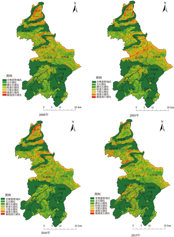
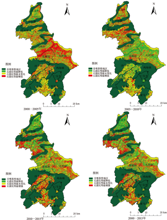
以晴隆县2000,2005,2010和2015年4期遥感影像资料为研究数据,利用综合指数法提取晴隆县无明显石漠化、潜在石漠化、轻度石漠化、中度石漠化、强度石漠化和极强度石漠化6个等级的石漠化分布图,利用石漠化时空动态模型,分析了研究区15年来石漠化在时间和空间上的变化特征;采用主成分分析法,确定了石漠化各驱动因子的权重。结果表明:在时间上,从2000—2015年,极强度石漠化、强度石漠化和中度石漠化面积大幅度减少;无明显石漠化、潜在石漠化和轻度石漠化均呈增加趋势。无明显石漠化、中度石漠化及强度石漠化,石漠化动态度变化较为明显;综合石漠化动态度变化幅度均较小,呈减小趋势。在空间上,石漠化等级增强的区域主要发生在花贡镇和大田乡,而石漠化等级降低的区域相对较多,主要分布在长流乡、中营镇、马场乡。2000—2015年,石漠化不断发生变化是自然环境和人类活动共同作用的结果,其中地类面积变化和人口对石漠化变化的影响最为显著,石漠化面积变化的驱动因子主要包括:人口、森林覆盖率、林地面积、耕地面积、农民人均纯收入、草地面积、GDP。研究结果以期能为晴隆县石漠化区生态治理工作与土地可持续利用提供参考。

关键词: 石漠化, 综合指数法, 时空变化, 驱动因子, 主成分分析法, 晴隆县

Abstract:

Based on remote sensing image of Qinglong County in 2000,2005,2010 and 2015 as the research data,comprehensive index method was used to obtain six grades of rocky desertification,such as no obvious rocky desertification,potential rocky desertification,slight rocky desertification,moderate rocky desertification,intense rocky desertification and extreme intense rocky desertification and the map of rocky desertification classification was extracted.Spatial-temporal dynamic model of rocky desertification was used variation characteristics of rocky desertification in time and space in the past 15 years in the study area analyzed,the principal component analysis method employed and the weight of each driving factor of rocky desertification determined.The result shows that from 2000 to 2015,in time,the extreme intense rocky desertification,intense rocky desertification and moderate rocky desertification area are sharply decreased;no obvious rocky desertification,potential rocky desertification and slight rocky desertification appeared as an increasing trend.No obvious rocky desertification,moderate rocky desertification and intense rocky desertification,rocky desertification dynamic degree change are more evident;comprehensive rocky desertification dynamic degree change is smaller,which showed a decreasing trend.In space,rocky desertification grade increasing region mainly occurred in the Huagong Town and Datian Village,and rocky desertification grade decreasing area is relatively bigger,mainly distributed in Changliu Village,Zhongying Township,Machang Village.From 2000 to 2015,continuous rocky desertification changing is the result of joint action of the natural environment and human activity,of which land type area change and population are most significant to the impact of rocky desertification change.Driving factors of rocky desertification area change mainly include population,forest coverage rate,forestland area,cultivated land area,per capita net income of farmers,grassland area and GDP.It is expected that the research results could provide some reference for rocky desertification region’s ecological management work and land sustainable use.

Key words: rocky desertification, comprehensive index method, temporal and spatial variation, driving factors, principal component analysis methed, Qinglong county

中图分类号: